Operational R-Mode Baltic Sea System to support resilient navigation
ORMOBASS
Safe navigation in the Baltic Sea region
Under the leadership of DLR, the first large-scale alternative terrestrial navigation system R-Mode with core functionalities for operational use is being developed in the Baltic Sea region. In the future, it will support shipping in the Baltic Sea region with additional information to compensate for disruptions of global satellite navigation systems caused by natural or artificial interference.
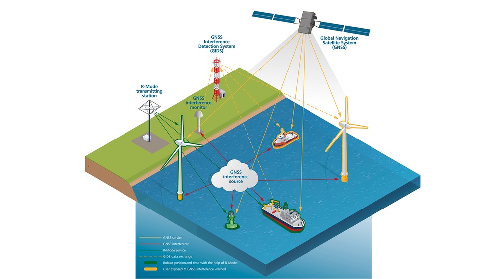
Global Navigation Satellite Systems (GNSS) are today the primary source of information for electronic navigation support for ships. Increasing GNSS interference in the Baltic Sea region is a problem for maritime administrations, which are responsible for providing adequate navigational aids in their waters. The ORMOBASS project addresses this challenge with two technological approaches.
Firstly, the terrestrial navigation system R-Mode, which has so far been operated as a test bed in the southern Baltic Sea, will be expanded as part of the project to include the first core functionalities of the operational system. To this end, new R-Mode transmitters will be set up in the Baltic Sea region, the transmission of R-Mode signals will be expanded, methods of GNSS-independent time synchronisation will be tested and implemented, a central R-Mode monitoring system will be set up, a combined GNSS and R-Mode receiver will be developed and a series of validation measurements will be carried out.
Secondly, GNSS disturbances are to be better detected in order to better inform maritime stakeholders about navigation risks in the future. To this end, a system consisting of land-based GNSS receivers, ship-based sensors and centralised data processing is being set up in a pilot development in Finland. The system aggregates the reports on detected GNSS disturbances, classifies them, creates disturbance situation information and warns maritime users about regional risks.
Partner
German Federal Waterways and Shipping Administration, Germany
Swedish Maritime Administration, Sweden
Federal Maritime & Hydrographic Agency of Germany, Germany