
Hydrology
The Young Drift geography in the northeast is one of Germany’s relatively young geological landscapes. It is characterized by typical glacial meltwater valleys (for example Oder, Havel and Spree); lake-rich plains (such as the Mecklenburg lake district) and outwash plains formed of glacial sediments; ground moraine plains; and terminal moraine belts. At the same time there is a diffuse, undeveloped water network distinguished by many lakes, inland drainage areas and bifurcations, and marked glacial reliefs in contrast to the Old Drift landscapes (Liedtke, Marcinek, 1995; Kwasniowski, 2001).
The DEMMIN test site is characterized by the Trebel, Tollense, and Peene rivers as well as by lake Kummerow (with a surface area of 32.6 km² the fourth-largest lake in the state of Mecklenburg-Western Pomerania). The Tollense has cut a path into the gently rolling ground moraine landscape and is fed by numerous small streams. The meander valley of the Tollense is a floodplain dominated by meadows and pastureland. The water level is regulated by weirs. In contrast to the Tollense, the Peene is navigable; the West, East and Little Peene (“Kleine Peene”), the Tollense, Augraben and the Trebel feed into it. The river depth averages between 2 and 2.50 m, in some places it is over 3 m. The extremely low gradient (averaging 0.03% between Malchin and the mouth of the Peene) and the resulting very low flow velocity are other distinguishing features (Billwitz et al., 2003).
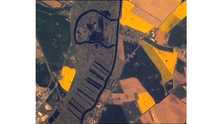
Large areas of the Peene valley are deep moorland (Wachlin, 2000; Hennicke, 2001; ARLV, 2008). The satellite image gives an impression of the Peene region near former peat-cutting sites, with natural landscapes near the prominent river meanders.


The depth to groundwater at the DEMMIN test site varies from 2 m or less to over 10 m. Along the Peene, Tollense, Trebel and Augraben river valleys it varies from 2 m or less to 2 – 5 m, and near the ground moraines between 5 – 10 m; in some cases it is over 10 m. In addition to the rivers, Lakes Kummerow and Malchin are prominent. The water level is 0.2 m above sea level for Lake Kummerow and 0.6 m for Lake Malchin (Statistisches Bundesamt, 2008).
The largest encroachments on the water network are the result of improvements associated with agriculture. The consequences for the landscape have been changes in water resources and the loss of small structural elements such as tarns. The entire study area drains into the Baltic Sea.
According to Haupt (2000) the DEMMIN test site is in Hydrologic Region 7 and Region 8. Region 7, “Northeastern Clay Plains between Peene and Greifswald Bay” is a moraine landscape with average annual precipitation between 550 and 600 mm and terrain ranging from 30 m to 0 m above sea level. The water gauges are located at Hanshagen, Lodmannshagen, Padderow, Gützkow, Schwinge and Grimmen. Region 8, “Back Country of the Lake District between the East Peene and Strassburg” is a ground moraine landscape with average annual precipitation of ca. 600 mm and terrain from 40 to 100 m above sea level. The regional water gauges are in Klempenow, Neubrandenburg, Zirzow, Miltzow, Gielow Süd, Gehmkow, and Usadel.
An important characteristic of the Young Drift landscape is the multitude of natural lakes and cavities, with the water-filled tarns in the agricultural landscape being especially significant (Wegener, 1983). They are the result of inland ice and associated meltwater (Liedtke, Marcinek, 1995; Semmel, 1996).
Literature
ARLV / Amt für Raumordnung und Landesplanung Vorpommern (2008): Entwurf des Umweltberichts zum Regionalen Raumentwicklungsprogramm Vorpommern, Stand: 23. April 2008.- Hrsg: Regionaler Planungsverband Vorpommern, Amt für Raumordnung und Landesplanung Vorpommern.- S. 231. (http://www.rpv-vorpommern.de/uploads/media/RREP_VP_2008_Umweltbericht.pdf)
Billwitz, K., Michaelis, D., Succow, M. (2003): Landschaftsökologische Exkursionen in die Greifswalder Umgebung. - Greifswalder Geographische Arbeiten Band 30.- Hrsg.: Billwitz, K., Michaelis, D., Succow, M..- S. 98.
Buhl, M., Borg, E., Renner, U., Schwarz, J., Löblich, M. (2009): Benefits for Environmental Applications Using TUBSATs Real-Time Video Payload.- In: 7th IAA Symposium on Small Satellites for Earth Observation, Berlin, Germany.- May 04 - 08, 2009. – Poster Session 2 - IAA-B7-1506P.Hennicke, F. (2001): Das Naturschutzgroßprojekt „Peenetal-Landschaft‘‘: In Succow, M., Joosten, H. (Hrsg.) (2001) Landschaftsökologische Moorkunde, 2.Aufl., 622 S. Schweitzerbart’sche Verlagsbuchhandlung, Stuttgart, S. 487-492.
Haupt, R. (2000): Regionalisierung von Hochwasserkennwerten in Mecklenburg-Vorpommern.- (Hrsg.: Miegel, K.), Veröffentlichungen des Institutes für Kulturtechnik und Siedlungswasserwirtschaft der Universität Rostock.- 1- 213.
Kwasniowski, J. (2001): Die Böden im Naturschutzgebiet Eldena (Vorpommern).- Greifswalder Geographische Arbeiten 23.- S. 155-185.
Liedtke H., Marcinek, J. (1995): Physische Geographie Deutschlands.- Justus Perthes Verlag Gotha (2. Aufl.).- S. 374.
Statistisches Landesamt Mecklenburg-Vorpommern (2007): Statistischer Bericht C4935 2007 01, Tabelle 12. Landwirtschaftliche Betriebe 2003 und 2007 nach Hauptnutzungs- und Kulturarten.- S. 20 -21.
Semmel, A. (1996): Geomorphologie der Bundesrepublik Deutschland: Grundzüge, Forschungsstand, aktuelle Fragen, erörtert an ausgewählten Landschaften (5. Aufl.).- Stuttgart (Erdkundliches Wissen, Heft 30).- S 199.
Wachlin, V. (2000): Das Anklamer Stadtbruch ein Naturschutzgebiet im Wandel der Zeiten.- NABU-Nachrichten MV, Sonderausgabe Artenschutz in Mecklenburg.- S. 33-35.
Wegener, U. (1983): Gestaltung wassergefüllter Sölle in der Agrarlandschaft.- In: Archiv f. Naturschutz u. Landschaftsforschung (3).- S. 151 -163.