KLIPS
In the context of climate change, heat islands pose an increasing health risk also in Central Europe and cause considerable damage and costs to infrastructure, e.g. due to burst asphalt surfaces and deformed rails. A system co-developed by EOC supports decision-makers in transportation, urban, and environmental planning in the pilot cities of Dresden and Langenfeld (NRW) with the information they need to plan and evaluate countermeasures.
The research project KLIPS (AI-based information platform for the localization and simulation of heat islands for innovative urban and transport planning) provides an information platform as well as a sensor network developed as part of the project to measure heat islands in cities in detail and allows the simulation of the effects of possible countermeasures using AI algorithms.

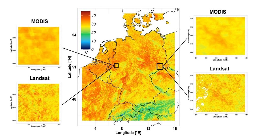
Satellite data from the MODIS and Landsat missions enable measurements of land surface temperatures with high spatial and temporal resolution. Data from the Landsat mission is particularly suitable for intra-urban analyses due to its high spatial resolution. At EOC, both data sets were processed throughout Germany and made available to the project partners in KLIPS (Abbildung 1). In addition, high-resolution land cover information was derived and made available at national level. Together with official geodata from the pilot cities and measurement data from the sensor network, earth observation data products from EOC form the data basis for several neural networks for comprehensive modeling, simulation and forecasting of spatio-temporal temperature patterns and heat islands. This means that users can not only assess the current situation in great detail, but also use a 48-hour temperature forecast of to develop heat action plans or emergency measures. In addition, structural changes can be simulated with the KLIPS system in order to quantitatively compare and evaluate measures in terms of their temperature effect already in the planning phase.

KLIPS started in fall 2020 and was successfully completed in March 2024. Software AG is leading the research project as consortium leader. The research partners are ERGO Umweltinstitut GmbH, the German Aerospace Center, the Fraunhofer Heinrich Hertz Institute, the Institute for Information Systems at Hof University of Applied Sciences, the Leibniz Institute of Ecological Urban and Regional Development, the city of Dresden, Pikobytes GmbH, terrestris GmbH & Co. KG, meggsimum (Büro für Geoinformatik Christian Mayer) and the city of Langenfeld as an associated partner. The project was funded by the Federal Ministry of Digital and Transport as part of the mFUND funding guideline. As part of the funding program, the BMDV has been supporting research and development projects relating to data-based digital innovations for Mobility 4.0 since 2016. The project funding is supplemented by active professional networking between stakeholders from politics, business, administration and research and the provision of open data in the Mobilithek (https://mobilithek.info).


