Formal Opening of Maritime Safety and Security Lab in Neustrelitz
March 28, 2014
Formal Opening of Maritime Safety and Security Lab in Neustrelitz
Dedication of the Maritime Safety and Security Lab in Neustrelitz
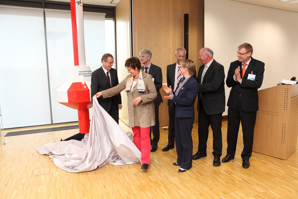
Prof. Johann-Dietrich Wörner, Chairman of the DLR Executive Board, and Brigitte Zypries, Parliamentary State Secretary at the Federal Ministry for Economic Affairs and Energy, unveiled a seamark indicating a safe shipping channel, the symbol of the Neustrelitz Maritime Safety and Security Lab, In the presence of Egbert Schwarz and Thoralf Noack (chairmen of the Maritime Safety and Security Lab); Ina-Maria Ulbrich, State Secretary at the Mecklenburg-Western Pomerania Ministry of Energy, Infrastructure and Development; Eckhardt Rehberg, Chairman of the Mecklenburg-Vorpommern Regional Parliamentary Group; and Prof. Stefan Dech, Director of DLR’s German Remote Sensing Data Center.
Brigitte Zypries, Parliamentary State Secretary at the Federal Ministry for Economic Affairs and Energy, and Prof. Johann-Dietrich Wörner, Chairman of the DLR Executive Board, officially opened the Maritime Safety and Security Lab at the DLR facilities in Neustrelitz on 27 March 2014. The German Remote Sensing Data Center (DFD) collaborates here with the DLR Institute of Communication and Navigation (IKN) on safe shipping and protecting oceans and coastal waters. DFD aims to generate customized information products from satellite data in near-real-time. The necessary algorithms are developed by scientists of the Remote Sensing Technology Institute (IMF) working at the Maritime Safety and Security Lab in Bremen.
In addition to the Bremen facility, other research departments in Oberpfaffenhofen and Braunschweig are part of the Research Cluster Maritime Safety and Security. At those locations seven DLR institutes carry out research on maritime themes following an interdisciplinary approach. "In this association the work carried out in the different research departments, each with its own expertise, is combined to achieve a common goal, to contribute to increasing maritime safety and security through research", explains Prof. Wörner. "The scientists in Neustrelitz are working on dependable communication and navigation systems as well as systems which provide in near-real-time information products for large areas based on satellite data from various sources", he adds.
New challenges for shipping safety and safeguarding the oceans
Explaining the Maritime Information System
Egbert Schwarz shows Brigitte Zypries and Eckhardt Rehberg the integrated maritime information system, which incorporates various types of earth observation and navigation data.
Safety and security at sea are influenced by a number of factors and requires meeting the challenges posed by current global developments. Ship traffic continues to increase worldwide, and ever larger ships are being put into service. Melting ice in Arctic regions opens up the attractive possibility of shorter shipping routes. This, however, implies new dangers because of the scarcity of technical infrastructure along these routes. High waves and an increase in the number of extreme weather events mean additional safety risks, so their early detection is crucial. And finally, it is becoming progressively more important to help prevent illegal fishing, environmental pollution caused by oil dumping, and piracy. In order to protect the oceans, data that provide reliable information about wave heights, sea ice cover, environmental pollution and ship locations are thus of paramount importance.
"This is where earth observation can demonstrate its strength. It provides data about our environment for large areas, continuously, and cost effectively. And thanks to radar, also at night or when visibility is low. We turn the data into customized information products. Our sister institute IMF provides the necessary algorithms while DFD contributes its expertise in receiving and processing enormous amounts of data. This is another example of the proven collaboration of our two institutes, which together comprise the Earth Observation Center (EOC)", explains DFD Director, Prof. Stefan Dech.
Real-time interpretation of satellite data
Explaining data reception and processing
At the real-time center of the German Remote Sensing Data Center, Brigitte Zypries sees a demonstration of satellite data reception and processing in Neustrelitz.
Satellite data provide important information for safety and security at sea: from the location of ships and oil slicks to the identification of problematic ice or wind fields and wave heights. At DFD‘s satellite ground station in Neustrelitz the received data must for that reason be processed as rapidly as possible — in near real time — to yield information products. In light of the huge amount of data involved, this is a considerable challenge. "At the moment it can be done in about 30 minutes", explains Egbert Schwarz, head of the Maritime Safety and Security Lab in Neustrelitz. "In the future we would like to reduce by half the time from data reception to product availability", he adds, "not only to further increase the reliability of the information, but also to make many more information products available within a short time." New algorithms developed by scientists of the Remote Sensing Technology Institute at the Bremen research department are being employed to analyze the satellite data.
Procedures for safe maritime traffic control
Acquiring reliable positioning and navigation data and the overview of the traffic situation that can be derived from them is the essential foundation for guiding a ship safely from port to port. Toward this end, DLR is researching and developing an integrated system for the highly precise and reliable determination of positioning, navigation and timing data (PNT System). The goal is to make it possible for ship captains or navigators on board a ship as well as the , operator of a traffic control center on land to generate a comprehensive and reliable overview of ship traffic using precise positioning and navigation data. This should lead to early recognition and avoidance of collision or grounding risks. In addition to using the data available through the new PNT system, efforts are also under way to fuse these data with data from already operating sensors, including radar and the Automatic Identification System (AIS) for ships, in pursuit of the promising idea of a future cooperative multi-ship effort to ascertain traffic situations.
Research Cluster Maritime Safety and Security
The Research Cluster Maritime Safety and Security consists of four research departments (named Maritime Safety and Security Labs), located at DLR in Braunschweig, Bremen, Neustrelitz and Oberpfaffenhofen. Seven DLR institutes participate in the research cluster. The work of the four departments is financed by the Federal Ministry for Economic Affairs and Energy (BMWi) and the states of Bavaria, Bremen, Lower Saxony and Mecklenburg-Western Pomerania. At the Maritime Safety and Security Lab in Neustrelitz, which is a multi-institute collaboration, the German Remote Sensing Data Center (DFD) and the Institute of Communication and Navigation (IKN) combine their expertise in the areas of maritime traffic technology and satellite-supported near-real-time systems.


