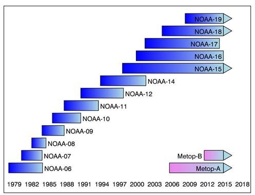
The TIMELINE products are based on AVHRR (Advanced Very High Resolution Radiometer) data. The sensor is set on the meteorological satellites of the NOAA-POES series (Polar-Orbiting Operational Environmental Satellites) and is additionally operated on the MetOp (Meteorological Operational Satellite) satellites by EUMETSAT (European Organisation for the Exploration of Meteorological Satellites). Depending on their start time, the POES satellites are chronologically numbered (NOAA-9 to NOAA-19). NOAA-19 is the last satellite in this series. The MetOp satellites are identified according to their last letter (MetOp-A to MetOp-C).
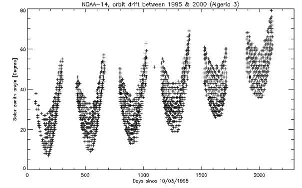
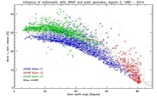
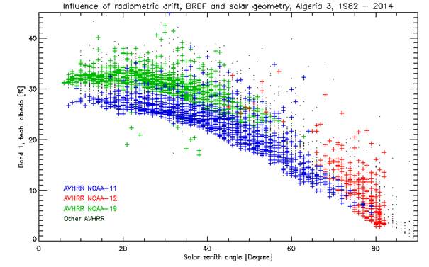
The NOAA-POES as well as the MetOp satellites fly on a sun-synchronous orbit with a nominal operating altitude of 833/820 km (POES/MetOp). The even numbered POES satellites pass the equator at ca. 07:30 am (local time), while the uneven numbers fly over at about 02:30 am and 02:30 pm (local time). The MetOp satellites cross the equator at 09:30 am (local time). Some of the NOAA satellites are subject to a considerable orbit drift – therefore, the time of the overflights changes with the aging of the satellite. Consequently, the solar zenith angles at acquisition differ, which has a strong impact on the measured reflectances.
There are three different types of AVHRR sensors with varying number of bands and spectral ranges. All sensors have two channels in the visible range (channel 1 and 2), one channel in the mid infrared (channel 3B) and one channel in the thermal infrared (channel 4). AVHRR/2 also has a second range in the thermal infrared (channel 5), and NOAA/3 has an additional channel in the mid infrared (channel 3A).
The number of pixels per scan (2048), the scan/sampling time (360 scans per minute), as well as the spatial resolution of 1km at the sub-satellite point (nadir) apply to all sensors.
Channel
AVHRR/1 NOAA-6,8,10
AVHRR/2 NOAA-7,9,11,12,14
AVHRR/3 NOAA-15,16,17,18,19 and Metop-A,B
1
0.58-0.68
0.58-0.68
0.58-0,68
2
0.725-1.1
0.725-1.1
0.725-1.0
3A
-
-
1.58-1.64
3B
3.55-3.93
3.55-3.93
3.55-3.93
4
10.5-11.5
10.3-11.3
10.3-11.3
5
Ch4 rep.
11.5-12.5
11.5-12.5
Channels of the different AVHRR sensors
Operation times of the NOAA-POES and MetOp satellites
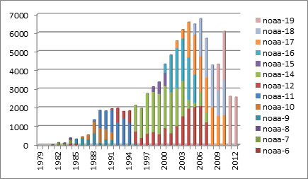
The historic AVHRR data received at DLR-DFD, which is processed within the TIMELINE project (starting in 1981), is in the HRPT (High Resolution Picture Transmission) format. This data was continuously acquired and directly transmitted in real-time from the NOAA satellites to earth. The HRPT data provides the highest possible spatial resolution of the system (1.1km at nadir) and is comparable with the limited available LAC data (Local Area Coverage), whereas the globally available GAC datasets (Global Area Coverage) represent only a subsampling. GAC data contains only every third recorded scanline. Additionally, four of those records are being averaged and every fifth record along the scanline is skipped leading to a resolution of about 4km at nadir. The HRPT/LAC datasets provide a clearly enhanced spatial resolution and thereby enable a valuable historical view of the last century. The continuation of the AVHRR time series by means of MetOp will facilitate the compilation of homogeneous time series in the future.
Number of HRPT scenes in the DIMS archive at DLR-DFD
Since the early 1980s, the DFD has received and processed a considerable amount of AVHRR data. The data is archived in an information technology infrastructure of the DFD (referred to as DIMS) for the management of multi-mission remote sensing products.


