
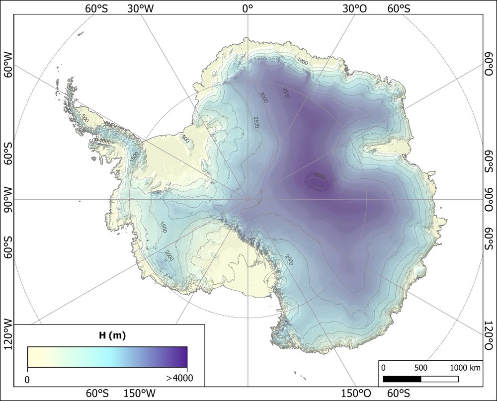
TanDEM-X PolarDEM

The TanDEM-X PolarDEM is a framework for the provision of derivatives of the global Digital Elevation Model (DEM) of the TanDEM-X (TerraSAR-X add-on for Digital Elevation Measurements) mission. The global TanDEM-X DEM is a consistent data set with unprecedented accuracy. It was compiled from interferometric SAR data sets acquired between 2010 and 2014. The resulting global TanDEM-X DEM still faces some limitations that shall be tuned in the turn of this project, specifically for Polar Regions. The derivatives produced in TanDEM-X PolarDEM include edited DEM products, single year coverages and penetration bias corrected DEMs of Polar Regions.
The editing comprises
- gap filling with additional acquisitions,
- smoothing of noisy areas,
- interpolation of voids and,
- replacement of frozen and open sea areas with geoidal heights.
TanDEM-X PolarDEM 90m Products

The goal of the TanDEM-X PolarDEM 90m products is to produce an edited and gap-free version of the TanDEM-X global DEM in Polar Stereographic projection, a metric coordinate system with homogeneous pixel spacing of 90 meters.
The production steps comprised the following steps
- Gaps in the global TanDEM-X DEM are filled using additional TanDEM-X acquisitions where possible.
- The editing process comprises a smoothing of noisy areas, the interpolation of voids and a replacement of frozen and open sea areas with geoidal heights. A semi-automatic approach for coastline delineation was developed and applied to identify the water areas and assign homogeneous height values.
- The editing and gap filling was applied to the TanDEM-X DEM products in their original spacing in geographic coordinates. The TanDEM-X PolarDEM is finally transformed into a cartographic system with a homogeneous metric spacing in northing and easting. At the same time the resolution is reduced to 90 meters.
Time Tagged TanDEM-X PolarDEM 90m
The global DEM of the TanDEM-X mission is a compilation of several acquisition campaigns performed at different years and with different imaging conditions. Usually, the consideration of such multiple acquisitions increases the accuracy of the resulting DEM. An average height resulting from different acquisitions describes well the shape of a glacier or an ice shield but does not reflect the real situation of any of the single acquisition dates. The use of such a DEM e.g. for ice mass balances is limited.
The purpose of the Time Tagged TanDEM-X PolarDEM 90m is to provide the state for a single winter season to broaden the applicability of the elevation models. The calibration and mosaicking is performed in the original product spacing in geographic coordinates. The Time Tagged TanDEM-X PolarDEM is finally transformed into a cartographic system with a homogeneous metric spacing of 90 meters in northing and easting. An editing process is not applied.
In addition, SAR signals are usually not reflected directly on the surface of a glacier. They penetrate into the snow and ice surface which leads to a bias in the measured height. This height bias is dependent on the radar frequency, the imaging conditions like incidence angle and interferometric baseline length, and the physical and dielectric characteristics of the snow and ice layer. This limitation should be considered in a revised version of the Time Tagged TanDEM-X PolarDEM.
For further information, please consult the PolarDEM Product Description (see Links).
Status and availability:
- TanDEM-X PolarDEM 90m of Antarctica (available)
TanDEM-X PolarDEM 32m of the Arctic (will be released soon)
- Greenland (in processing)
- Iceland (to be released)
Time Tagged TanDEM-X PolarDEM 90m Greenland
- Winter 2010 / 2011 (in processing)
- Winter 2016 / 2017 (in processing)
Duration: 2017 – ongoing