
Global WaterPack (GWP)
Water is essential to all forms of life. The rhythm of water determines economy and forms ecosystems. Natural lakes, wetlands, floodplains and artificial water reservoirs often undergo pronounced seasonal dynamics in their areal extent. The extent of open water surface is essentially depending on climate, relief, land cover and human intervention. These factors can cause regular fluctuations or clear trends over a long period of time or, in extreme weather conditions, cause sudden, large-scale changes. A comprehensive knowledge of global spatial-temporal patterns of water surfaces is of great importance to understand different natural and man-made processes and their effects. In this context, a detailed recording, observation and quantification of water surfaces for the development of effective sustainability strategies in connection with climate change and water use is of high importance for our understanding of natural processes and can also act as basis for political and planning decisions.
Observation of water dynamics with satellite remote sensing
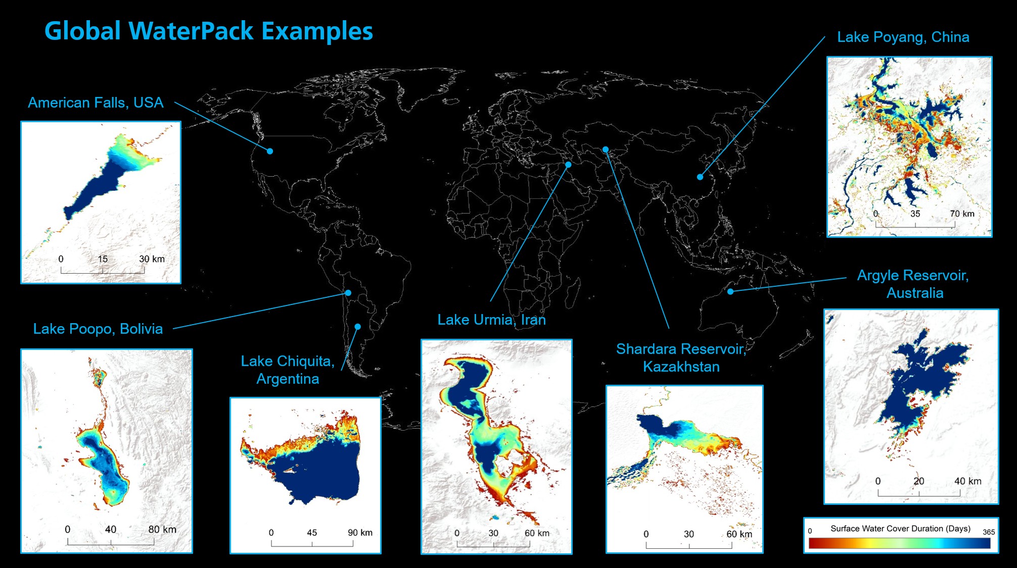
The aim of the Global WaterPack (GWP) project is the worldwide mapping of surface water for every single day. So far, over 5 million individual images from the MODIS (Moderate Resolution Imaging Spectroradiometer) sensor of the two satellites Terra and Aqua between the years 2003 to 2020 have been processed and analyzed (approx. 180 terabytes of raw data). As a result of this complex, fully automatic evaluation, the Earth's surface is divided into two types of land cover every day: open surface water and no open surface water. By aggregating the daily results, spatial-temporal patterns of lakes and reservoirs become visible, and their properties can be examined and described. The GWP annual frequency layer shows the number of days within a year on which open surface water occurs in a certain place on Earth. Depending on the region, drastic differences are visible: While lakes of the mid latitudes hardly change over the year, the extent of open surface water of lakes and wetlands in the subtropics or in permafrost areas fluctuates extremely within a year. Artificial reservoirs also show significant seasonal fluctuations. Lakes in northern latitudes and mountain regions, on the other hand, indicate when and for how long the water freezes. Long-term means, anomalies and - in the future - trends can be obtained from the analysis of the derived time series. This enables to observe and quantify long-term environmental changes.

When considering the entire range of GWP, one can observe the water dynamics as well as lake ice dynamics on a global scale. The filling and emptying of artificial reservoirs, as well as the natural dynamics of flood plains along large rivers, can be clearly determined in terms of time. Thus, this data set provides a comprehensive basis for further quantitative and qualitative evaluations of spatial-temporal water dynamics.
Improved data for various fields of science and modelling of future developments:
The GWP offers great potential for improving climate and hydrological modelling, water-related risk analysis or assessing the human impact on various ecosystems. The data set can also serve as a starting point for long-term worldwide monitoring of historical and future water surface dynamics. Furthermore, this enables an implementation of comparative analyses between different river catchments around the world. Thus, the GWP provides an important input for hydrological analyses, geoscientific modelling and water resource management. Water availability, water demand, extreme events such as droughts, heavy precipitation, snowmelt and floods can be examined with a high temporal resolution.
Downloads
- References GWP (96.4 KB)