Geo-ForPy - Understanding forest cover structures to conserve biodiversity in the Paraguayan Chaco
In the last 40 years, Paraguay has lost most of its natural forest area, becoming one of the countries with the highest rate of deforestation in the world. Rapid expansion of agricultural land, cattle ranching, and illegal logging have transformed the last remnants of forest into isolated patches, threatening their connectivity and the biodiversity within them. In response to these events, the Paraguayan government has implemented numerous environmental programs and regulations to repair the damage done in the past.
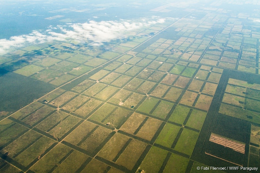
The Paraguayan Chaco covers the western part of the country and occupies 60 % of its territory. The area is characterized by a mosaic of vegetation types, composed of forests and dry woodlands, combined with riparian vegetation, savannas and grasslands. It is also one of the last wilderness areas in the tropics. The Paraguayan Chaco has become an important center of economic development in recent years. Cattle ranching has increased in this area and has become one of the economic backbones of the country. Artificial pastures have continued to displace natural vegetation, leading to increasing fragmentation of the forest. This development has come at the expense of natural resources and has severely impacted wildlife habitat in the region.

Objectives of Geo-ForPy
The overall goal of the "Geo-ForPy" project is to gain an in-depth understanding of forest cover structure to support biodiversity conservation in the Paraguayan Chaco. To achieve this goal, the project contributes with the following activities:
- An improved mapping of forest cover in the Paraguayan Chaco based on high resolution satellite data. This information will be used to identify areas where sustainable forest management practices could be applied.
- The degree of forest fragmentation in the region and the connectivity between forest patches and biological corridors will be examined using landscape metrics. This information will be used to identify priority areas for conservation and to analyze forest dynamics in protected areas, indigenous reserves, and adjacent areas.
- The implementation of forest policies and laws in the Paraguayan Chaco will be analyzed based on historical and current multitemporal Landsat imagery. This will provide essential information to understand the impacts of past and current forestry policies and derive tailored recommendations considering each land tenure category.
- The knowledge exchange based on training courses and workshops will target Paraguayan environmental agencies (governmental and non-governmental), research institutions and interested stakeholders.
Partner
The GeoForPy consortium, led by DLR, consists of the Faculty of Engineering of the National University of Asuncion (FIUNA), the Faculty of Agricultural Sciences (FCA), the National Forestry Institute (INFONA), the Paraguayan Environmental Secretariat (MADES) and the non-profit civil society organization Guyra Paraguay. GeoForPY is a research project funded by the German Federal Ministry of Food and Agriculture (BMEL) as part of the International Research Program for Sustainable Forestry.
Selected Results
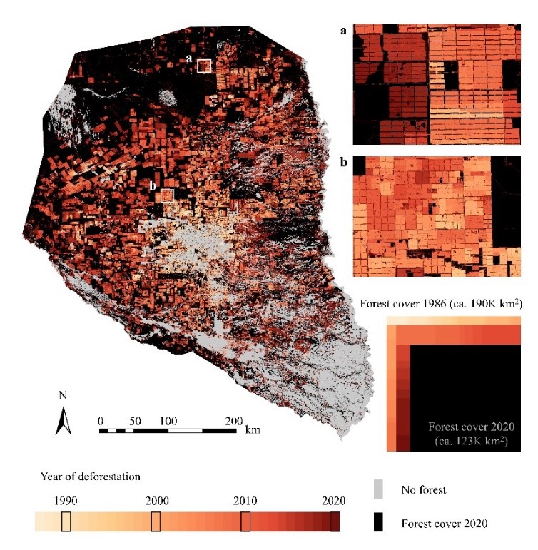
Monitoring Annual Forest Cover in the Paraguayan Chaco from 1987 to 2020
The analysis of the evolution of forest cover in the Paraguayan Chaco was one of the main objectives of Geo-ForPy. Using the entire Landsat archive between 1987 and 2020, an in-depth analysis was performed over the last 34 years. For each year, a random forest (RF) classifier was used to create binary forest maps based on multitemporal spectral metrics. In 1987, almost 78% (188,000 km2) of the Paraguayan Chaco region was covered by forest. Since then, however, continuous deforestation took place, and the derived numbers of annual forest area losses show that deforestation was proceeding at an increasing rate. Between 1987 and 1995, approximately 820 km2 of forest land was lost each year (i.e. an annual deforestation rate of 0.4 %). Until 2007, the rate of deforestation doubled, reaching an annual deforestation rate of 1,550 km2 (0.8 %). Annual forest loss between 2008 and 2020 shows a further doubling of the deforestation rate, with annual losses of 3,200 km2 (1.7 %) recorded during these 13 years. Thus, in 2008, 2013, and 2019, deforestation rates increased abruptly, reaching levels four to five times higher than in previous years. These trends can be explained as a direct consequence of global agricultural commodity prices.

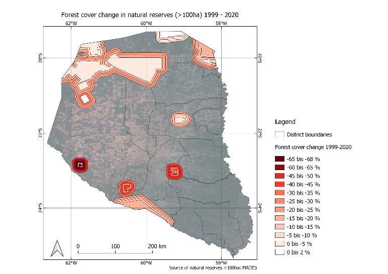
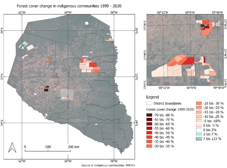
Deforestation in and near by protected areas and indigenous communities
The areal maps show that forest loss within the boundaries of protected areas represents only 1% (550 km2) of the total area deforested in the Paraguayan Chaco between 2000 and 2020. However, there are individual protected forest areas where up to 25% of the forest was cleared between 2000 and 2020. In addition, the loss of forest area in most protected areas is increasing dramatically outside the boundaries of the protected areas, with rates ranging from 8% to 60%. For example, in the Palmar Quemado, Yaguarete Pora, Cerro Chovoreca, and Defensores del Chaco protected areas, little forest is being cleared within their boundaries. However, forest loss increases dramatically in the 5 km buffer zone, where nearly 67% (166 km2), 9% (32 km2), 12% (55 km2), and 17% (605 km2) of the forest has been cleared, respectively.


Forest Fragmentation
Using a set of metrics for landscape analysis, namely core area, forest patch size, total edge, edge density, and proximity, forest fragmentation was assessed in 2000, 2010, and 2020. The above-mentioned forest loss is associated with a significant decrease in core area and a doubling in the number of forest patches (12,010 in 2000 to 23,228 in 2020). The average size of a forest plot decreased from 14 km2 in 2000 to 5 km2 in 2020, and the total core area decreased by more than 60%. While 64% of the total forest area was in the core zone in 2000, this percentage decreased to 37% in 2020. In addition, an increasing complexity of forest land form was observed. The total boundary of all forest land increased from 310,300 km in 2000 to 433,200 km in 2020, while the length of the boundary of an average forest patch decreased at the same time. In addition, a neighborhood assessment was conducted to identify forest patches in terms of their embeddedness in the fragmented forest area. Proximity between patches can be used to identify potential biological corridors that allow for species movement and dispersal. During the study period, this index also decreased. It is notable that there is a clear trend in all of the metrics. Today, only the northern part of the Paraguayan Chaco can be considered a contiguous forest. Nevertheless, even in the north, both proximity and the core area index have declined sharply. Patches with a large proportion of core area have disappeared over the 20 years of the study, leaving only one region with a large core area index in the north (72-80%), the Defensores del Chaco Nature Reserve. The surrounding areas have much lower percentages of core area, making the protected area an isolated island.
Vegetation Structure


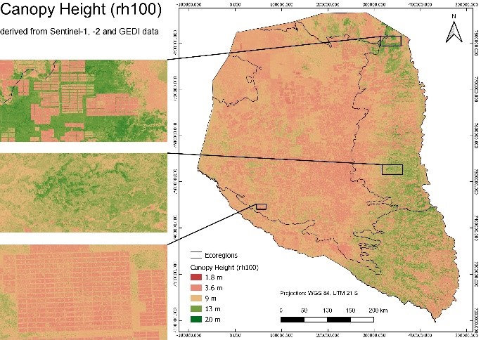
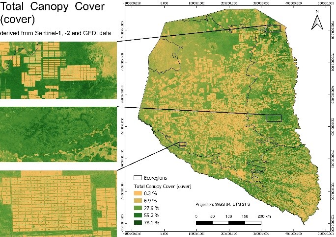
Information on vegetation structure is key information in determining wildlife habitat quality and terrestrial carbon storage. Thus, large-scale maps of tree canopy height and vegetation density are particularly important in an era of global climate change. Novel spaceborne LiDAR samples from the Global Ecosystem Dynamics Investigation (GEDI) sensor provide attributes of vegetation structure as footprint data for all temperate and tropical forests. Modeling of GEDI samples based on high-resolution mapping missions such as Sentinel-1 and -2 provides continuous vegetation structure information. We implemented a random forest regression model to extrapolate GEDI samples based on temporal-spectral features from Sentinel-1 and -2 to 10-m resolution data that include canopy height, total canopy cover, plant-area index, and foliage-height-diversity index.
Publications
Peer-reviewd papers
- Kriese, J., Hoeser, T., Asam, S., Kacic, P., Da Ponte, E., Gessner, U., Deep learning on synthetic data enables the identification of deficient windbreaks in the Paraguayan Chaco. Remote Sensing 2022, 14, 4327. https://doi.org/10.3390/rs14174327
- Da Ponte, E., García-Calabrese, M., Kriese, J., Cabral, N., Perez de Molas, L., Alvarenga, M., Caceres, A., Gali, A., García, V., Morinigo, L. et al. Understanding 34 Years of Forest Cover Dynamics across the Paraguayan Chaco: Characterizing Annual Changes and Forest Fragmentation Levels between 1987 and 2020. Forests 2022, 13, 25. https://doi.org/10.3390/f13010025
- Kacic, P., Hirner, A., Da Ponte, E., Fusing Sentinel-1 and -2 to Model GEDI-Derived Vegetation Structure Characteristics in GEE for the Paraguayan Chaco. Remote Sensing 2021, 13, 5105. https://doi.org/10.3390/rs13245105
Conference Presentations
- Kacic, P., Hirner, A., Da Ponte, E. (2022), Vegetation structure modelling and explorative statistics based on Sentinel-1, -2, and GEDI in the Paraguayan Chaco. ForestSAT 2022, 29 August - 3 September 2022, Berlin.
- Kacic, P., Da Ponte, E., Hirner, A. (2022), Fusing Sentinel-1 and -2 to model GEDI-derived forest structure of the Paraguayan Chaco, presentation of a workflow in Google Earth Engine (GEE). XV World Forestry Congress 2022, 2-6 May 2022, Online.
- Kacic, P., Da Ponte, E. (2021), Forest-Structure Analysis in the Paraguayan Chaco, combining Sentinel and GEDI data. EARSeL Symposium 2021, 7-10 June 2021, Online.
- Garcia Calabrese, M., Salinas Romero, S., Cassacia Ibarrola, C., Morinigo, L., Alvarenga, M., Da Ponte, E. (2021), Understanding the relationship between environmental policies and deforestation activities in the Paraguayan Chaco. EGU General Assembly 2021, 19-30 April 2021, Online.
Master Theses
- Kacic P. (2021), Forest Structure Analysis in the Paraguayan Chaco Based on Sentinel-1, Sentinel-2 and GEDI Data. Albert-Ludwigs-University Freiburg.
- Zamora O. C. E. (2021), Deforestation dynamics in the Dry Chaco ecoregion: a three decades of change detection and fragmentation study analysis. Julius-Maximilians-University Würzburg.