SCIAMACHY
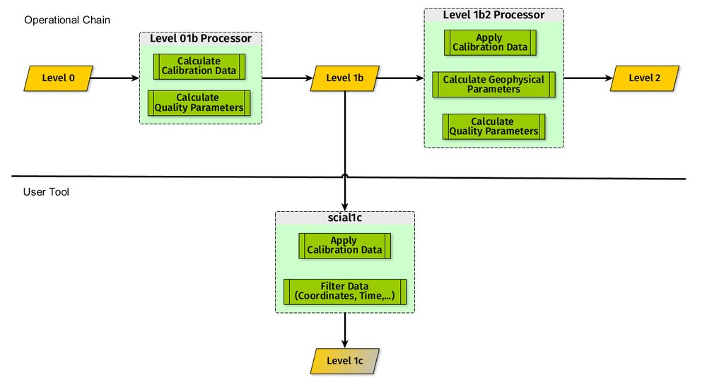
Die Operational data processing is designed to provide users with Level 1 and Level 2 data continuously. The levels are defined as follows:
- Level 1b: data containing all the auxiliary data need for calibration as well as the geographical coordinates of the recorded ground pixels,
- Level 1c: calibrated data, in other words, solar radiance intensity and the intensity of the part of Earth’s atmosphere under observation as a function of wavelength,
- Level 2: geophysical values such as trace gas content of the atmosphere or extent of cloud cover.
There are two processing stages – Level 0-1b with an optional Level 1c, and Level 1b-2. The Level 0-1b processing (versions 8 and 9) is performed since 2010 with the processor GCAPS (Generic Calibration and Processing System) being developed at IMF-ATP.
In general, the recording of the calibration data required for Level 0-1b processing does not take place at the same time as the atmosphere measurements themselves. It is therefore necessary to process both types of data separately. GPAS contains a database for the storage and retrieval of calibration parameters computed from the input data. For any given atmosphere data set, appropriate calibration data—usually that which is closest in time—can be defined and incorporated in a Level 1b data set along with geolocation information. The calibration algorithms were developed together with SRON (Netherlands Institute of Space Research), whereas the operational processor initially was provided by industry (Jena Optronik) according to IMF specifications and since 2010 it is directly providet by DLR.
Many users require Level 1c data for their own purposes. This requirement can be met with the software package SciaL1c, which was developed for ESA by the IMF Atmospheric Processors department. It permits the selection of all, individual, or any combination of calibration steps for Level 1b data in order to generate a customized Level 1c product.
Parameter | Wavelength Range (nm) | Algorithm (Institute) |
|---|
Absorbing Aerosol Index | 340-380 | Algorithm of KNMI |
Ozone (O3) | 325-335 | GDP4/SDOAS (BIRA) |
Nitrogen dioxide (NO2) | 426.5-451.5 | GDP4/SDOAS (BIRA) |
tropospheric NO2 | 426.5-451.5 &
420 - 470 | Limb/Nadir matching (IUP Bremen) |
Bromine oxide (BrO) | 336-351 | GDP4/SDOAS (BIRA) |
tropospheric BrO | 336-351 | Observations fit to (CTM) model (BIRA) |
Sulfur dioxide (SO2) | 315-327 | GDP4/SDOAS (BIRA/IUP Bremen) |
Chlorine dioxide (OClO) | 365-389 | GDP4/SDOAS (BIRA/IUP Bremen) |
Formaldehyde (HCHO) | 328,5-346 | GDP4/SDOAS (BIRA) |
Glyoxal (CHOCHO) | 435-457 | GDP4/SDOAS (BIRA/IUP Bremen) |
Water vapor (H2O) | 688-700 | AMC-DOAS (IUP Bremen) |
Carbon monoxide(CO) | 2324.4 -2335 | BIRRA (MF-ATP) |
Methan (CH4) | 1557.18 - 1594.13 & 1628.93 - 1670.56 nm | BIRRA (IMF-ATP) |
Extent of cloud cover | 300 - 800 | OCRA (IMF-ATP & SPICI (SRON)) |
Cloud top and optical density | 758 - 772 | SACURA (IUP Bremen) |
Limb | | |
Ozone (O3) Profile | 283-310 & 520 -590 | DRACULA (IMF-ATP) |
Nitrogen dioxide (NO2) Profile | 420 - 470 | DRACULA (IMF-ATP) |
Bromine oxide (BrO) Profile | 337 - 357 | DRACULA (IMF-ATP) |
Cloud detection (high resolution) | Varies with cloud type | SCODA (IUP Bremen) |
Operational Level 1b-2 processing begins with internal processing to Level 1c, in other words, to calibrated spectra. After deriving parameters for use when later calculating trace gas concentrations (for example, the extent of cloud cover), a classification is made according to the observation geometry—limb or nadir. Only then does the actual retrieval (determination of trace gas concentrations) take place, with the results being collected in a Level 2 data set for each orbit. The new Version 7 of the data processor, which became operational in March 2018, covers the atmosphere parameters listed in the table. The table also includes an overview of the algorithms employed.
There is more information about calibrating absorption spectrometers on the calibration page of the "Team Sensor-specific Methods" of the "Atmospheric Processors Department".
Links


