With Earth Observation Against Heat Islands
Heat islands represent an increasing health risk also in Central Europe in light of climate change, and cause considerable damage and expense to infrastructure, for example through ruptured asphalt surfaces and deformed tracks. A system co-developed by EOC is now providing decision-makers in the pilot cities of Dresden and Langenfeld (NRW) with an information basis to plan and evaluate countermeasures in traffic, urban and environmental planning.
In the KLIPS research project (an AI-based information platform to localize and simulate heat islands for innovative urban and traffic planning), an information platform is being used together with a sensor network developed as part of the project to provide detailed measurements of heat islands in cities and to simulate the effects of possible countermeasures with the help of AI algorithms.

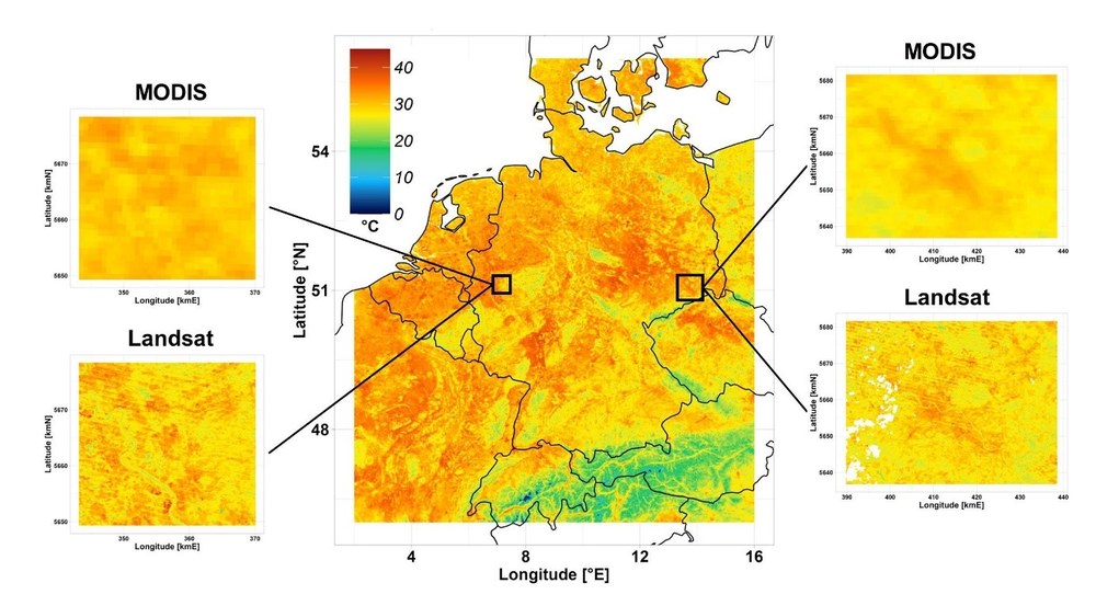
Satellite data from the MODIS and Landsat missions make possible surface measurements with high temporal and spatial resolution. Data from the Landsat mission are especially suitable for intra-urban analysis because of their spatial resolution. At EOC both data sets were processed for all of Germany and made available to project partners as part of KLIPS (Figure above). In addition, high-resolution land cover information for the national level was computed and made available. Together with official geodata for the pilot cities and measurement data from the sensor network, the EOC satellite data products form the data basis for several neuronal nets to achieve full-coverage modeling, simulation and prediction of spatial-temporal temperature patterns and heat islands. End users can thus not only interpret the momentary situation in high detail, but also consult a 48-hour forecast of heat development, for example to draw up heat reaction plans or emergency measures. The KLIPS system can also be used to simulate civil infrastructure changes in order to quantitatively compare and evaluate their temperature effects already in the planning phase.

KLIPS was launched in autumn 2020 and successfully concluded in March 2024. Software AG was in charge of the research project as consortium head. Research partners were ERGO Umweltinstitut GmbH, The German Aerospace Center DLR, Fraunhofer Heinrich-Hertz Institut HHI, the Institute for Information Systems at Hof University, the Leibniz-Institute of Ecological Urban and Regional Development, the provincial capital Dresden, Pikobytes GmbH, terrestris GmbH & Co. KG, meggsimum (Büro für Geoinformatik Christian Mayer), and the city of Langenfeld as associate partner. The project was financed following the mFUND funding guideline of the Federal Ministry of Transport and Digital Infrastructure (BMDV). As part of the financing program, BMDV has supported research and developments projects related to data-based digital innovations for Mobilität 4.0 since 2016. Project support is complemented by active thematic networking among actors from the political, economic, administrative and research sectors and by providing freely available data via Mobilithek (https://mobilithek.info).
