Ozone layer on the way to recovery – WMO/UNEP report published
February 28, 2023
Ozone layer on the way to recovery – WMO/UNEP report published
The World Meteorological Organization (WMO) and the United Nations Environment Programme (UNEP) published in February the latest status report on the ozone layer of Earth’s atmosphere (Scientific Assessment of Ozone Depletion 2022). EOC scientists played a significant role as authors and reviewers in drawing up the report.
Since the discovery of the ozone hole over the Antarctic in 1985, a status report of some five hundred pages has appeared every four years summarizing the latest insights on the condition and future development of the ozone layer. The analyses give signs of its recovery beyond the polar regions in the upper stratosphere and over the Antarctic in the lower stratosphere in September. A positive trend in the global (60°S-60°N) mean value of total column ozone was noted for the period 1996-2020. Long-term changes can, however, differ greatly from region to region. The trend is currently most prevalent in the southern hemisphere. In other regions it is currently difficult to ascertain because of strong natural variability and such factors as the influence of climate change and changes in the troposphere. In addition, atypical events such as volcanic eruptions, forest fires or abrupt disturbance of the QBO (Quasi-Biennial Oscillation) in the tropics can initiate at short notice processes that influence the ozone layer in the stratosphere. it is anticipated that the ozone values measured before 1980 can be achieved from about 2040, and later in the polar regions. At present these values are about 1-5% lower than the 1964-1980 level.
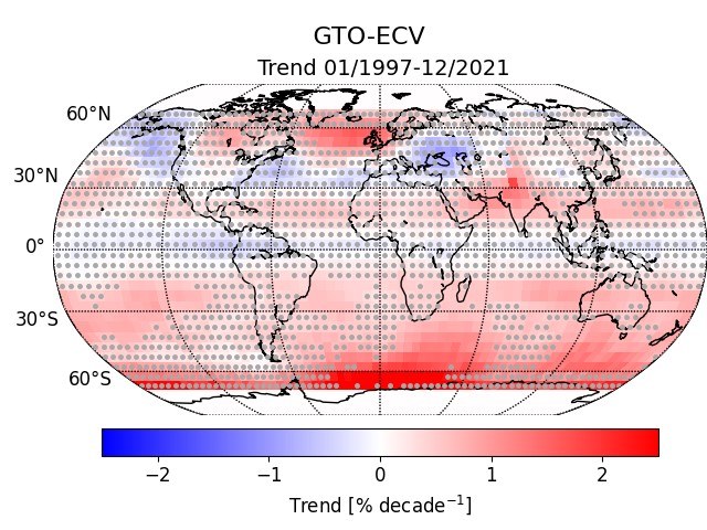
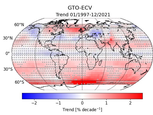
Ozone trends 1997 - 2021
Total column ozone trends derived for the period 1997–2021 in % per decade. Trends are derived from satellite sensor measurements from the GOME, SCIAMACHY, OMI and TROPOMI (GTO-ECV) instruments. Grey dots indicate locations at which trends with a 95% confidence level are insignificant.
A decisive foundation for the status report is provided by satellite-based measurements that provide a global, spatially well-resolved depiction of ozone concentration. At EOC the data records of various passive sensors of the GOME type (Global Ozone Monitoring Experiment) are combined in the framework of the DLR MABAK project and projects of the EU Copernicus Climate Change Service (C3S) to produce a climate data set that meanwhile extends over the past 28 years (1995-2023). This makes it possible to precisely analyse the spatial and temporal variability of ozone concentration. Moreover, continuous expansion of the data record is urgently required in order to minimize uncertainties about the long-term development of the ozone layer. Toward this end, since 2018 the TROPOMI instrument on the EU/ESA Sentinel-5 Precursor (S5P) satellites has also been extending the data record of GOME, SCIAMACHY, OMI and GOME-2.
At DLR data from the TROPOMI instrument are evaluated in the framework of the ESA/EU S5P project and data from the GOME-2 instrument are analysed for the EUMETSAT project AC-SAF. Ozone hole animations are regularly published as part of the DLR INPULS project.
The ozone hole as measured by TROPOMI in 2022
Your consent to the storage of data ('cookies') is required for the playback of this video on Quickchannel.com. You can view and change your current data storage settings at any time under privacy.
Milestone in international environmental legislation
The ozone layer protects people and the environment from the energy-rich ultraviolet range of solar irradiance. Only in the mid-1980s was it discovered that the chlorofluorocarbons (CFCs) used in industry and households during the 1930s break down the ozone layer.
Shortly after discovering the ozone hole, UN member states committed themselves in 1987 in the Montreal Protocol to reduce and in due course completely eliminate the emission of the ozone-destroying chemicals chlorine and bromine. The protocol is considered a milestone of successful international environmental legislation. Since the end of the 1990s a continuous reduction of these long-life, harmful substances has been confirmed. This brought a halt to further thinning of the ozone layer and initiated its regeneration.


