The MODIS sensor onboard the TERRA satellite, was launched on December 18, 1999. On May 4, 2002 the second MODIS sensor followed onboard AQUA. The 'Moderate Resolution Imaging Instrument' MODIS, a 36-channel imaging spectrometer with a pixel size of 250 m, acquires a global data coverage within one to two days. Detailed technical specifications can be found on the NASA MODIS pages.
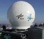
On January 16, 2001 the antenna was installed
on the roof of the DLR German Remote Sensing Data Center building in Oberpfaffenhofen and put into operation for MODIS reception.
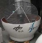
The DLR 3.60 m parabolic X-band receiving antenna is housed in a protective 4.20 m radome. The antenna, manufactured by SeaSpace Corporation, is fully pivotable - 360 degrees azimuth, +/- 90 degrees elevation , +/- 20 degrees tilt.
On January 16, 2001 the antenna was installed on the roof of the DLR German Remote Sensing Data Center building in Oberpfaffenhofen and put into operation for MODIS reception.
Data
The German Remote Sensing Data Center acquires about eight gigabyte of MODIS data per day. Level 1b data specifications correspond to NASA specifications MOD35.