
Fine-grained Road Segmentation by Parsing Ground and Aerial Images (HD-Maps)
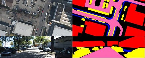
HD-Maps is a dataset used in our research for proposing a method which enriches road maps by including spatially high-resolution features such as the number and width of lanes, sidewalks, and parking lanes. This method considers the already existing maps together with the aerial and ground photographs. The decisive factor in this process is that road maps, aerial photographs and terrestrial images are processed in a single step. The image characteristics and the constraints of the width of the tracks and the structure of the road layout are considered together. This allows a robust estimation, even if only little image information is available, e.g., if the road markings are missing or not visible. The registration of the aerial photographs with the terrestrial images is necessary, since the required accuracy cannot always be maintained even when very precise GPS inertial systems are used. This registration can also be considered as precise localization, which is very important for route planning and autonomous driving.


The dataset used in this research work together with the annotated aerial and ground images are available under "Downloads". If you use the data, please cite this paper.
Mattyus, Gellert und Wang, Shenlong und Fidler, Sanja und Urtasun, Raquel (2016) HD Maps: Fine-grained Road Segmentation by Parsing Ground and Aerial Images. In: Proceedings of Computer Vision and Pattern Recognition 2016, Seiten 1-9. IEEE Xplore. Conference on Computer Vision and Pattern Recognition, 27-30 June 2016, Las Vegas, USA.