Caralis Chaos – impressions from the shores of former Lake Eridania


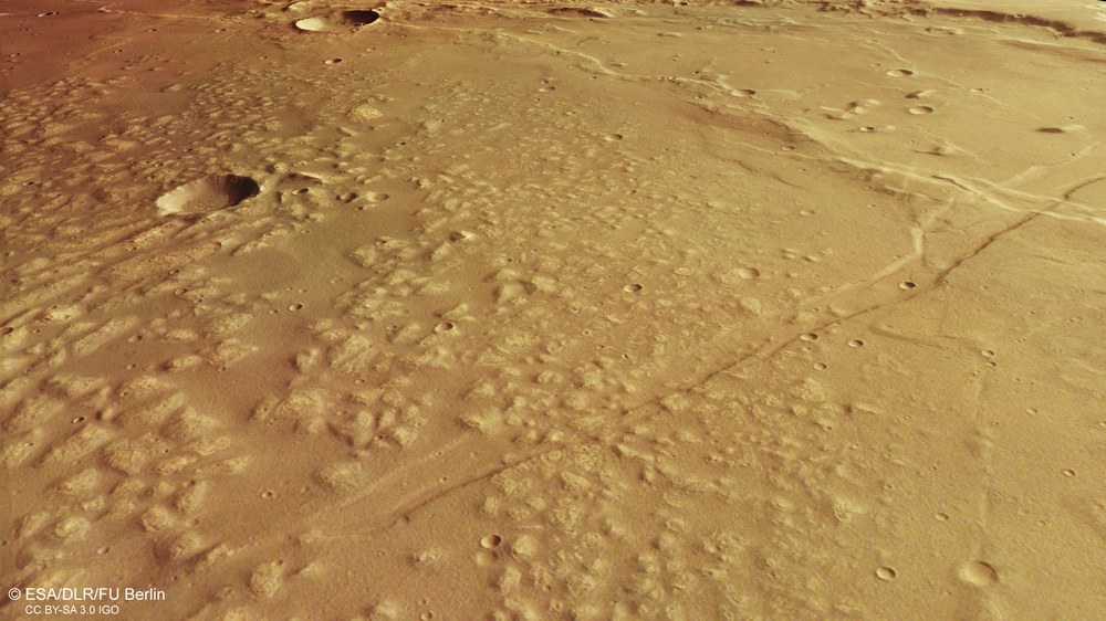
- DLR's High Resolution Stereo Camera (HRSC) shows the chaotically shaped landscape of Caralis Chaos on Mars.
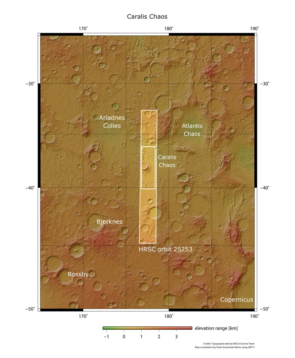
- Researchers assume that Caralis Chaos and the neighbouring region, Atlantis Chaos, are home to the remains of the former Lake Eridania.
- Spectroscopic analyses indicate the presence of very old deposits that were later covered by water and weathered away.
- Focus: Spaceflight, planetary research, Mars Express
Caralis is not only the Latin name of the city of Cagliari in Sardinia, but also the moniker for a 'chaotic' area of Mars where ridges, cracks and plateaus appear to be interwoven in a jumbled pattern. Image data acquired by the High Resolution Stereo Camera (HRSC) from the German Aerospace Center (Deutsches Zentrum für Luft- und Raumfahrt; DLR) on ESA's Mars Express spacecraft provide an impressive illustration of this landscape from the region between Terra Cimmeria and Terra Sirenum.
The area has several enigmatic regions with small hills located in large basins. It was first mapped thanks to images from NASA's two Viking missions, which arrived on Mars in 1976. The Caralis Chaos mounds within differ in various ways from the other chaotic landscapes of Mars – such as the Hydraotes Chaos region at the eastern end of the Valles Marineris and the northward-pointing valleys there, which once channelled large quantities of water into the northern lowlands. For one, the Caralis Chaos mounds have no direct connection to such a drainage channel.
A changing lake landscape
In Mars research, it is believed that Atlantis Chaos and Caralis Chaos are home to the remains of the ancient Lake Eridania. The lake is dated to the middle-to-late Noachian period, when most of the rivers and lakes on Mars were active. It likely extended over approximately 1.1 million square kilometres and may have been the source of the large Ma'adim-Vallis outflow channel further north. It later split into smaller, isolated lakes that eventually evaporated and seeped away, along with much of the rest of the planet's water. The Noachian period began approximately 4.1 billion years ago and lasted around 400 million years. It was the most water-rich period on Mars.
Parts of Caralis Chaos can be seen in the northeast of the scene, and bottom-right in the plan views. As spectroscopic analyses indicate, the hilly and light-coloured material could be a very old deposit that was later covered and eroded by water. When the lakes dried up, the material broke up and was then further eroded by the wind. Later, the tectonic faults of the Sirenum Fossae ('the trenches of the sirens') overlay the landscape and cut through both the mounds on the right and the smooth surface on the left (southern) side of the picture.
Powerful volcanic forces
A very interesting feature in the region is the large number of wrinkle ridges, which are typical characteristics of volcanic plains. Wrinkle ridges are formed when a lava layer is compressed while it is still slightly soft and elastic, deforming under the stress caused by the continuous pressure of newly produced, overlying lava.
The area surrounding the 30-kilometre impact crater in the centre of the image, with its strikingly flat floor, is also remarkable. Distinctive flow structures and small valleys can be seen on the outer southern flanks of the crater, shown towards the left in the image, indicating evidence of water activity in a later period.
On closer inspection, small valleys can be identified in many places outside this crater, through which water once flowed. The smaller crater in the immediate southern vicinity has small gullies on its northern flank, and the material transported down the slope here appears to have eroded or shifted parts of the crater material on the ground. On the upper-right side of the image is a fragmented plateau with a smooth surface, where the remains of several heavily weathered or lava-flooded impact craters can be seen in the form of various circular structures.
Image processing
The images were acquired by the HRSC (High Resolution Stereo Camera) on 1 January 2024 during Mars Express orbit number 25,235. The ground resolution is approximately 15 metres per pixel and the image is centred at about 177 degrees east and 38 degrees south. The colour image was created with data from the HRSC's nadir channel – the field of view oriented perpendicular to the Martian surface – along with the camera's colour channels.
The oblique perspective view was created from the digital terrain model (DTM) in tandem with the camera's nadir and colour channels. The anaglyph image, which conveys a three-dimensional impression of the landscape when viewed with red/blue or red/green glasses, was derived from the nadir channel and a stereo channel. The colour-coded view is based on a DTM of the region, from which the topography of the landscape can be derived. The reference body for the HRSC DTM is an equipotential surface of Mars (areoid).
Map server
To download the released raw images and Digital Terrain Models (DTM) of the region in GIS-compatible formats, follow this link to the map server.
The HRSC experiment on Mars Express
The High Resolution Stereo (HRSC) was developed at the German Aerospace Center (DLR) and built in cooperation with industrial partners (EADS Astrium, Lewicki Microelectronic GmbH and Jena-Optronik GmbH). The science team, led by Principal Investigator (PI) Daniela Tirsch from the DLR Institute of Planetary Research, consists of 52 co-investigators from 34 institutions and 11 nations. The camera is operated by the DLR Institute of Planetary Research in Berlin-Adlershof.
