Aganippe Fossa – a 600-kilometre-long valley with an unclear origin
The Aganippe Fossa valley lies at the north-western flank of the Arsia Mons volcano. The boundary walls of the graben are three to seven kilometres apart. It is not clear how the Aganippe Fossa was formed: the scar could have been created as a result of volcanic activity in the region as a graben of tectonic origin and crustal expansion. However, the appearance and shape of the Aganippe Fossa also suggests that these long depressions were formed as a result of the collapse of the cover of underlying lava tubes. A cavity is created as the lava flow inside continues to flow and drain through this insulating rock cover. When the roof of this tunnel collapses, the semi-tubular flow channel remains.
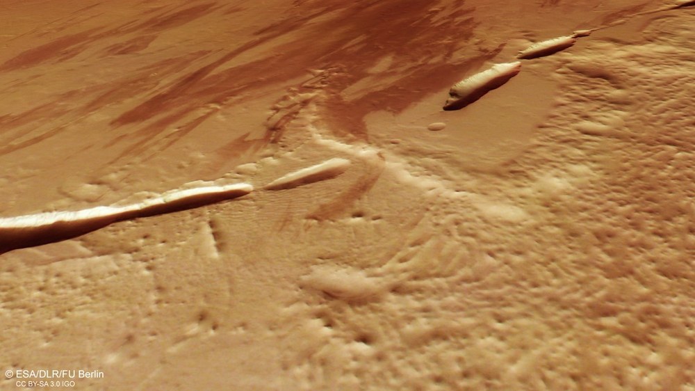
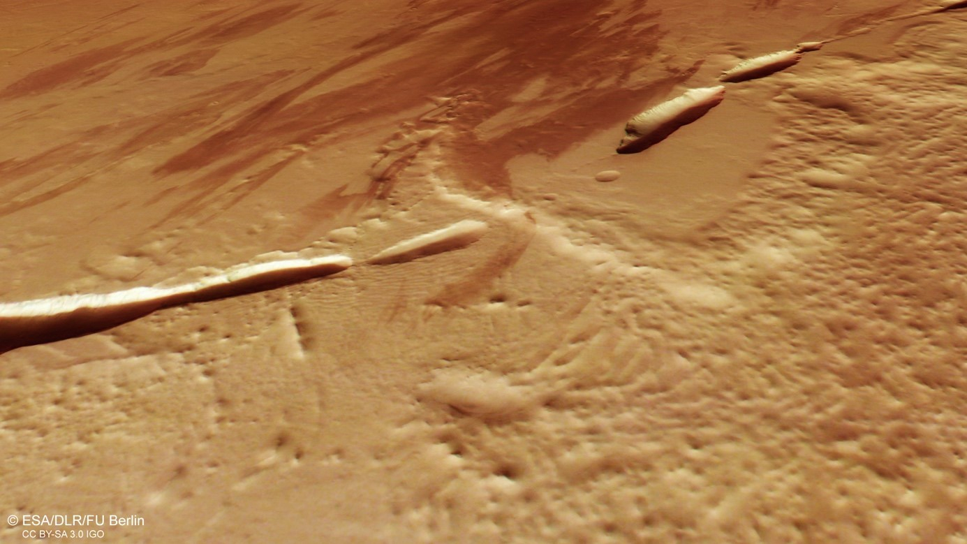
Plan view of Aganippe Fossa at the north-west foot of the Arsia Mons volcano
The top view shows an area at the edge of the north-western flank of the volcano Arsia Mons with a part of the 600 kilometre long rift structure Aganippe Fossa. Dark dust and sand deposits generate an unusual striated pattern on the surrounding surface. On closer inspection, lava flows can be recognised in the flat regions of the image (northern and right-hand sections). Arsia Mons is a huge shield volcano and the southernmost of the three Tharsis Montes volcanoes. With a base diameter of 435 kilometres, it rises more than nine kilometres above the surrounding plains.
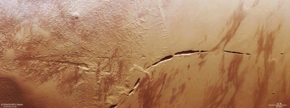
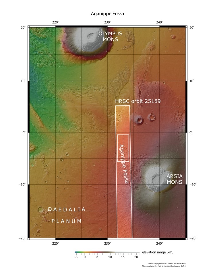
The approximately 240 by 100 kilometre image strip acquired by DLR's HRSC on board ESA's Mars Express spacecraft on 13 December 2023 during orbit 25189 covers an area between the equator and the eighth parallel south. Both the Arsia Mons volcano (south-east of the image strip) and the Olympus Mons volcano, the largest volcano in the Solar System, could have shaped the morphological structures in this region.
New image data from the German High Resolution Stereo Camera (HRSC) on board the Mars Express spacecraft show an area in the vicinity of the Arsia Mons volcano.
The reasons for the formation of the 'Aganippe Fossa' are still disputed among experts.
HRSC is a camera experiment developed and operated by the German Aerospace Center (DLR).
Focus: Space exploration, planetary research, Mars
The origin of the 'Aganippe Fossa' on Mars is the subject of intense debate among planetary researchers. The structure, named after a spring nymph in Greek mythology, puzzles even today's experts; some theories suggest that the trench is tectonic in origin, while others claim that volcanic veins formed during a late period of activity at the nearby Olympus Mons volcano, leading to the formation of the huge grabens.
New image data acquired by the High Resolution Stereo Camera (HRSC) on board ESA's Mars Express spacecraft show the northern part of Aganippe Fossa at the foot of the Arsia Mons volcano. HRSC is a camera system developed and operated by the German Aerospace Center (Deutsches Zentrum für Luft- und Raumfahrt; DLR).
The images show an area on the lower flank of Arsia Mons with a section of the large graben structure, Aganippe Fossa. Dark dust and sand deposits create an unusual striped pattern on the surface, and closer inspection of the flat regions of the image (on the north and right-hand sides) reveals a number of lava flows.
Enormous volcanoes with traces of ice
Arsia Mons is a giant 'shield volcano' and the southernmost of the three Tharsis Montes volcanoes. It measures 435 kilometres in diameter at the base and rises more than nine kilometres above the surrounding plains. Its summit caldera was formed when the magma chamber inside the volcano emptied and collapsed, and is the largest of all volcanoes on Mars in terms of volume, covering an area of almost 14,500 square kilometres – almost the size of the German state of Thuringia.
Arsia Mons also has what is known as an 'aureole'. These are extensive deposits left over by glaciers that once covered the foot of the mountain and, as with glaciers on Earth, slowly flowed down its slopes under the pressure of their own weight. Traces of former glaciation in the form of aureoles are a common feature of the Tharsis Montes. The Arsia Mons aureole covers more than 100,000 square kilometres – covering an area as large as Bavaria and Baden-Württemberg combined. However, the aureole only formed on the volcano's northwestern flank, perhaps due to gravitational and climate factors. The north-western side of the Tharsis volcanoes has a higher probability of landslides due to the combination of volcanic activity and the rotation of Mars, which can cause the volcanic slopes to be asymmetrically loaded, favouring landslides and the formation of aureoles.
Prevailing wind patterns on Mars may also play a role by preferentially transporting and depositing eroded material and pyroclastic deposits (from very hot explosions of molten rock and hot gases that rushed down the volcanic slopes at high speed) in a north-westerly direction, leading to the formation of the aureoles here. Two main characteristic features of the aureole can be seen in the image: a hilly terrain that forms the central part of the structure and an area of solidified flow structures that covers parts of the hilly terrain.
How did Aganippe Fossa form?
Aganippe Fossa is approximately 600 kilometres long, with the bounding graben walls standing three to seven kilometres apart. How it formed is still being debated: some theories suggest it has its origin in tectonics, formed by the volcanically induced expansion of the Martian crust. It could therefore be an isolated member of the Thaumasia Fossae, a group of grabens further south in the Tharsis region.
However, the formation of volcanic 'veins' in a late phase of Olympus Mons' activity could also have led to the formation of the giant dikes in the region.
On the other hand, the morphology – in other words, the appearance and shape – of the Aganippe Fossa suggests that these long depressions were formed by the collapse of underlying lava tubes. Such chain-like elongated collapse structures are typical in volcanic regions and form when the outer layers of a lava flow cool down. They solidify while the lava inside continues to flow through this 'insulation layer' and eventually drains away, creating a cavity, a bit like a tunnel. Over time, the 'roof' of the tunnel collapses and the partially tubular flow channel remains. This process often occurs in 'basic' lava flows with a low silicon content, which have a relatively low viscosity and can flow over long distances.
Image processing
The images were acquired by the HRSC (High Resolution Stereo Camera) on 13 December 2023 during Mars Express orbit number 25,189. The ground resolution is approximately 25 metres per pixel and the image is centred at about 233 degrees east and 3 degrees south. The colour image was created with data from the HRSC's nadir channel – the field of view oriented perpendicular to the Martian surface – along with the camera's colour channels.
The oblique perspective view was created from the digital terrain model (DTM) in tandem with the camera's nadir and colour channels. The anaglyph image, which conveys a three-dimensional impression of the landscape when viewed with red/blue or red/green glasses, was derived from the nadir channel and a stereo channel. The colour-coded view is based on a DTM of the region, from which the topography of the landscape can be derived. The reference body for the HRSC DTM is an equipotential surface of Mars (areoid).
HRSC is a camera experiment developed and operated by the German Aerospace Center (Deutsches Zentrum für Luft- und Raumfahrt; DLR). Systematic processing of the camera data was carried out at the DLR Institute of Planetary Research in Berlin-Adlershof. The Planetary Sciences and Remote Sensing Working Group at the Freie Universität Berlin used the data to create the image products shown here.
Map server
To download the released raw images and DTMs of the region in GIS-compatible formats, follow this link to the map server.
The High Resolution Stereo (HRSC) was developed at the German Aerospace Center (DLR) and built in cooperation with industrial partners (EADS Astrium, Lewicki Microelectronic GmbH and Jena-Optronik GmbH). The science team, led by Principal Investigator (PI) Daniela Tirsch from the DLR Institute of Planetary Research, consists of 52 co-investigators from 34 institutions and 11 nations. The camera is operated by the DLR Institute of Planetary Research in Berlin-Adlershof.

