Mawrth Vallis region – the deepest clay deposits on Mars
July 21, 2023 | Mars Express mission
Mawrth Vallis region – the deepest clay deposits on Mars
In the west of the Mawrth Vallis outflow
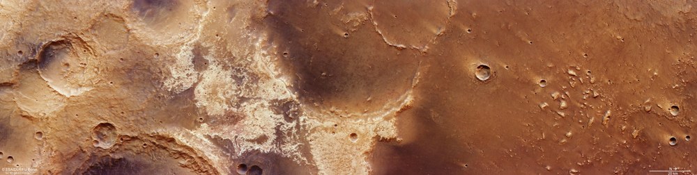
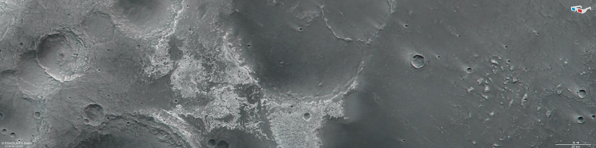
At approximately 25 degrees north, Mawrth Vallis, located in western Arabia Terra, ends and flows into Chryse Planitia at the boundary between the Martian highlands and lowlands. Spacecraft such as ESA's Mars Express and NASA's Mars Odyssey and Mars Reconnaissance Orbiter have discovered clay minerals there with their spectrometers, which can be seen in this image created using data acquired by DLR's HRSC instrument as light-coloured deposits that are up to 200 metres deep. North, with the Martian lowlands is on the right in this image, while the Martian highlands with their large, old impact craters are on the left. The region shown covers an area of 335 kilometres by 84 kilometres and, at 28,000 square kilometres, is a little smaller than the German state of Brandenburg.
Hydrous clay minerals in the west of Mawrth Vallis
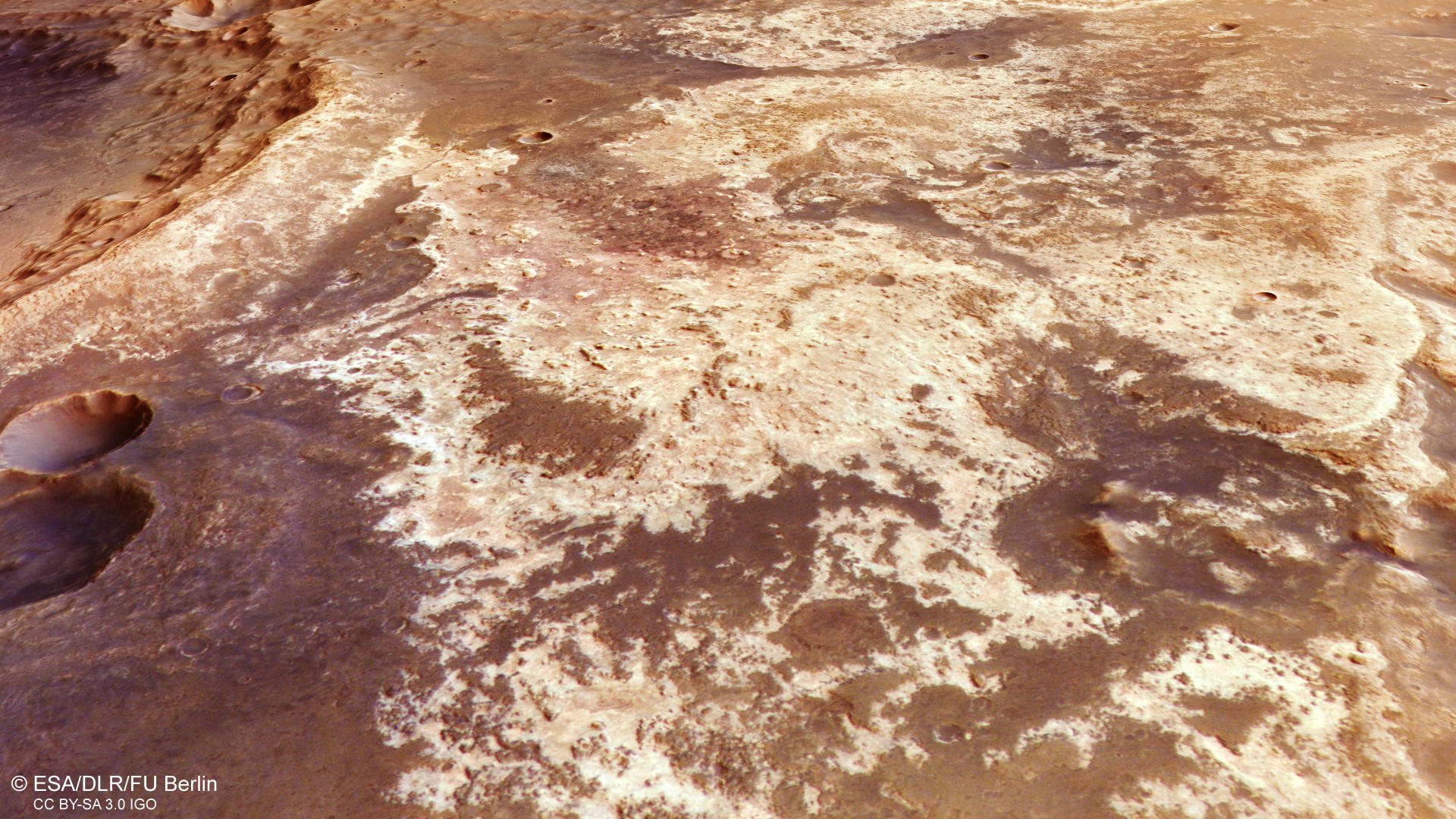
Light and dark coloured deposits are found in and around the Mawrth Vallis outflow. The light-coloured materials in particular are an indication of the previous presence of water. On Earth, such clay minerals are often formed as a weathering product of volcanic rocks that come into contact with water over long periods of time and are thus transformed. The region is considered one of the most promising locations to search for fossil or even present-day life on the Red Planet but has not yet been selected as the landing site for a mission due to its difficult terrain.
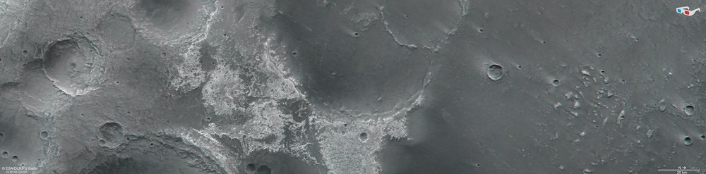
Anaglyph images can be generated using data acquired by the nadir channel of the High Resolution Stereo Camera (HRSC) on ESA's Mars Express spacecraft, which is directed perpendicularly onto the surface of Mars, and one of the four oblique-viewing stereo channels. When used with red-blue or red-green glasses, they allow a three-dimensional view of the landscape and give the viewer a spatial idea of the differences in altitude. When viewed in this way, the transition from the Martian highlands in the south (left half of the image) to the northern lowlands (right half of the image) is particularly striking. In also enables many topographical details to be seen at the edges of the various impact craters.
Clay minerals are clear evidence of the previous presence of water on Mars.
In Mawrth Vallis and its surroundings, layers of clay minerals up to 200 metres deep can be found.
Astrobiologists believe there is a possibility of finding fossils or traces of surviving life in these areas on Mars.
Focus: Space, Mars, planetary research, Mars Express mission
New images, created using data acquired by the German Aerospace Center (Deutsches Zentrum für Luft- und Raumfahrt; DLR) High Resolution Stereo Camera (HRSC) on board ESA's Mars Express spacecraft, show part of the dried-up Mawrth Vallis river valley. This is one of the largest and oldest valleys on Mars, where light-coloured clay deposits up to 200 metres deep can be found in numerous places. Clays belong to the class of phyllosilicate minerals and are clear evidence of the action of liquid water on the surface, as water is essential for their formation. Therefore, this region is considered one of the most promising places to search for past or even present life on Mars.
Enormous Martian valley once again the focus for HRSC
On 18 February 2023, Mars Express made a repeat flyover of the Mawrth Vallis region, one of the most distinctive and fascinating regions of the Red Planet, which is also of the greatest scientific interest. 'Mawrth' is the Welsh name for Mars. The image data were acquired 130 kilometres west of the outflow of Mawrth Vallis. Repeated imaging coverage at different times makes it possible to observe changes on the surface of Mars. Often, clouds or dust in the atmosphere cause variations in image quality, especially in this region at the transition between the southern highland regions and the northern lowlands of Mars, referred to as the highland-lowland or dichotomy boundary. Another reason for repeat observations is to obtain additional surface data for creating and improving terrain models and image mosaics. A large mosaic of this region was created in 2016, as was an animation showing an overflight of the region.
Science fiction fans also know Mawrth Vallis as the location of the more than one-thousand-kilometre route followed by astronaut Mark Watney while stranded on Mars, in the novel 'The Martian' by Andy Weir. This book was later also filmed. In the end, Watney reached the rescue rocket Ares 4 in Schiaparelli Crater, which is located a little further southeast in Arabia Terra. In 2015, the DLR Institute of Planetary Research recreated this route with HRSC image data and computed a spectacular animation using digital terrain models derived from HRSC data. This video was shown in German-language cinemas as the opening credits to 'The Martian'.
Was Mawrth Vallis once a place suitable for life?
Although the region is considered one of the most promising locations to search for fossil or even present-day life on the Red Planet, it has not yet been selected as the landing site for a mission due to its difficult topography, as landings on steep terrain are hazardous. Light and dark coloured deposits are found in and around the Mawrth Vallis outflow. The light-coloured materials in particular are an indication of the previous presence of water. The largest deposits of hydrous phyllosilicates on Mars exist in and near Mawrth Vallis, forming deposits up to 200 metres deep in some places.
On Earth, such clay minerals often form as a weathering product of volcanic rocks that come into contact with water over long periods of time and are thus transformed. Therefore, an analogous formation process for these minerals is thought to have taken place on Mars. Spectrometer data were used to identify, among others, the smectite clay minerals nontronite and saponite, in whose crystal framework of silicon tetrahedra, in addition to aluminium and magnesium cations, 'water molecules' (hydroxyl ions, OH-) are also 'incorporated'.
Above the clays lies a dark stratum of rock that is thought to be of volcanic origin. Investigations with the Observatoire pour la Minéralogie, l'Eau, les Glaces et l'Activité (OMEGA) spectrometer, also carried on board Mars Express, led to a better understanding of the iron-, magnesium- and aluminium-rich clay minerals. The different compositions of these clays testify to the different ages and degrees of weathering of the individual deposits. Sulphate-bearing deposits were also found on the floor of Mawrth Vallis, again indicating a different formation environment.
In addition to mineralogy, the large-scale stratification of the light-coloured rocks offers a unique opportunity to decipher the depositional conditions and the climatic history of Mars. The layered silicates on Mars could indicate surface weathering as a result of the action of water and therefore an environment that was potentially suitable for life in the past. Water once flowed through Mawrth Vallis and probably shaped the surface until 3.6 billion years ago. It is therefore possible that fossil traces of microbes have been preserved in the rocks, having been protected from destruction by radiation and erosion by the overlying rock layers. Astrobiologists have long been interested in this region of Mars.
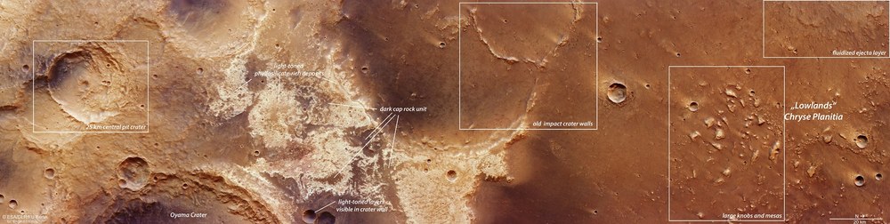
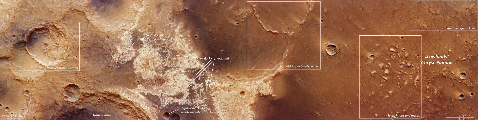
Geological structures in the outflow area of Mawrth Vallis
This image shows the locations of the geological features described in the text. From left to right (from south to north) – a 25-kilometre crater with a central pit-like depression that could be due to a water vapour explosion (25 km central pit crater); old, cratered Martian highlands ('Highlands', old and cratered); light-toned phyllosilicate-rich deposits; light-toned layers visible in crater wall; dark cap rock unit; old impact crater walls; large knobs and mesas; 'Lowlands' Chryse Planitia; fluidized ejecta layer.
The 25-kilometre-wide impact crater on the far left in images 1, 6 and 7 has a depression or pit in its centre, whose northern wall has partially collapsed. Such 'central pit craters' are impact craters that often occur on Mars, due to its subsurface ice layers, and on ice-rich moons. The raised rims around the central pit strongly suggest that it was formed by a water vapour explosion.
Further to the right (north) in the images are large areas of light-coloured, clay-like materials. On closer inspection, they can also be found within the crater walls, for example in the smaller crater in the lower part of the images. The dark, volcanic overlying rock can also be seen in places, but is often heavily eroded. Further north, the terrain drops steeply, by more than a thousand metres into the lowland of Chryse Planitia. Two interconnected, old and heavily eroded impact craters are just visible in the plain (centre of image 1 and in perspective view, image 4). The larger one is approximately 75 kilometres across, while the smaller one is about 35 kilometres in diameter, – slightly larger than the 25-kilometre-wide Nördlinger Ries, an impact crater on Earth, located in Germany on the border between Württemberg and Bavaria.
Further north is a field with numerous mesas protruding from an otherwise flat plain: the larger mesas are up to three kilometres across and interpreted as remnants of a former, now eroded highland plain. Finally, in the upper right corner of the images, part of a 'fluidised' ejecta blanket can be seen. This is the result of an impact into a surface that contained subsurface water or ice. According to the prevailing model of Martian history, the ground ice was melted by the high impact energy. During such an impact, hundreds of thousands of tonnes of a mixture of water, rock and debris reach the surface and form these lobate ejecta blankets around the crater. These are characteristic of Mars and resemble mobilised mud.
Image processing
The images were created using data acquired by the High Resolution Stereo Camera (HRSC) on 18 February 2023 during Mars Express orbit 24,164. The ground resolution is approximately 18 metres per pixel. The images are centred at 339 degrees east and 25 degrees north. The colour image was created using data from the nadir channel, the field of view of which oriented perpendicular to the surface of Mars, and the colour channels. The oblique perspective views were created using a Digital Terrain Model (DTM) and data from the nadir channel and the colour channels. The anaglyph image, which gives a three-dimensional impression of the landscape when viewed with red/blue or red/green glasses, was derived using data from the nadir channel and one of the stereo channels. The colour-coded topographic view is based on a DTM of the region, from which the topography of the landscape can be derived. The reference body for the HRSC-DTM is a Martian equipotential surface (areoid).
HRSC is a camera experiment developed and operated by the German Aerospace Center (DLR). The systematic evaluation of the camera data was carried out at the DLR Institute of Planetary Research in Berlin-Adlershof. Personnel in the Department of Planetary Sciences and Remote Sensing at the Freie Universität Berlin used these data to create the image products shown here.
The High Resolution Stereo Camera (HRSC) was developed at the German Aerospace Center (DLR) and built in cooperation with industrial partners (EADS Astrium, Lewicki Microelectronic GmbH and Jena-Optronik GmbH). The science team, led by Principal Investigator (PI) Thomas Roatsch of the DLR Institute of Planetary Research, consists of 50 co-investigators from 35 institutions and 10 nations. The camera is operated by the DLR Institute of Planetary Research in Berlin-Adlershof.

