
Digitisation in agriculture — Field testing DLR technologies
Remote sensing data can be useful in agriculture for increasing productivity while protecting the environment and biodiversity. In the "AgriSens DEMMIN 4.0 – Remote sensing technologies for digitisation in plant cultivation" project, the German Aerospace Center (DLR) is assessing remote sensing technologies suitable for digitisation applications in the agriculture sector through regional field testing at an experimental site in Mecklenburg-Vorpommern.


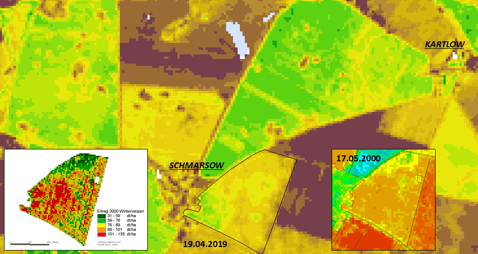
"The focus is primarily on testing technologies for applications that can in the future assist farmers to estimate crop yield, identify areas with lower yields, and assess soil moisture," explains Prof. Erik Borg of the German Remote Sensing Data Center in Neustrelitz. Geodata collected by remote sensing sensors mounted on satellites or drones are employed for this purpose.
The test field is about 220 kilometres north of Berlin near the city of Demmin and well suited for this project because it is intensively used for agriculture. "The "DEMMIN" text field has existed for 20 years and was established especially for testing remote sensing methodologies. In particular, the varied landscape found here makes it possible for us to develop and test at reasonable cost a wide range of remote sensing applications on a relatively limited area under different constraints", Borg further explains. "Already the pixel resolution of the sensors poses a challenge for agricultural applications. Digitisation in agriculture should help reduce the cost of obtaining data and information as well as improve the consultation services based on them."
DLR provides the science foundation
In the "AgriSens DEMMIN 4.0" project, scientists from various DLR institutes combine their expertise. These include the German Remote Sensing Data Center's departments "Land Surface Dynamics" and "National Ground Segment" and the Institute of Data Science, founded in 2017, with its "Citizen Science " department. The German Remote Sensing Data Center supplies the satellite data that form the basis for crop monitoring. "For the DEMMIN test areas our earth observation time series and information layers can be compared with the in situ measures collected by our project partners, which makes it possible to provide high-quality information", explains Dr. Sarah Asam of the Land Surface Dynamics department. Together with scientists from DLR's Citizen Science department and Friedrich Schiller University (FSU) in Jena, citizen science strategies are developed that involve agricultural stakeholders in the data collection. Sina Truckenbrodt of FSU Jena elucidates, "Farmers have very detailed local knowledge and a wealth of extensive experience in cultivating their arable acreage. In light of the increasing lack of people with expertise it is crucial to preserve and pass on this knowledge. So together with farmers we want to develop digital maps and recommendations for action in order to assure easy access to existing knowledge." For example, local knowledge for mapping low-yield acreage is to be collected and combined with information from earth observation satellite time series and made available to farmers in the form of information products. "By combining expertise from the three complementary research fields of remote sensing, data science and citizen science, the AgriSens DEMMIN 4.0 projects makes it possible to develop and test innovative agricultural technologies. Because of long and trusted collaboration with the Remote Sensing Data Center and Friedrich Schiller University we have in DEMMIN particularly good prerequisites for actively involving farmers in timely collection strategies" says Friederike Klan of the Institute of Data Science in Jena.
Making low-threshold offers for the agriculture sector
The project goal is to provide farmers with data sets they can consult to obtain information important for their work. Such information serves as a basis for decisions relating to fertilizing, sowing and soil cultivation. "At present the hurdles to using these data are unfortunately much too high for many farmers. This applies above all to accessing the data and using it in a multitude of software solutions and confusing market offerings. We intend to offer low-threshold solutions" assures Dr. Daniel Spengler, project coordinator, spokesman for the test field, and scientist at GeoForschungsZentrum (GFZ) Potsdam.
Science and agriculture alliance
The AgriSens DEMMIN 4.0 research association is composed of the German Research Centre for Geosciences (GFZ) Potsdam, the German Aerospace Center (DLR), the Julius Kühn Institute Braunschweig, the Deutschen Wetterdienst (Germany's national meteorological service), Martin Luther University Halle-Wittenberg, Friedrich Schiller University Jena, Julius Maximilian University Würzburg, and Neubrandenburg University of Applied Sciences. The participants from the agricultural sector include regional agricultural enterprises in the Demmin area of Mecklenburg-Western Pomerania and partner companies of the participating research institutes throughout Germany. Interested agricultural stakeholders still have the opportunity to join the project.
On 9 March 2020 Federal Minister of Food and Agriculture Julia Klöckner presented the funding confirmation for the AgriSens DEMMIN 4.0 project. DLR's contribution is supported with a project grant of 1.04 million euro (Grant identification number 28DE114C18).
