
DLR instrument DESIS on ISS supports new Copernicus mission

Since May 2020 the imaging spectrometer DESIS on ISS (the International Space Station) has been recording additional data in preparation of the hyperspectral Copernicus mission CHIME. As an important component of Europe's Sentinel fleet CHIME will in future regularly record hyperspectral data from Earth's entire surface.
DESIS data are being used to prepare for the development and testing of new earth observation products relating to the CHIME mission. DESIS records radiation reflected from Earth's surface in 235 spectral channels. This makes it possible to precisely characterise the geophysical and biophysical properties of Earth's various surfaces. For example, the resulting data products will contain information about the stress and photosynthetic output of plants, and make it possible to evaluate the fertility and fertiliser requirements of soils as well as estimate the character and degree of water body eutrophication. Insights gained from the preparatory activities will also be crucial for EnMAP, Germany's first hyperspectral mission, now forthcoming.

Another goal is to estimate the volume of data expected from the future hyperspectral Sentinel mission CHIME. It will considerably exceed that coming from the multispectral Sentinel-2 mission, in operation since 2015. Sentinel-2 records Earth's surface in 14 different spectral channels, whereas over 200 will be recorded in the CHIME mission. The anticipated data volume poses a challenge for data transfer as well as for data processing and storage, which requires new, intelligent technologies.
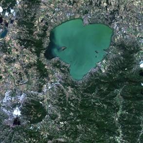
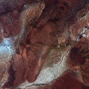
The international science advisory committee for the CHIME mission has selected 25 European test sites for this purpose. They include agriculturally used marginal soils in the Camarena region as well as the ecologically important Aznalcóllar wetland in Spain, the national parks Bayerischer Wald and Hunsrück in Germany, as well as Lake Trasimeno in Italy. The scientists will regularly sample these and other test sites in ground measurement campaigns and with recordings from AVIRIS-NG, an airborne US hyperspectral instrument (JPL/NASA). The preparatory activities will also be supported by the Italian hyperspectral mission PRISMA, in orbit since spring 2019 and since May 2020 likewise providing data for the international science community.
The German-US DESIS mission has been recording hyperspectral data from Earth's surface since September 2018 and is making it possible for scientists to gain new insights about the material characteristics of Earth's surface. The associated “Announcement of Opportunity” is intended to initiate basic and applied research as well as the development and demonstration of future operational hyperspectral applications and missions. The “Announcement of Opportunity” specifies a limited data contingent for all approved proposals, free of charge until the mission ends. Detailed information on accessing DESIS can be found via the links in the navigation bar on the left.
DESIS is jointly operated by the German Aerospace Center (DLR) and Teledyne Brown Engineering (TBE). The US company has developed and installed on ISS a flexible “Multi-User-System for Earth Sensing” (MUSES) platform on which the push-broom imaging-spectrometer DESIS, developed and constructed by DLR, is mounted.