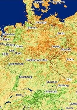
Satellite instruments that record in the visible and near infrared range of the electromagnetic spectrum provide information on vegetation vitality.
Comparison of the present situation with the average value for the past 18 years clearly shows the effects of the current drought on the vegetation cover in northern and eastern Germany. The map shows vegetation anomalies recorded with the MODIS (Moderate Resolution Imaging Spectroradiometer) sensor.
Recent weeks of heat and aridity have dried out soil and vegetation in northern and eastern Germany. In some regions the lowest precipitation levels in 50 years have been measured. EOC time series analyses document the extent of the drought.
Satellite data time series covering many years allow comparison of this year’s situation with previous years. The analysis makes visible differences from the mean value of the past 18 years. Areas in which the vegetation was less robust in June 2018 are shown in brown tones. Areas where there was more photosynthetic activity in the vegetation cover compared with the long-term mean value appear in green tones. Especially the northern and eastern parts of Germany greatly suffer from the continued dryness.
Already in April and May this year high temperatures in Germany made headlines. The absence of precipitation in June and July then led to drought in the affected regions, with many negative consequences. Agriculture is particularly affected. In large parts of Germany harvesting has to take place earlier than usual this year and lower yields are anticipated because of the rainfall deficit.
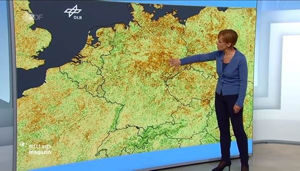
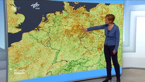
Presentation of the DFD analysis on dryness in Germany in the ZDF Mittagsmagazin broadcast on Thursday, 12 July 2018.

