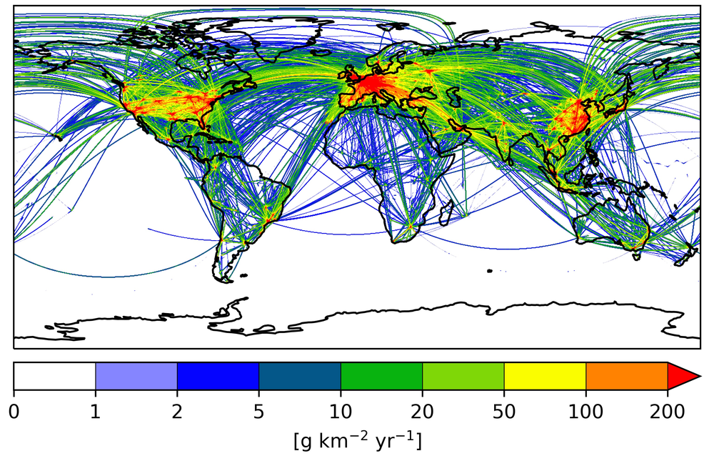
Global emissions of soot from the aviation sector in the year 2015.
In the ELK project, global emission data for different species and for land transport, shipping, aviation and the related energy and industry sectors will be developed.
Transport and the related economic sectors contribute significantly to climate change. The emissions from these sectors are continuously growing, challenging the achievement of the Paris agreement. These sectors also have detrimental impacts on air quality and noise pollution.
None of the currently available emission inventories can consistently account for the emissions (gas, particles and noise) of all transport modes (land transport, aviation and shipping), while also considering the emissions from transport-related energy production, industrial processes and infrastructures. Moreover, the available inventories do not include information at subsector level, for example, they neither distinguish among different vehicle types nor consider key transport-related quantities other than emissions. However, emission inventories at such a level of detail are essential for a reliable quantification of the impact of transport at national, regional, and global scales. In addition, consistent emissions inventories are required for the development of future emissions scenarios to assess the effectiveness of climate policies and other measures to improve air quality and to reduce noise pollution.
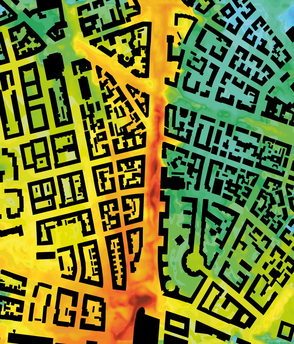
NO2 concentrations in München.
1 km x 1 km domain nearby Landshuter Allee and Nymphenburger Straße simulated with PALM-4U LES model. In the ELK project, building- and turbulence-resolving simulations of NO2 in Hamburg will be performed.
To master this challenging task, the strategic impulse project EmissionsLandKarte (ELK) co-led by the Institute of Atmospheric Physics (Oberpfaffenhofen) and the Institute of Transport Research (Berlin) combines the interdisciplinary expertise of DLR through a collaboration of 25 Institutes and the external collaborator HEREON. ELK aims to establish a primary source of information for different stakeholders and working groups, such as national policy makers, the scientific community dealing with climate, air quality and noise modelling, and the Intergovernmental Panel for Climate Change (IPCC).
A collaborative and interdisciplinary approach is necessary in order to cover the wide spectrum of topics inherent to the compilation of emission inventories. This includes, for instance, transport demand, emission indices, and the development of models, together with dedicated methods for data visualization and management. The diversity of data sources and the heterogeneity of data formats from different sectors and data providers require the combination of different modelling tools and approaches, along with the use of measurements and satellite data.
Available DLR data as well as data from external providers will be processed and used as input data to quantify spatially and temporally resolved transport volumes and emission distributions. Based on already available inventories, precise criteria for the design of the ELK emission inventories will be defined and their quality and usability in real-world applications will be checked. Finally, a database structure and user interface will be established to guarantee an easy and reliable access to the final products for both internal and external users.
The ELK project links the aeronautics, space, transport and energy research programs of the DLR.
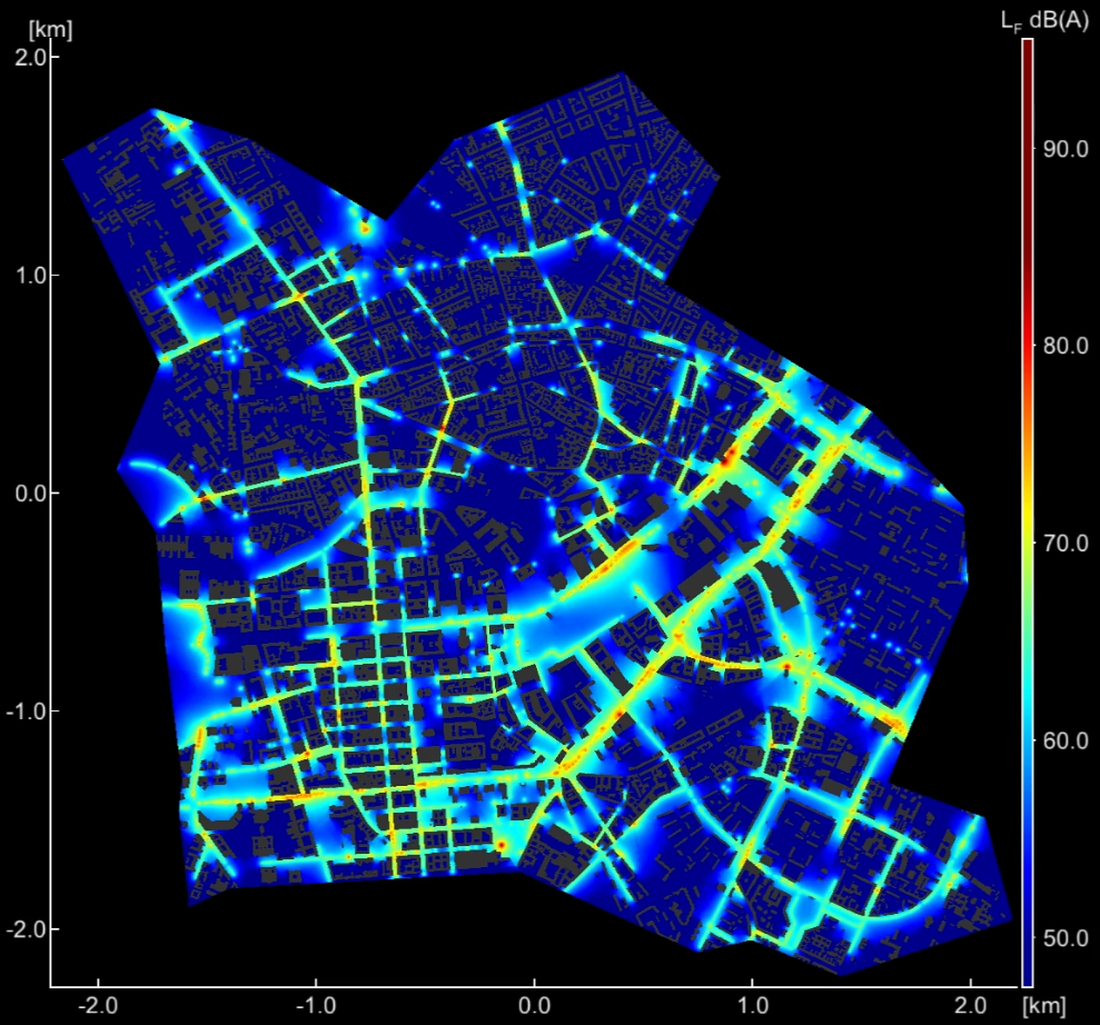
Simulation of road traffic noise in the Berlin-Mitte district.
In the ELK project, highly resolved noise maps for the city of Hamburg will be provided.


