DLR takes a closer look at global CO 2 emissions with a dedicated mission
June 29, 2022
DLR takes a closer look at global CO 2 emissions with a dedicated mission
DLR scientists presented the “CO2Image” demonstrator mission at the International Aerospace Exhibition in Berlin (ILA, June 21 - 26, 2022). The goal of the mission is to precisely measure emissions of the greenhouse gases carbon dioxide and methane from so-called "point sources" (e.g. power plants, industrial facilities, coal mines). Currently, about 30% of fossil CO2 emissions are released from such point sources, primarily from coal-fired power plants, but also from industrial facilities. Figure 1 shows the spatial distribution of these emissions, as well as their magnitude. Based on the measurement capabilities of the currently planned satellite missions (e.g. CO2M), about a quarter of these point-source emissions will be detectable from space. In contrast, the technique demonstrated by CO2Image would be able to measure about 90% of these emissions (Strandgren et al., 2020).
Figure 1: Left panel: Geographic distribution of estimated annual CO2 emissions from power plants worldwide (CARMA database). Right panel: The cumulative distribution of the same CO2 emissions. It can be seen that about 64% of these emissions come from medium-sized power plants (with emissions of 1-10 MtCO2 per year). (Images: Strandgren et al.)
The Institute of Atmospheric Physics (IPA) leads the scientific side of the mission, and is working with the University of Heidelberg to answer various research questions in preparation for CO2Image. One of the current research tasks is to develop methods to determine the emissions from images of CO2 plumes with the best possible accuracy. The DLR Institute of Optical Sensor Systems (OS) is developing an imaging spectrometer for the mission, specifically designed for such point source measurements. The instrument, called COSIS, is scheduled for launch in 2026 as the mission's main payload. The DLR Earth Observation Center (EOC) is in charge of processing the scientific data and calibrating the instrument.
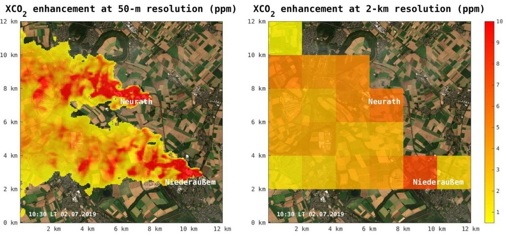
The CO2Image mission, currently in Phase B, complements current and planned Copernicus missions such as Sentinel-5p and CO2M. Current instruments typically have a spatial resolution of a few kilometers and are able to measure greenhouse gas concentrations in the Earth's atmosphere with high precision and broad spatial coverage. CO2Image will work in concert with these missions, acting as a sort of magnifying glass – measuring emissions from small and medium-sized point sources that global survey missions cannot resolve. This is accomplished through a novel instrument design with a comparatively high spatial resolution of 50 meters. Figure 2 illustrates the impact of this difference in spatial resolution using emissions from the Neurath and Niederaußem power plants as an example. This is a decisive advantage in the detection of emissions from CO2 point sources: The concentration enhancement per pixel is many times higher, since the CO2 signal is only averaged over a small area, and is thus much easier to measure. In addition, the high spatial resolution enables the separation of emissions from point sources in close proximity to one another.
Figure 2: Model simulation of total-column CO2 enhancement (in ppm) for the Neurath and Niederaußem power plants (Germany). Left: Spatial resolution of 50 m x 50 m (CO2Image). Right: spatial resolution of 2 km x 2 km (e.g. CO2M). Copernicus Sentinel data 2019 were used for the background image. Graphics: DLR / J. Marshall (CC BY-ND-NC 3.0).
Mitigating human-induced climate change is one of the greatest societal and technological challenges of our time. To limit the global temperature increase to 1.5 or 2°C, as targeted in the Paris Climate Accord, a significant reduction in carbon dioxide emissions is necessary. Upon successful demonstration of the CO2Image concept, the compact and cost-effective instrument design could be deployed in constellation or as a secondary payload in the future, providing a valuable contribution to independently assess CO2 emissions and the efficacy of mitigation efforts.