The BOLIDE experiment built by the Institute of Atmospheric Physics was the first lidar to fly on a stratospheric balloon. The long duration balloon was launched at July 8th, 2018 at 7:27 UTC from Kiruna, Sweden, during NASA’s summer campaign. From a floating altitude of 39 km, measurements were taken of the atmosphere above. Almost six days later the gondola landed safely in Nunavut, Canada.
The PMC-Turbo payload hanging on the HERCULES launch vehicle. The 240 m long flight train including the parachute and balloon is laid out to the right
NASA’s PMC-Turbo mission is dedicated to the research of noctilucent clouds. Noctilucent clouds consist of tiny ice particles that form at 83 km altitude during polar summer. The silvery-white clouds at the edge of space, first observed in 1885, are fascinating and scientists use them to study dynamical processes in this far-away region that is otherwise hard to observe.
Ascent of PMC-Turbo (left) and PMC-Turbo in flight (right, photograph by Mats Erikson from Kiruna)
A balloon-borne measurement platform is ideal for high-resolution measurements of noctilucent clouds. The dense atmosphere with its tropospheric clouds, that often block the view of noctilucent clouds, stays far below the floating altitude of the balloon. At this high altitude, the sky appears black and thus provides optimalobserving condition for optical instruments. Only a rocket comes closer to noctilucent clouds, but only for a few seconds.
View of the west coast of Greenland with the BOLIDE receiving telescope in the foreground
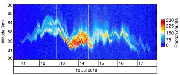
On board the PMC-turbo payload were seven NASA-funded high-resolution cameras with wide and narrow field of views which are used to assess the spatial structure of noctilucent clouds. The BOLIDE lidar sends laser pulses towards them. The backscattered photons allow for precise sounding of the vertical structure of noctilucent clouds. For example, the ice layer may be dim but more than five kilometers thick, or with only 100 m vertical extent very narrow and very bright. Sometimes multiple layers are observed. The slow motion of the balloon allows for mapping of the spatial structure of the ice layers. This way, wave motions induced by atmospheric gravity waves and turbulence processes become visible. In conjunction with the set of camera images this dataset is unique. It will be analyzed in combination with high-resolution model simulations.
Seven-hour measurement of a noctilucent cloud above Baffin Island, Canada