
Greenland and the European Weather
DLR

DLR
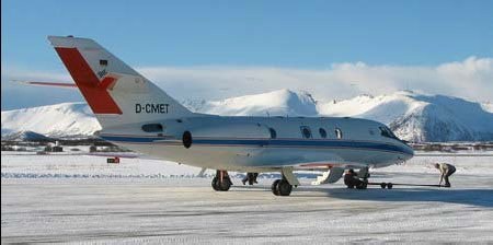
In the framework of the International Polar Year, scientists of the DLR Institute of Atmospheric Physics performed airborne observations between Greenland and Svalbard. The focus of their 3 weeks endeavor in February/March 2008 was to investigate the generation, structure and development of Arctic storms. Currently, the unique data gathered at theses remote places are analyzed to study their impact on the forecast skill of state-of-the-art weather prediction models. The results will be finally used to improve current forecasts schemes for high-impact weather events in Europe and, especially, in the Arctic regions.
This work is part of the IPY-THORPEX cluster and it is partially supported by the University of Oslo (Norway), the European Fleet for Airborne Research (EUFAR) and the DLR Institute of Atmospheric Physics. The observations were performed with the DLR research aircraft FALCON which was based on Andøya (Vesterålen, Norwegen) during IPY-THORPEX. The DLR FALCON was equipped with a new generation of remote-sensing instruments: the newly developed multi-wavelength Differential Absorption LIDAR (DIAL) WALES which measured tropospheric aerosols and for the very first time water vapor with four different wavelengths. Additionally, the 2μm-Doppler-LIDAR provided simultaneous wind profiles below the aircraft. The multi-wavelength DIAL WALES is a predecessor instrument for future space missions.