Glacial melting increases freshwater loss and accelerates sea level rise
February 19, 2025
Glacial melting increases freshwater loss and accelerates sea level rise
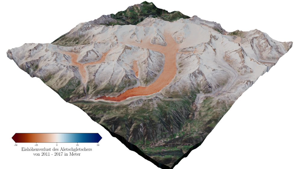
Elevation change of Grosser Aletschgletscher between 2011 and 2017
This TanDEM-X elevation difference image shows the change in height, or ice loss, of Grosser Aletschgletscher (Switzerland) between 2011 and 2017. The highly accurate radar data reveals losses of up to 50 metres in ice height, marked here in shades of red.
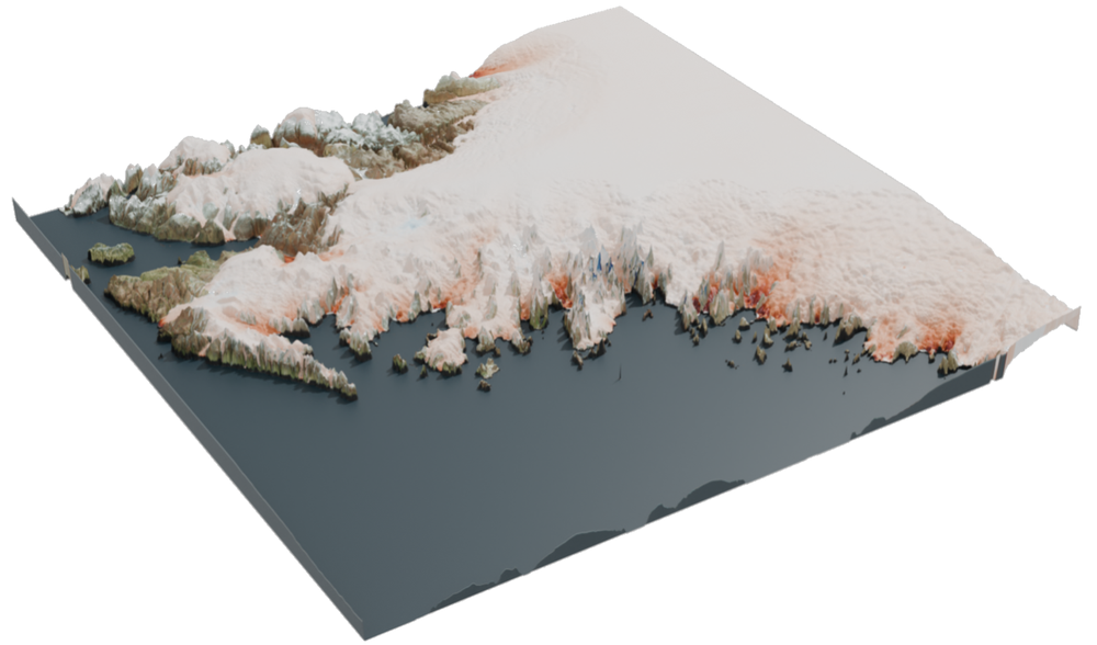
Elevation change of the Greenland Ice Sheet between 2011 and 2017
Using TanDEM-X data, an elevation difference image was created that illustrates the change in elevation of the Greenland Ice Sheet. The peripheral glaciers along the northwest coast of Greenland were observed between 2011 and 2017. Losses in ice height are visible in shades of red, with darker shades indicating greater losses. According to radar data, the glaciers here have lost up to 50 metres in height.
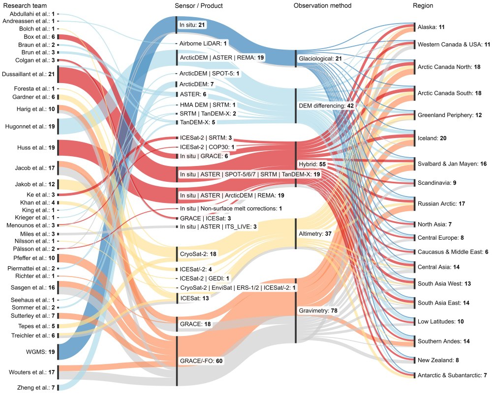
Overview of data compilation from 35 research teams
This figure provides an overview of research teams participating in GlaMBIE (left, in alphabetical order), along with their selection of sensors or products (middle left) used for computing glacier mass-change estimates from different observation methods (middle right) for the 19 studied regions (right). From the 233 regional results, 195 were used to compute combined estimates (coloured lines), and 38 were excluded based on regional confidence levels of observation methods (grey lines). Colours follow observation methods. The figure was created using SankeyMATIC (https://sankeymatic.com/build/).
Image: 3/3, Credit:
The GlaMBIE Team (2025). Nature.
Glaciers worldwide are losing an average of 273 billion tonnes of ice per year.
This average figure masks a significant acceleration of ice loss over the past decade.
The DLR satellite mission TanDEM-X contributes its unique dataset to this research and is indispensable for climate studies.
Focus: Space, Earth observation, climate impact research
The melting of glacial ice around the world is reducing regional freshwater supplies and contributing to the ongoing rise in global sea levels. A new study, conducted as part of the Glacier Mass Balance Intercomparison Exercise (GlaMBIE), was published in Nature on 19 February 2025, and sheds new light on this issue. The German Aerospace Center (Deutsche Zentrum für Luft- und Raumfahrt; DLR) was one of 35 international research teams participating in GlaMBIE.
Glaciers worldwide are losing 273 billion tonnes of ice per year
In the year 2000, glaciers covered more than 705,221 square kilometres and contained an estimated 121,728 billion tonnes of ice. Since then, they have lost an average 273 billion tonnes of ice every year. However, this average figure conceals a significant and alarming increase in the rate of ice loss over the past decade. These are the results of the recent GLaMBIE study, the focus of which was on predefined glacier regions that are particularly vulnerable due to their size and geographical position and therefore melt more rapidly. As such, the study does not include the continental ice sheets of Greenland and Antarctica.
Over the past two decades, the glaciers studied within GlaMBIE have lost approximately five percent of their total volume globally. Relative regional losses vary widely, ranging from two percent in the Antarctic and sub-Antarctic islands to 39 percent in Central Europe. This corresponds to an annual loss of 273 billion tonnes of ice. The study also reveals that small glacier regions, such as those in Central Europe, are losing a greater proportion of their ice mass than large glacier regions. Regions smaller than 15,000 square kilometres are particularly vulnerable to global warming. The long-term trend is also striking: In the second half of the study period (2012–2023), the rate of ice loss increased by 36 percent compared to the first half (2000–2011). In absolute terms, the annual average loss rose from 231 billion tonnes to 314 billion tonnes after 2012.
"At the DLR Earth Observation Center, we analysed more than 5000 TanDEM-X datasets to support the joint estimate of ice loss from Greenland’s peripheral glaciers. For our second key region, the Southern Andes, we used our TanDEM-X-based mass changes of the Patagonian Ice Fields up to 2016, and extended them across the entire region," explains co-author Dana Floricioiu from DLR’s Earth Observation Center (EOC).
The German radar satellite duo TerraSAR-X and TanDEM-X capture high-resolution 2D and 3D images, independent of weather conditions and daylight. This makes them particularly valuable for monitoring changes on Earth's surface. With each satellite flyover, they continuously document developments in glaciers and ice sheets, expanding the vital dataset required for researchers and policymakers worldwide. Notably, the TanDEM-X mission has provided the most comprehensive and accurate mapping of Greenland and Antarctica to date. Additionally, the two radar satellites supply high-quality data for a wide range of applications in scientific, commercial and security sectors.
Combining different data sources to determine the global glacier mass distribution
The GlaMBIE team coordinated the compilation, standardisation and analysis of diverse datasets, including field measurements and a wide range of optical, radar, laser and gravimetric satellite missions. Satellite observations included data from the US Terra/ASTER and ICESat-2 missions, the US-German GRACE mission, the German Earth observation mission TanDEM-X and ESA's CryoSat mission. The common goal was to estimate global glacier mass loss, and by integrating various types of data from these multiple sources, GlaMBIE developed an annual time series of mass changes for all glacier regions worldwide, covering the period from 2000 to 2023.
"We compiled 233 estimates of regional glacier mass changes from approximately 450 data providers, organised into 35 research teams," explains Michael Zemp from the University of Zurich, who co-led the study. "Benefiting from the different observation methods, GlaMBIE not only provides new insights into regional trends and year-to-year variability, but we could also identify differences among observation methods. This means that we can provide a new observational baseline for future studies on the impact of glacier melt on regional water availability and global sea-level rise."
Regarding the regions investigated by DLR, co-author Sahra Abdullahi says: "With an annual loss of 35 billion tonnes of ice since 2000, the peripheral glaciers of Greenland are the third-largest contributors to global glacier mass loss, after Alaska and the Canadian Arctic. This is due to severe climate change in the Arctic region, which is experiencing some of the highest rates of temperature increase in the world." EOC colleague and co-author Lukas Krieger adds: "The Southern Andes are losing 26.5 billion tonnes of ice annually – this corresponds to ten percent of global glacier ice loss and ranking as the fourth-highest mass loss among all glacier regions worldwide."
Impact on freshwater supply and sea level
A total of 19 glacier regions were studied in GlaMBIE. Between 2000 and 2023, they lost a staggering 6542 billion tonnes of ice, contributing 18 millimetres to the rise in global sea levels. Glaciers have now become the second-largest contributor to global sea level rise, after thermal expansion caused by ocean warming. They also contribute more to sea level rise than the Greenland and Antarctic Ice Sheets, and changes in land water storage.
Beyond rising sea levels, glacial melt also results in a significant loss of regional freshwater resources. Glaciologist Michael Zemp highlights the scale of this loss: "To put it into perspective, the 273 billion tonnes of ice lost every year equates to the amount of freshwater consumed by the entire global population over 30 years, assuming a daily intake of three litres per person."
The Earth observation missions TerraSAR-X and TanDEM-X were commissioned by DLR and funded by the Federal Ministry for Economic Affairs and Climate Action. These satellites are the first German space missions developed under a public-private partnership between DLR and Airbus Defence and Space GmbH.
DLR is responsible for the construction and operation of the ground segment, as well as managing the scientific utilisation and global distribution of the data to external researchers. Airbus Defence and Space (D&S) contributed to the costs of developing, constructing and deploying the satellites. Meanwhile, the Airbus D&S Geo-Intelligence programme line manages the commercial marketing of the data. Since 2016, the project has continued under a follow-up agreement between DLR and Airbus.
GlaMBIE (Glacier Mass Balance Intercomparison Exercise)
GlaMBIE is a large-scale research initiative funded by the European Space Agency (ESA) and coordinated by the World Glacier Monitoring Service (WGMS) at the University of Zurich, in collaboration with the University of Edinburgh and Earthwave Ltd.
The research was primarily supported through the Science for Society component of ESA’s FutureEO programme, with additional backing from the International Association for Cryospheric Sciences and various institutional partners. GlaMBIE represents a significant milestone in the lead-up to this year’s United Nations International Year of Glaciers' Preservation and the Decade of Action for Cryospheric Sciences (2025–2034).
