These crops grow in Germany – six-year analysis


- New Earth observation datasets reveal the diversity and usage of agricultural land.
- Estimates of water requirements and pest susceptibility are also made possible.
- Sentinel satellite data was analysed for the period from 2018 to 2023.
- Focus: Space, Earth observation, digitalisation, climate change, sustainability, remote sensing, agriculture
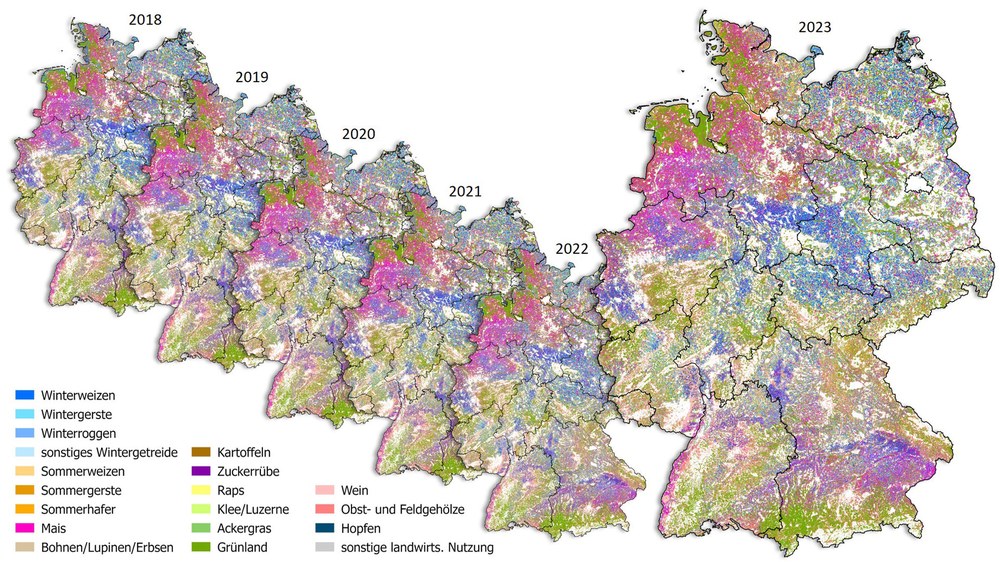
Approximately half of Germany's total land area is dedicated to agriculture. Using six years of satellite data, researchers at the German Aerospace Center (Deutsches Zentrum für Luft- und Raumfahrt; DLR) have mapped which crops are grown where and the crop rotation patterns employed. These maps have numerous applications, such as monitoring agricultural practices, assessing the impacts of climate change, identifying adaptation strategies and modelling agricultural landscapes. The researchers analysed around 76,100 satellite images, amounting to 44 terabytes of data.
"Satellite-based information on land use is reliable, comprehensive and impartial. It supports sustainable agricultural land management in Germany and provides a foundation for assessing the emerging impacts of climate change," explains Anke Kaysser-Pyzalla, Chair of the DLR Executive Board. "With the new crop maps, we can see in detail the diversity and structure of agricultural practices in our country. Earth observation consistently delivers data on cultivation areas, enabling risk assessments for crop failures caused by factors such as erosion and heavy rainfall. This information is not only valuable for science but also for regional stakeholders, authorities, associations and industry."
Analysis of 18 different crops over six years
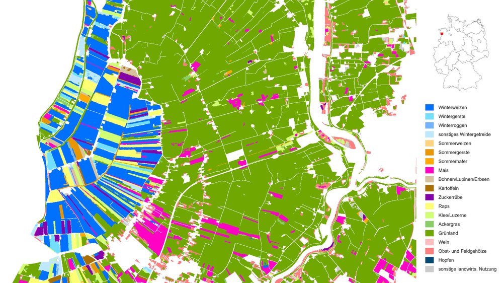
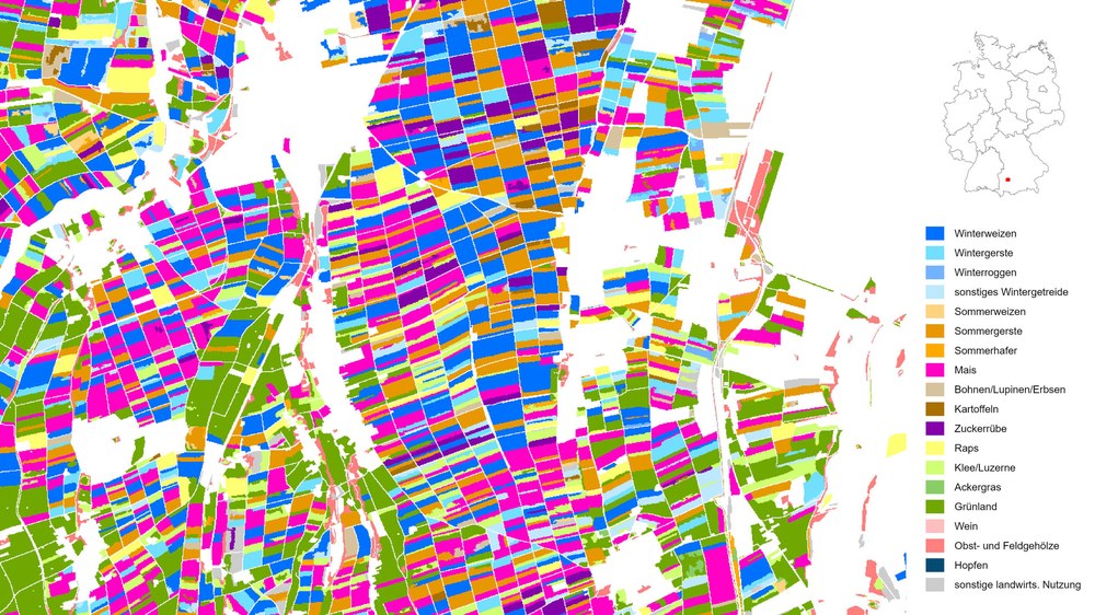
For the first time, an analysis of agricultural land use in Germany has been conducted over a six-year period, from 2018 to 2023, using satellite data with a spatial resolution of ten metres. The data is derived from time series captured by the Sentinel-1 and Sentinel-2 satellites which observe Earth's surface approximately every five days. The study includes 18 different crops and primary land-use categories: winter wheat, winter barley, winter rye, other winter cereals, spring wheat, spring barley, spring oats, maize, beans/lupins/peas, potatoes, sugar beet, oilseed rape, clover/alfalfa, grass, grassland, vineyards, fruit and field shrubs and hops. The maps reveal that wheat and maize occupy the largest cultivated areas, followed by barley.
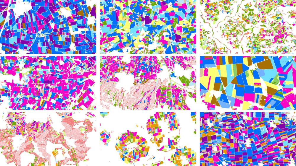
Notable regional differences in crop distribution are evident across Germany: maize is predominantly grown in the northwest and south of the Danube, while wheat is cultivated more evenly across the country's agricultural regions. A mix of wheat and sugar beet can be found in areas with nutrient-rich, mostly deep soils, such as the Magdeburg and Hildesheim Börde, parts of Franconia and in the west of North Rhine-Westphalia. Regional specialities also emerge, such as hop cultivation in the Hallertau (Holledau) region, fruit farming in the Altes Land and vineyards along the Upper Rhine, Moselle and Main rivers. These patterns are shaped by soil quality, climatic conditions, historical influences and long-standing agricultural traditions.

Analysing each field
"We can detect crops on a field-by-field basis, so for every piece of arable land, across entire regions comprehensively and uniformly for the whole of Germany. Our data sets allow us to compare arable land use over the years and derive crop rotations for individual fields. Certain crop rotations, for instance, are crucial for plant and soil health and are likely to shift as a result of climate change," explains Ursula Geßner, Head of the Agricultural and Forest Ecosystems group at the DLR Earth Observation Center (EOC). This mapping complements agricultural statistics, which typically aggregate data at the administrative level rather than focusing on individual fields. Beyond identifying the specific crops grown, the data also offers indirect insights into agricultural landscapes, water requirements, drought and pest susceptibility and agricultural diversity.
The Sentinel-1 satellites, which are part of the EU's Copernicus programme, use radar technology to observe Earth's surface regardless of lighting or cloud conditions. Sentinel-2 satellites are equipped with optical instruments that detect changes in the greenness of vegetation, for example. At the EOC, researchers combine satellite time series with machine learning techniques. The artificial intelligence (AI) systems employed achieve high accuracy, though this varies between crop classes. For example, crops such as sugar beet, rapeseed and maize are highly identifiable, whereas distinguishing between visually and developmentally similar crops, such as spring cereals or grassland, proves more challenging.
Information for authorities and research institutions
The datasets are publicly accessible through the EOC Geoservice and serve as valuable resource for authorities, institutions and research facilities. They serve as a basis of information to supplement agricultural statistics or develop strategies for adapting to climate change. Additionally, they form essential baseline data for further scientific research, including modelling the water balance, agricultural yields or calculating greenhouse gas emissions and storage in agriculture.
Related links
Research on agricultural and forest ecosystems
The Agricultural and Forest Ecosystems team at DLR's Earth Observation Center in Oberpfaffenhofen analyses extensive Earth observation time series from various agricultural and forestry regions worldwide. The team develops remote sensing-based data products and tools to support sustainable development in the context of climate change and global transformation.
The multi-year crop mapping initiative has been realised through projects such as HI-CAM and AgriSens-DEMMIN 4.0.
