German radar satellites take a sharp look at European Championship stadiums
June 12, 2024 | Earth observation mission TerraSAR-X and TanDEM-X
German radar satellites take a sharp look at European Championship stadiums
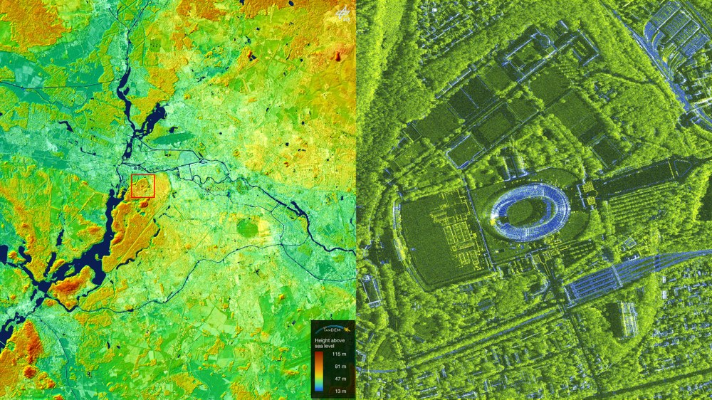
Berlin
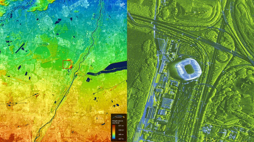
The Olympic Stadium is located at the northern end of the Grunewald forest, to the west of Berlin's city centre. The stadium was built between 1934 and 1936 for the 1936 Olympic Games. For the European Football Championships, the stadium can accommodate 71,000 spectators and therefore has the largest capacity of all the venues. In addition to the final, five other matches will be played there. The elevation model on the left shows the Spree valley from east to west, the former Tempelhof airport (green spot on the right below the centre), Wannsee lake (left half of the picture) and the adjacent Grunewald forest.
The German radar satellites TerraSAR-X and TanDEM-X have recorded all the stadiums of the 2024 European Football Championship several times at intervals of several days and weeks respectively.
TerraSAR-X and TanDEM-X are able to record 2D and 3D images with high resolution and independent of weather conditions and daylight.
Focus: Spaceflight, Earth observation, microwaves and radar systems
The 2024 European Football Championship kicks off in Germany on 14 June. The two radar satellites TerraSAR-X and TanDEM-X, operated by the German Aerospace Center (Deutsches Zentrum für Luft- und Raumfahrt; DLR), have focussed on the venues expressly for this event.
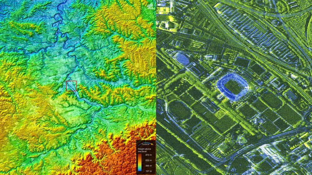
Each stadium was imaged several times at intervals of several days or weeks. The combination of the individual images produces the radar images on the right: solid, stable structures are coloured blue, while changing structures appear with a green hue. In contrast to optical satellite or aerial photos, human-made structures stand out clearly from vegetation such as trees or bushes and from open spaces in the radar images. This makes it clear what kind of environment the respective stadium is situated in.
The left-hand side presents the wider surroundings in the form of a digital elevation model. Readers with local knowledge will be able to easily identify familiar elevations or landmarks in the cities they know.
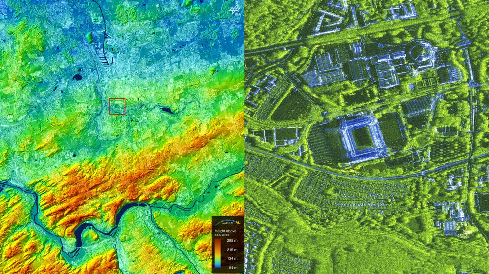
Dortmund
The 'BVB Stadium' of the football club Borussia Dortmund is located south of Dortmund city centre. The stadium was built between 1971 and 1974 for the 1974 World Cup and during the Championship will have capacity for approximately 62,000 spectators. It is used for five matches, including the semi-final.
Dortmund
The elevation model with the stadium in the centre shows Dortmund city centre on the slight elevation north of the stadium and south of the harbour. The Ardey Hills extend to the south of Dortmund. At its lower edge, the Ruhr flows from east to west with the Hengstey and Harkort reservoirs.
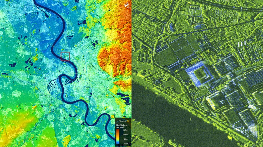
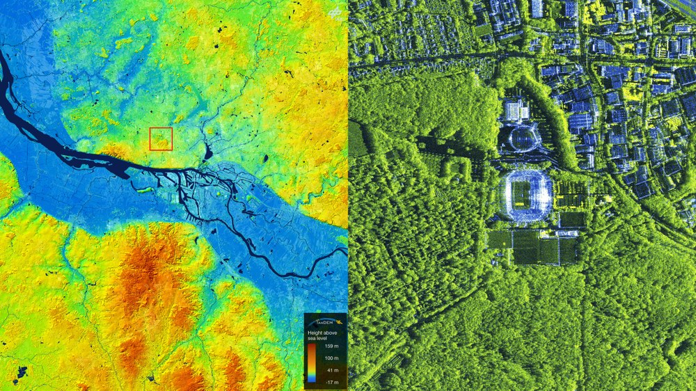
The 'Düsseldorf Arena', on the eastern bank of the Rhine and conveniently located between the city centre and the airport. During the European Championship the stadium will be able to accommodate approximately 47,000 spectators. The stadium was built between 2002 and 2004 to replace the Düsseldorf Rhine Stadium and will host five matches.
Düsseldorf
The elevation model on the left shows the Rhine valley. The foothills of the Bergisches Land can be seen to the east of Düsseldorf.
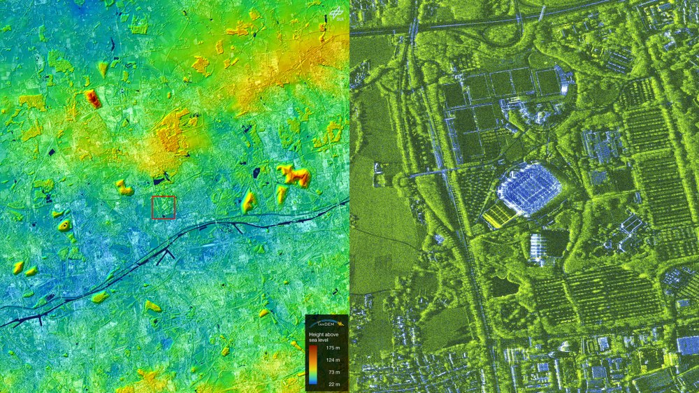
The 'Frankfurt Arena' is located in the city forest in the district of Frankfurt-Sachsenhausen, between Frankfurt Airport and the city centre. The stadium will offer space for 47,000 spectators during the matches and was built between 2002 and 2005 as the venue for the 2006 Football World Cup. The Frankfurt Arena will host five matches of the 2024 European Football Championship.
Frankfurt am Main
The elevation model on the left around Frankfurt shows the River Main, which flows from east to west and finally joins the much wider Rhine at the left edge of the picture. The mountain range to the north-west of Frankfurt is the Taunus with the Feldberg as its highest point.
The 'Arena AufSchalke' in Gelsenkirchen is located on the Berger Feld, north of the river Emscher. The arena is the venue for four games of the European Football Championship and will accommodate 50,000 spectators per match. It was built between 1998 and 2001.
Gelsenkirchen
In the elevation model on the left, the Emscher river runs through the picture from right to left. The spoil tips of the Oberscholven (top left) and Hoheward (centre right) coal mines are clearly visible as the highest elevations.
The 'Volksparkstadion' is located in the Altona Volkspark in the district of Bahrenfeld, a few kilometres north of the Elbe and west of the city centre. The stadium was built between 1951 and 1953 and has been remodelled and extended several times over the years. Five matches will be played in the Volksparkstadion, which will have capacity for 49,000 spectators, during the European Championship.
Hamburg
The elevation model clearly shows the Elbe valley, which flows from east to west, and the harbour facilities in Hamburg. To the south of the Elbe valley rises the Nordheide around Buchholz, bordered to the east and west by the Seeve and Este rivers.
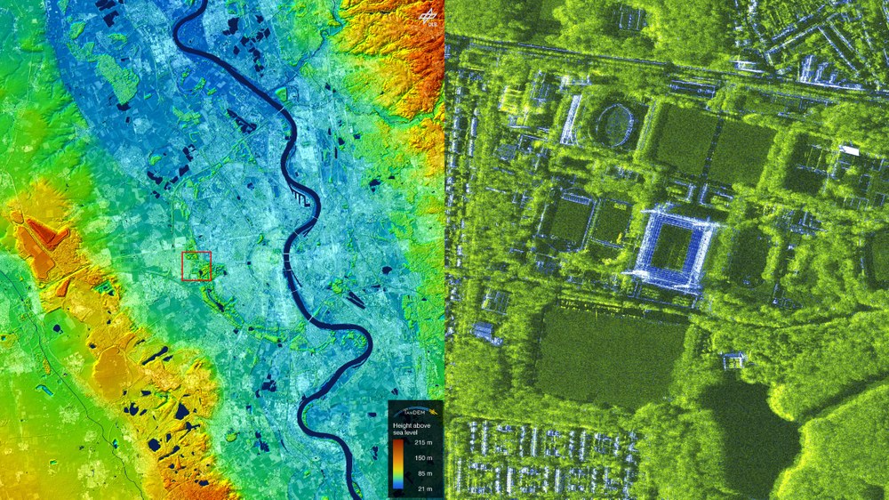
The 'Cologne Stadium' was built between 2001 and 2004 in the Cologne district of Müngersdorf, on the outskirts of Cologne on the left bank of the Rhine. For the five European Championship matches played there, the stadium will have capacity for 43,000 spectators.
Cologne
The elevation model on the left shows the Rhine valley near Cologne. The mountains on the right are the foothills of the Bergisches Land. In the centre right is the Glessener Höhe, a former spoil dump. The green belt around Cologne's old town and the city centre are also clearly visible.
The 'Leipzig Stadium' is located in the Waldstraßenviertel, a district in the north of the city centre, and is situated directly on the eastern bank of the White Elster river. During the four European Championship matches played here, the stadium will be able to accommodate 40,000 people. The stadium was built between 2000 and 2002 at the location of the former central stadium.
Leipzig
The elevation model clearly shows the traces of mining south of Leipzig, with flooded and still active open-cast mines.
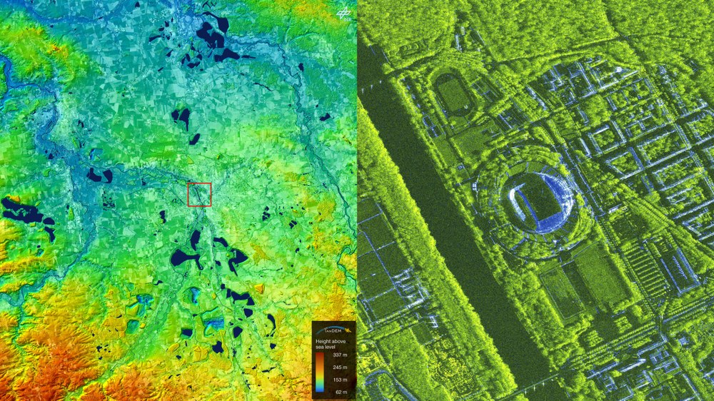
The 'Munich Football Arena' is located in the Fröttmaninger Heide in the Freimann district north of Munich. The venue was built between 2002 and 2005 and can accommodate approximately 66,000 guests. The arena will host the opening match, one semi-final and four other European Championship matches.
Munich
The elevation model shows the flat Munich gravel plain. It is bordered by the Hallertau to the north, Munich lies to the south and the Isar flows from south to north. The Nymphenburg (slightly below left) and Schleißheim (slightly above left) palace complexes, the Munich Trade Fair Centre (bottom right) and the two mounds of rubble to the north and east of the stadium are also clearly visible.
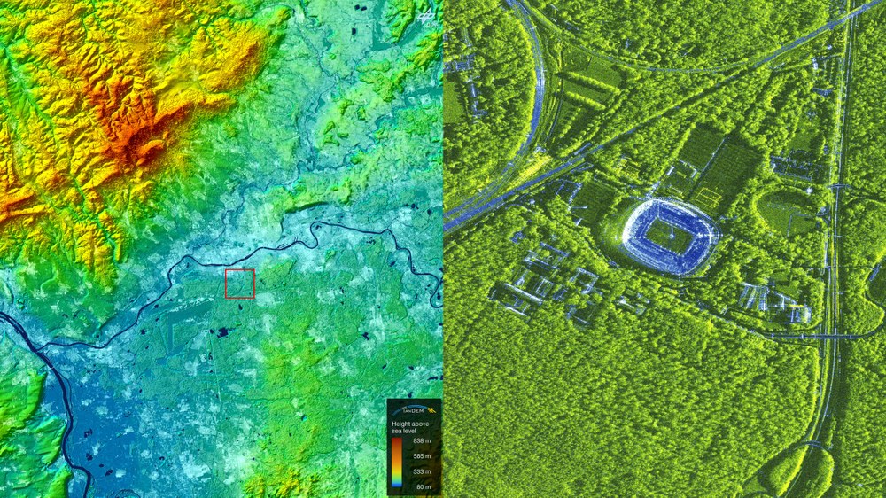
The 'Stuttgart Arena' is located in the Bad Cannstatt district on the right bank of the Neckar and to the east of the city centre. The stadium was built between 1929 and 1933 and has since been extended four times, most recently in 2011. Stuttgart will host five European Championship matches.
Stuttgart
The elevation model shows the Neckar valley, which winds its way through the picture from south to north. The foothills of the Swabian Alps can be seen at the bottom of the picture.
The TerraSAR-X and TanDEM-X missions were implemented on behalf of the German Aerospace Center (Deutsches Zentrum für Luft- und Raumfahrt; DLR), with funding from the Federal Ministry for Economic Affairs and Climate Action (Bundesministerium für Wirtschaft und Klimaschutz; BMWK).They are the first German satellites to have been created as part of a Public-Private Partnership (PPP) between DLR and Airbus Defence and Space GmbH.
DLR is responsible for the construction and operation of the ground segment as well as for the scientific use of the data and its distribution to external researchers worldwide. Airbus Defence and Space GmbH contributed to the costs of the development, construction and launch of the satellites. The Intelligence Programme Line at Airbus Defence and Space is responsible for the commercial marketing of the data. Since 2016, the project has continued under a follow-on agreement with Airbus.
TerraSAR-X and TanDEM-X are particularly suitable for observing the changes of Earth's surface. They are capable of capturing 2D and 3D images with high resolution, independent of weather conditions and time of day. Both satellites provide high-quality radar images for a wide range of applications in the scientific, commercial and security sectors.