Development of the Patagonian Ice Fields reveals the enormous complexity of physical interactions

- The Patagonian Ice Fields lost approximately nine percent less of their ice mass between 2012 and 2016 than they did between 2000 and 2012.
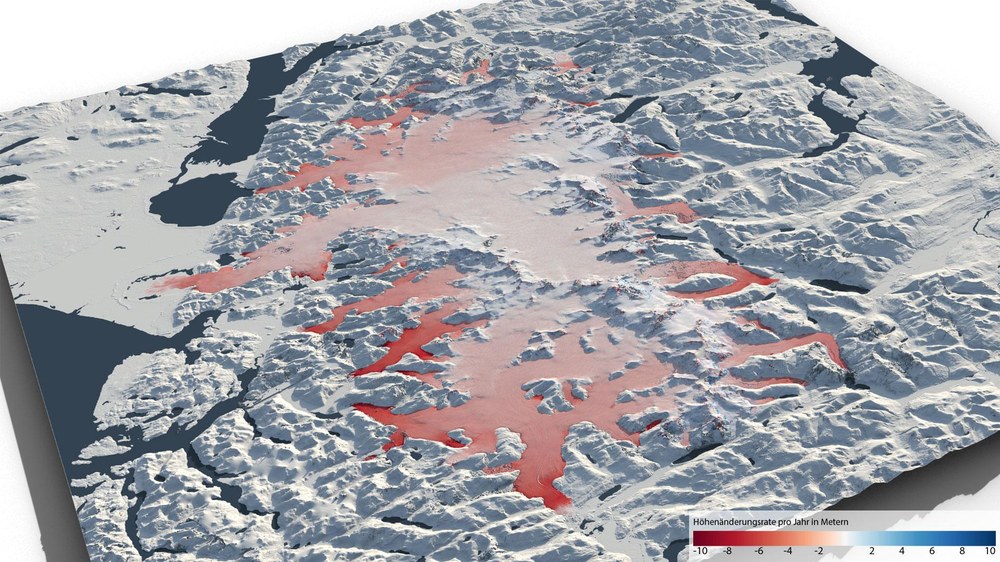
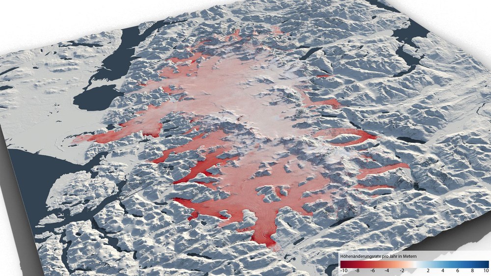
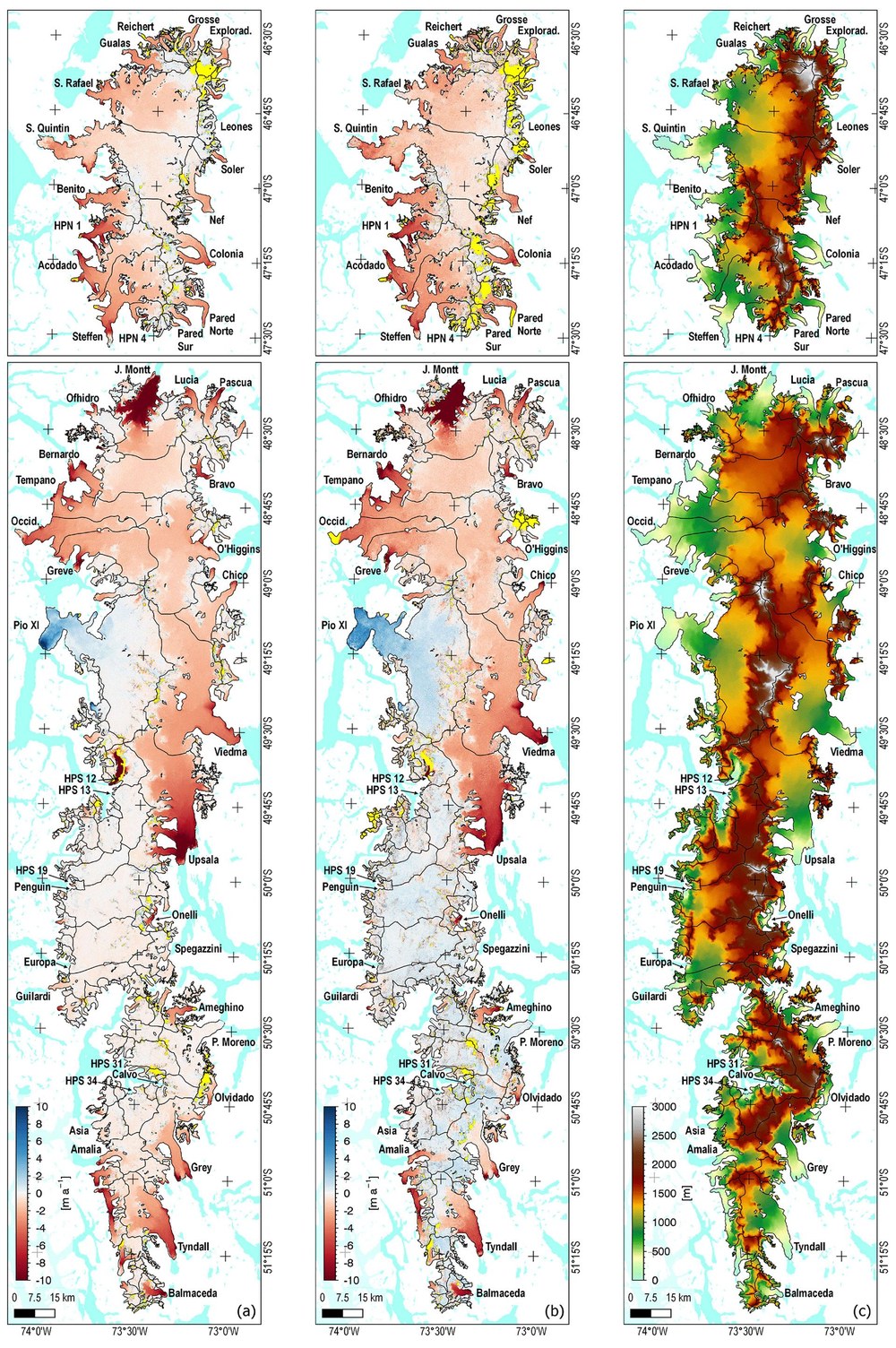
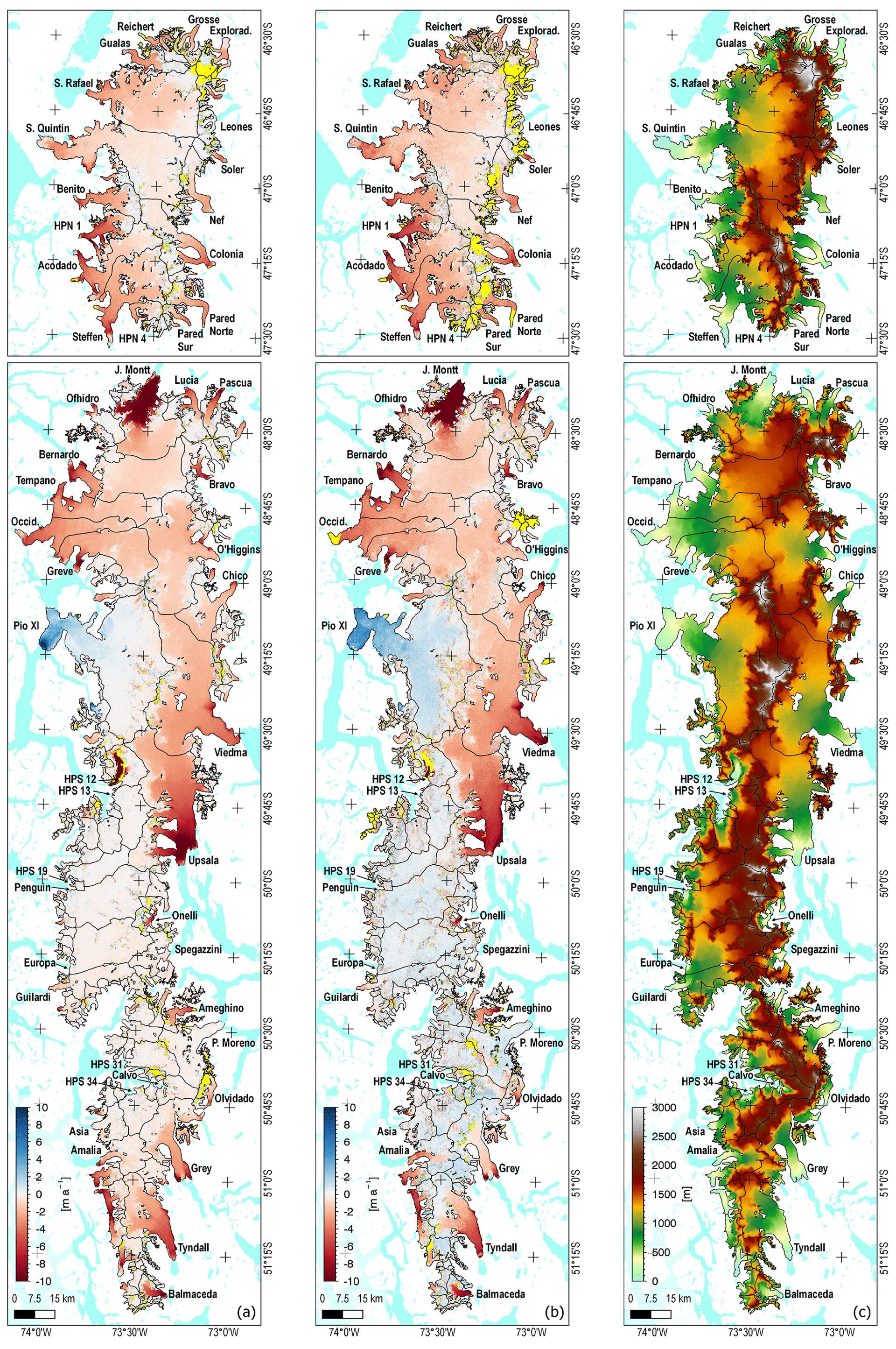
- High-precision digital elevation models derived from radar satellite data show that the changes in the northern and southern ice fields diverged in some respects.
- A study confirms the great potential of bistatic radar interferometry and the TanDEM-X mission for the accurate, detailed and almost complete mapping of ice fields.
- Focus: Space, Earth observation, global change
The glaciers and ice fields in the South American region of Patagonia have been in retreat since the Little Ice Age between the early 14th century and the mid-19th century. In recent decades, the loss of ice masses associated with tropospheric warming has accelerated. From 2000 to 2016 the Patagonian Ice Fields contributed approximately six percent to the eustatic sea level rise of 0.74 millimetres per year. This represents the average rise in sea levels due to all of the world's glaciers and ice caps – excluding the ice sheets of Greenland and Antarctica. As clear as this trend is overall, a direct comparison of the developments of the Northern and Southern Patagonian Ice Fields (abbreviated as NPI and SPI) revealed different, even contradictory trends. This demonstrates how complex the interactions between processes on the glacier surface, whicht are directly influenced by climate, and the changes in the flow velocity of the ice are.
Ice dynamics, glacier topography and climate change
These findings came directly from a study conducted by the German Aerospace Center (Deutsches Zentrum für Luft- und Raumfahrt; DLR), ENVEO IT GmbH, the Institute of Atmospheric and Cryospheric Sciences (ACINN) at the University of Innsbruck in Austria and the European Space Agency's (ESA) European Space Research Institute (ESRIN) in Italy. The team investigated the developments of the Patagonian Ice Fields NPI and SPI using radar interferometry data from two Earth observation missions – the Shuttle Radar Topography Mission (SRTM) and TerraSAR-X add-on for Digital Elevation Measurement (TanDEM-X). At the DLR Earth Observation Center (EOC), Surface Elevation Change Rate (SECR) maps of the ice fields in Patagonia were created as part of the study entitled 'Heterogeneous spatial and temporal pattern of surface elevation change and mass balance of the Patagonian ice fields between 2000 and 2016'. SECR maps are highly accurate three-dimensional views of the elevation changes of Earth's surfaces calculated over a period of several years.
The DLR researchers processed the SECR data using complex techniques and algorithms. They received precise digital elevation models corresponding to the Australian summers of 2000, 2012 and 2016. Complex processing procedures developed at the EOC enabled them to achieve coverage of more than 90 percent of the NPI and SPI with valid elevation values. The study team then analysed developments in the region over 2000-2012 (epoch one) and 2012-2016 (epoch two). When they compared the data, they found highly heterogeneous spatial patterns and conflicting temporal development between the two ice fields.
Combined, the volume losses of the Patagonian Ice Fields between 2012 and 2016 were approximately nine percent lower than between 2000 and 2012. Individually, the two ice fields behave differently. The losses of the NPI increased by 31 percent over the period of study. The opposite was the case for SPI, where the loss rate fell by 20 percent.
"A major factor in the increased mass losses on the NPI during epoch two was the fact that the air temperature was higher than in epoch one, especially during the main ablation period. This leads to increasing surface melt losses. This is the dominant process for mass reduction. The ice loss caused by calving is less important as it accounts for only approximately 20 percent of the mass loss caused by melting," explains DLR scientist Dana Floricioiu from the EOC. In the south, the spatial pattern of surface elevation changes is more complex than it is in the north, with a less uniform trend over time. In the south, flows due to calving glaciers had a greater impact on the mass balance than in the north. "Different temporal trends between the individual glaciers were due to opposite changes in flow velocities," continues Floricioiu.
The potential of bistatic InSAR for glaciers
The DLR scientists created high-resolution topographical maps from bistatic Interferometric Synthetic Aperture Radar (InSAR) data acquired by NASA's SRTM in 2000 and the follow-up TanDEM-X mission. Until now, these missions are the only ones to have been equipped with single-pass radar interferometers. The study team derived surface elevation changes for both the NPI and the SPI during epoch one and epoch two.
"The study confirms the potential of bistatic InSAR and the TanDEM-X mission in particular for the precise, detailed and almost complete mapping of surface elevation changes for both large ice fields and smaller ice basins and glacial tongues," sums up Floricioiu. The scientist emphasises that: "We hope that our results will promote the development of new remote sensing missions that are capable of repeated bistatic InSAR observations and pave the way for regular worldwide SECR mapping and mass balance estimates with improved temporal sampling."
The TanDEM-X mission
The DLR German Remote Sensing Data Center (DFD) at the Earth Observation Center (EOC), the DLR Microwaves and Radar Institute and the DLR Remote Sensing Technology Institute (IMF) are all involved in the mission. Together, they make up the SAR Center of Excellence. The institutes complement one another by addressing all of the relevant areas – from sensor technology and mission design to high-precision processing of the raw data, all the way through to the creation of products for the end users. Together with the DLR German Space Operations Center (GSOC), they are also responsible for the development and operation of the ground segment – the infrastructure for operating the satellites – and for data processing. The DLR Microwaves and Radar Institute in Oberpfaffenhofen is responsible for the scientific management of the mission.
Follow-up Tandem-L mission
A possible follow-up mission to TanDEM-X has already been designed by DLR. The Tandem-L mission concept envisages two radar satellites operating in the L-band (23.6-centimetre wavelength) to record global processes such as the dynamics of the Patagonian ice fields globally and systematically. The aim of Tandem-L is to interferometrically map the entire Earth's land mass on a weekly basis. The mission will set new standards in Earth observation, observe global change with a new quality and allow important recommendations for action to be made. The new technology will enable the recording of the three-dimensional structures of vegetation and ice areas as well as the large-scale measurement of deformations with millimetre accuracy.