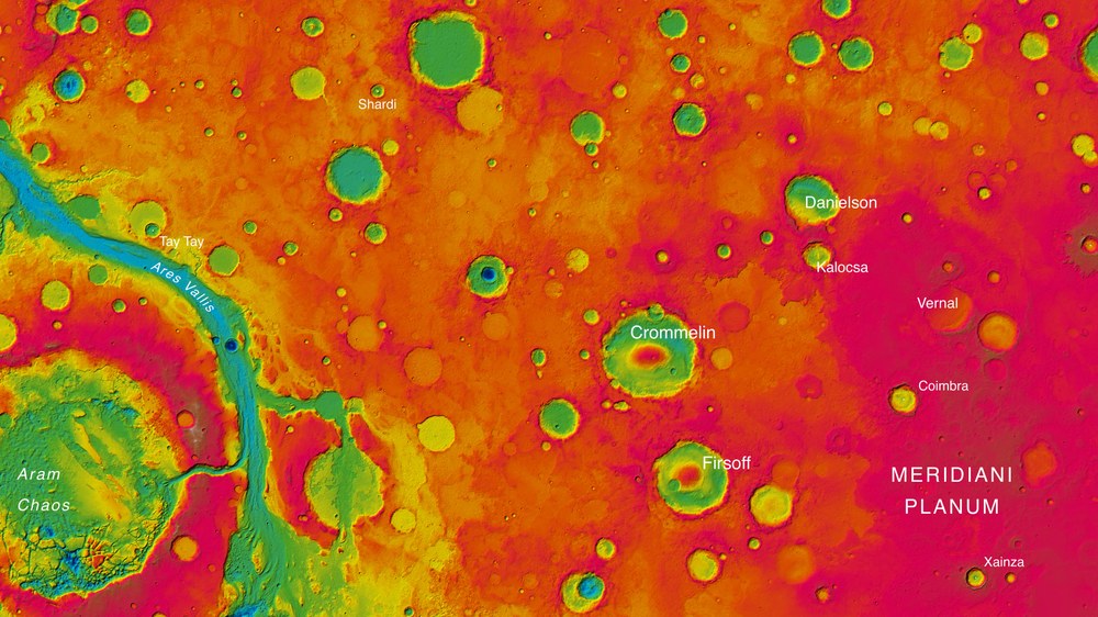
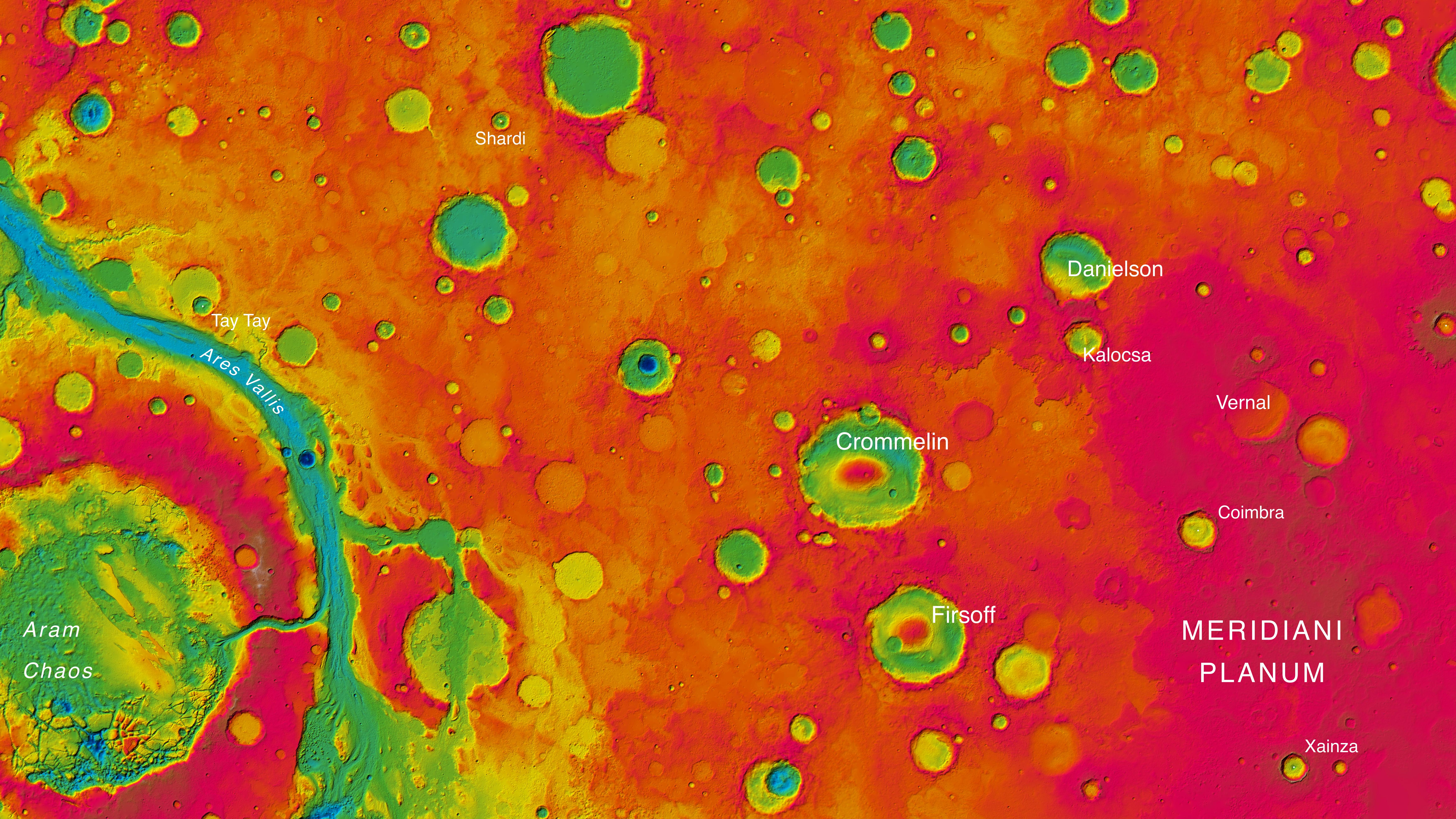
The High Resolution Stereo Camera (HRSC) operated by DLR on board ESA’s Mars Express spacecraft has been imaging parts of the planet’s surface every third of fourth orbit since January 2004. In the course of 11 years, it has created over 4000 image strips, each between 50 and 100 kilometres wide and several hundred kilometres long from north to south. The stereo images, acquired with nine sensors, show not just the Martian surface in colour, but also allow the elevation to be computed for each pixel. The Working Group for 3D Mapping in the HRSC team has now performed these calculations for the eastern half of the map sheet ‘MC-11’ near the Martian equator. This image mosaic covers 2.3 million square kilometres, an area about six times the size of Germany. The figure shows a detail of the colour-coded relief map with high altitude areas in red and orange and low-lying areas in yellows, greens and blues. The range of differences in height is about 5000 metres.
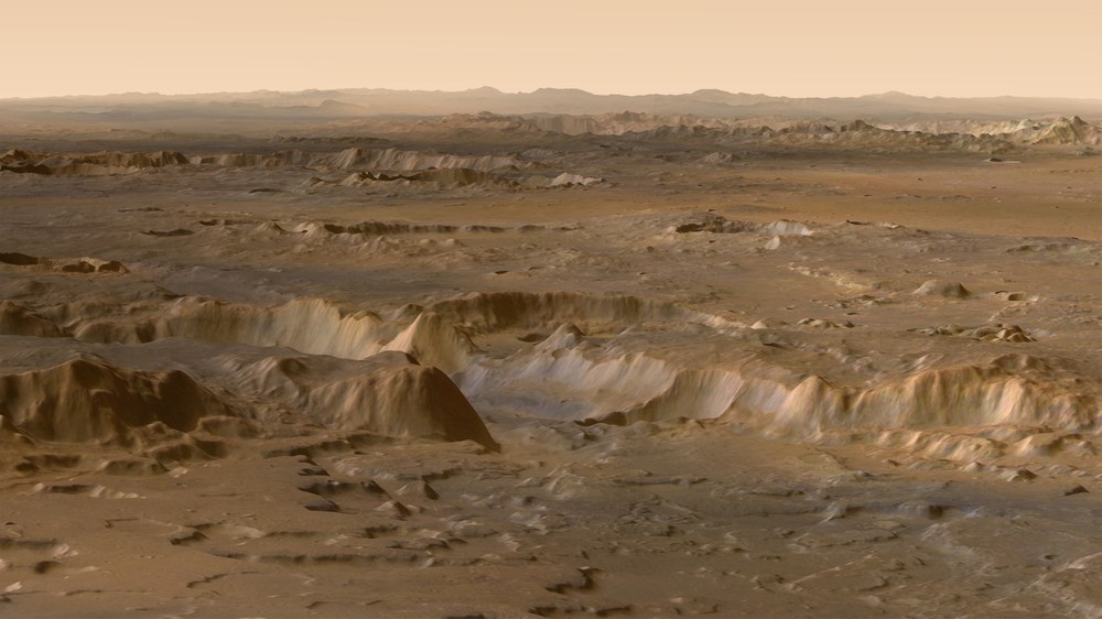
Mars in 3D – view over Meridiani Planum looking north
The most important feature of the image data acquired by the High Resolution Stereo Camera (HRSC) operated by DLR on board ESA’s Mars Express spacecraft is the possibility of deriving digital terrain models. These can be related to a reference level and realistic perspective views of the Martian surface generated for each pixel elevation level. This scene shows a view from just north of the equator on the highland plain Meridiani Planum, over the 2000-metre-deep branches of Ares Vallis towards the mountain ranges in the transition zone leading to the northern lowlands of Mars. In the middle distance, some impact craters with diameters of several tens of kilometres are visible. The vertical scale is exaggerated by a factor of three.
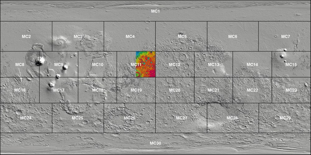
Mars’s diameter is about half of Earth’s; thus, it has a much smaller overall surface area. However, since it has no oceans, its landmass of 145 million square kilometres is roughly the size of the area of all continents of the Earth combined (149 million square kilometres). As on Earth, the mapping of Mars follows a firmly established geometric scheme, such as in the form of 30 longitudinally arranged map sheets specified by the US Geological Survey ‘Mars Chart’ (MC). The scenes presented here come from the eastern half of map sheet MC-11 ‘Oxia Palus’ in the central highlands of Mars. The aim of the HRSC experiment on Mars Express is to derive digital terrain models for the thousands of image strips in resolutions between 10 and 50 metres per pixel for every one of the 30 MC map sheets image mosaics.
Previously, images of Mars were available in strip format – strip by strip carefully flown with the European Mars Express spacecraft and processed into three-dimensional terrain models and perspective images. Now, planetary scientists, under the leadership of the German Aerospace Center (Deutsches Zentrum für Luft- und Raumfahrt; DLR) have, for the first time, joined these individual 50 to 100 kilometre wide strips to create a single large-scale map. The first mosaic comprises 2.3 million square kilometres of the surface, and covers the vast crater-strewn highland region of the Red Planet, parts of the Ares Vallis outflow channel, the chaotic Aram Chaos region as well as the Meridiani Planum and Chryse Planitia plains. "Gerhard Mercator and Carl Friedrich Gauss measured Earth, and with our survey of Mars we are following in their footsteps," says Ralf Jaumann, a DLR planetary scientist and Principal Investigator of the High Resolution Stereo Camera (HRSC) on board the Mars Express spacecraft. "The quality we have attained with the HRSC images had never before been achieved."
Borderless and uniform
The mosaic extends over 1800 kilometres from north to south and 1300 kilometres from east to west. Individual stereo and colour images from a total of 89 Martian orbits were combined to create this product. "The strips were recorded at varying resolutions, with the Sun at different positions and under varying weather conditions. The challenge was to combine them uniformly and without visible borders to form one large image," Jaumann explains. For this, the geometric relationships of the individual images to one another and their geographical position must be determined with high precision. In doing so, it is possible to measure Mars accurately and globally.
The data for this wide-area topography of Mars was acquired with the HRSC, which has been orbiting the Red Planet together with Mars Express since 25 December 2003. Nine sensors record the surface of the planet from different angles and make it possible to map our planetary neighbour at high resolution, in colour, and in the third dimension – elevation. HRSC has, during the course of more than 14,000 orbits, recorded and transmitted a total of 293.34 gigabytes of data to Earth. Coverage of 70 percent of the Martian surface with image resolutions of 10 to 20 metres is being used for the highest precision 3D mapping. Additional datasets will continue to be recorded and analysed. About 97 percent of the planet has been recorded with image resolutions of up to 100 metres.
Video about the cartography of the surface of Mars
The Cartography of the Surface of Mars
Your consent to the storage of data ('cookies') is required for the playback of this video on Youtube.com. You can view and change your current data storage settings at any time under privacy.
The Cartography of the Surface of Mars
Video about the cartography of the surface of Mars
Credit:
DLR
The next step is the successful processing of large-scale mosaics achieved by a working group led by DLR planetary researcher Klaus Gwinner: "Surveying the planet marks another milestone," says Gwinner. By around 2018, the team from DLR, FU Berlin and Hannover University wants to represent the whole of Mars as one coherent mosaic.
3D view of valleys and craters
The first completed mosaic is the basis for a variety of uses. Colour-coded digital terrain models show the impressive differences in height between the Meridiani Planum region at 250 metres below the nominal level of the Martian surface up to the 5000 metres lower-lying Chryse Planitia region. Perspective views look into the Ares Vallis outflow channel or into a crater altered by typical Mars erosion processes typical on Mars. "At present, you cannot create a better image of the surface of Mars to show, for example, of the effects of flood and drought," emphasises Jaumann. Landing missions also benefit from the detailed 3D maps of Mars; for the Mars rover Curiosity, DLR planetary researchers participated in several workshops and used the regional 3D products from HRSC to assist in the selection of the appropriate landing site. In the future, when the landers from the NASA InSight mission or the ESA ExoMars mission land on the Red Planet, the engineers will also be able to produce an extremely accurate image of the landing site in three dimensions – with data from HRSC.
The HRSC experiment
HRSC was developed at DLR and built in collaboration with partners in industry (EADS Astrium, Lewicki Microelectronic GmbH and Jena-Optronik GmbH). The science team, which is headed by Principal Investigator (PI) Ralf Jaumann, consists of 52 co-investigators from 34 institutions in 11 countries. The camera is operated by the DLR Institute of Planetary Research in Berlin-Adlershof.