This Valentine's Day, DLR presents a selection of fitting images captured by the German radar satellites TerraSAR-X and TanDEM-X.
Heart-shaped structures can be found in the Dasht-e Lūt desert, along the course of the Juruá River in Brazil and near the Australian town of Koné, among other places.
The two German radar satellites that made these observations are perfectly placed to take such high-resolution 2D and 3D images, regardless of weather conditions or time of day.
Focus: Space, Earth observation
14 February is Valentine's Day, known in Spain and Portugal as the 'Day of Lovers' or in Scandinavia, the 'Day of All Hearts'. To mark the occasion, the German Aerospace Center (Deutsche Zentrum für Luft- und Raumfahrt; DLR) is showcasing a selection of fitting images from the German radar satellites TerraSAR-X and TanDEM-X. These images illustrate the wide-ranging capabilities of the satellites – from high-resolution, single-polarised images brimming with detail, to dual-polarised images that reveal ground moisture, to digital elevation models that capture Earth’s structure in all its beauty.
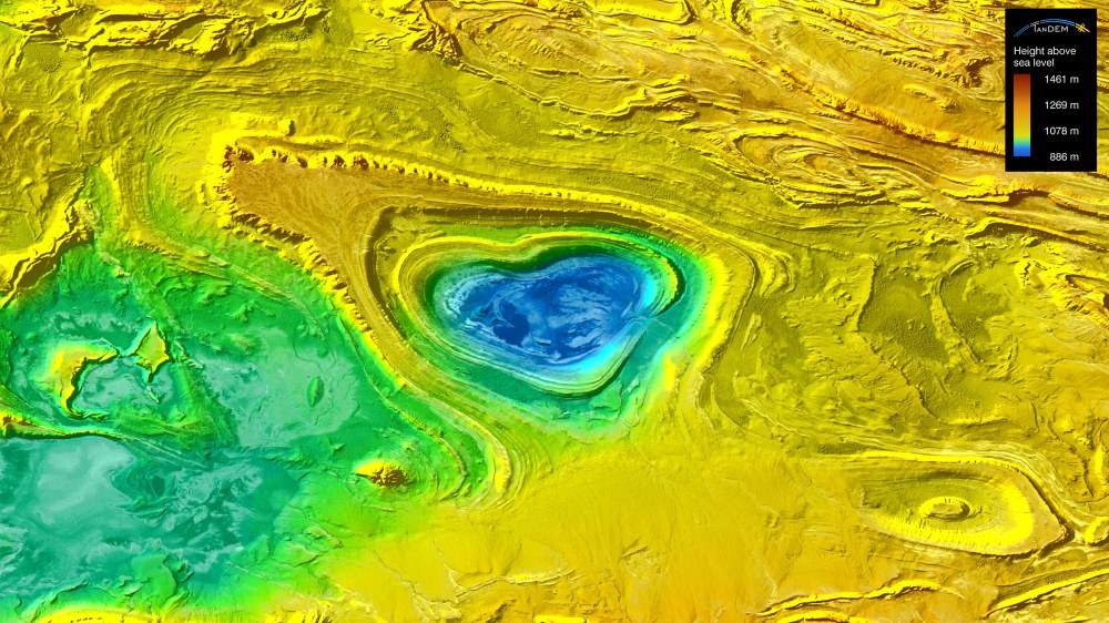
Dasht-e Lūt
The first heart-shaped formation above is located in the northern part of the Dasht-e Lūt desert in Iran, approximately 75 kilometres northwest of Behabad. The heart itself spans an impressive width of about 12 kilometres. TerraSAR-X and TanDEM-X worked together to generate the digital elevation model.
Using radar interferometry, DLR researchers derived elevation data from the radar signals. The elevation model was then rotated clockwise by roughly 120 degrees. The heart was first colour-coded based on its height information, after which elevation fluctuation data was transparently superimposed. This process brought out fine details, including intricate structures with the salt lake located 'in the heart of the heart'.
Céu Aberto
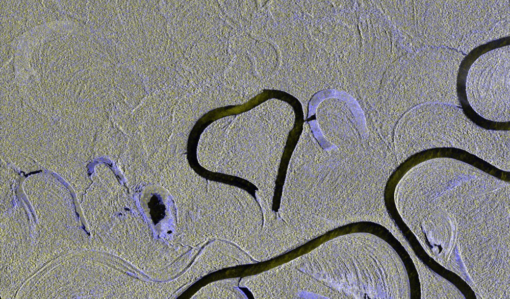
Heart-shaped branch of the Juruá river in Brazil
From this point, the Juruá flows for another 500 kilometres before merging with the Amazon River. The heart has a width of approximately 4.2 kilometres.
The second image shows a branch of the Juruá River in Brazil, near the village of Céu Aberto. From this point, the Juruá flows another 500 kilometres before merging with the Amazon River. The heart has a width of approximately 4.2 kilometres, and was captured using a dual-polarised image.
Here, the satellite alternates between transmitting and receiving radar waves with vertical and horizontal polarisation. Since the TerraSAR-X and TanDEM-X satellites 'look' downwards at an angle, the river appears black. Light blue areas indicate varying levels of reflection for the two polarisations, possibly due to moisture in the ground. Grey areas represent dense forest cover within the tropical rainforest.
Koné
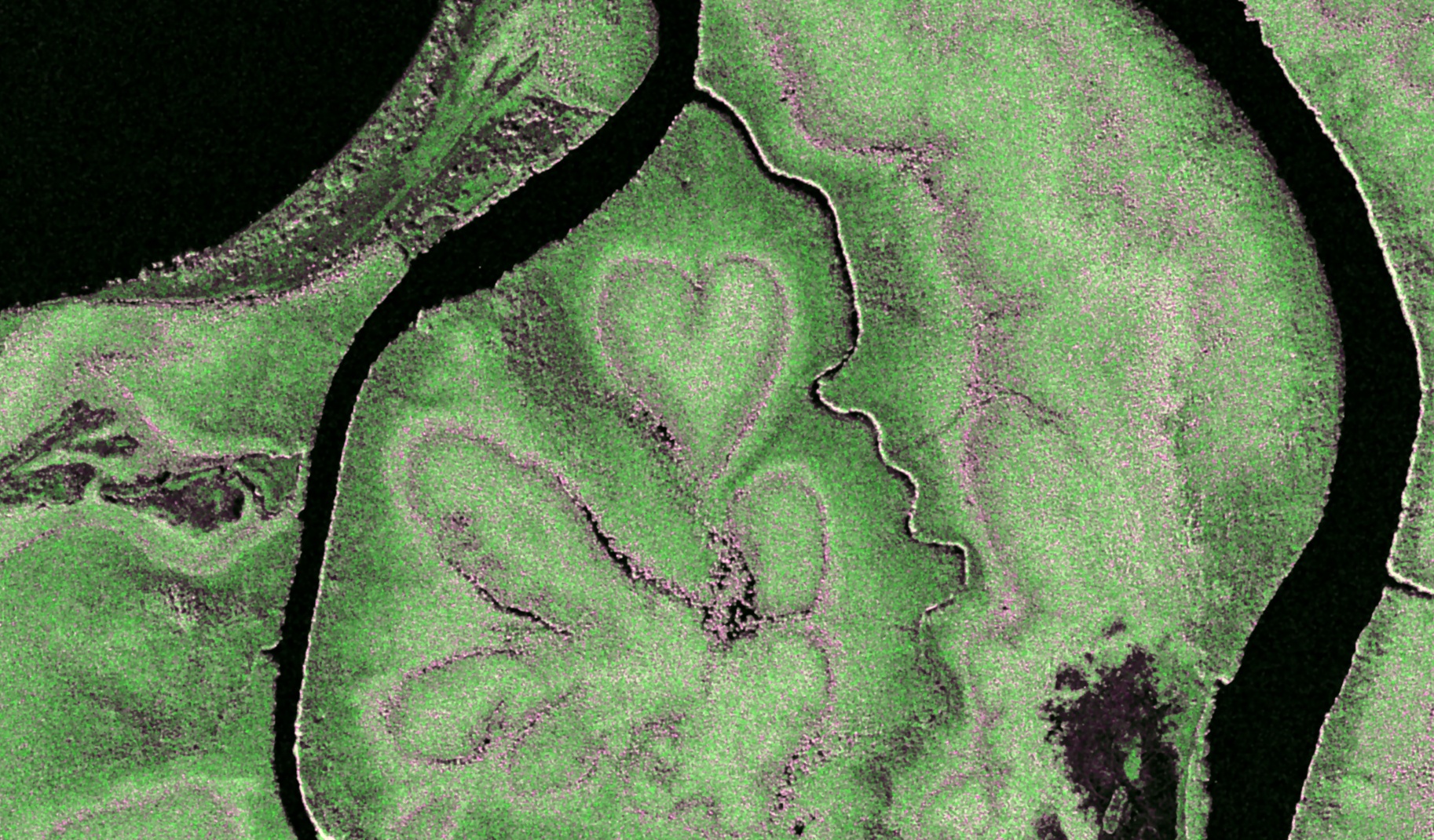
The 'Heart of Voh' in New Caledonia
This island is located approximately 1500 kilometres east of Australia in the Pacific Ocean. The heart-shaped natural phenomenon near the town of Koné is approximately 230 metres wide.
Another SAR image features the famous 'Coeur de Voh' ('Heart of Voh') near the town of Koné on the island of New Caledonia, which lies approximately 1500 kilometres east of Australia in the Pacific Ocean. This natural phenomenon, measuring approximately 230 metres across, was formed by chance when salt deposits cleared a patch in the mangrove forest along the west coast.
The Staring Spotlight image was colour-enhanced based on local backscatter intensity. As a result, forested areas appear in dark green, regions with lower vegetation in lighter green, and transition zones are depicted in pink.
About the mission
The TerraSAR-X and TanDEM-X missions were develop by the German Aerospace Center (Deutsches Zentrum für Luft- und Raumfahrt; DLR) with funding from the Federal Ministry of Economic Affairs and Climate Action (Bundesministerium für Wirtschaft und Klimaschutz; BMWK). These missions represent the first German satellites to have been created as part of a Public-Private Partnership (PPP) between DLR and Airbus Defence and Space GmbH.
DLR is responsible for the construction and operation of the ground segment, as well as facilitating the scientific use of the data and its distribution to external researchers worldwide. Airbus Defence and Space contributed to the costs of the development, construction and launch of the satellites. The Intelligence Programme Line at Airbus Defence and Space is responsible for the commercial distribution of the data. Since 2016, the project has continued under a follow-on agreement with Airbus.
TerraSAR-X and TanDEM-X are exceptionally well-suited for observing changes on Earth's surface. They can capture high-resolution 2D and 3D images, regardless of weather conditions and time of day. Both satellites deliver high-quality radar images for a wide range of applications in the scientific, commercial and security sectors.

