HALO under EarthCARE in tandem flight – measurement flights from aircraft and satellite
September 4, 2024 | Research flights to maximise data quality of the EarthCARE Earth observation mission
HALO under EarthCARE in tandem flight – measurement flights from aircraft and satellite
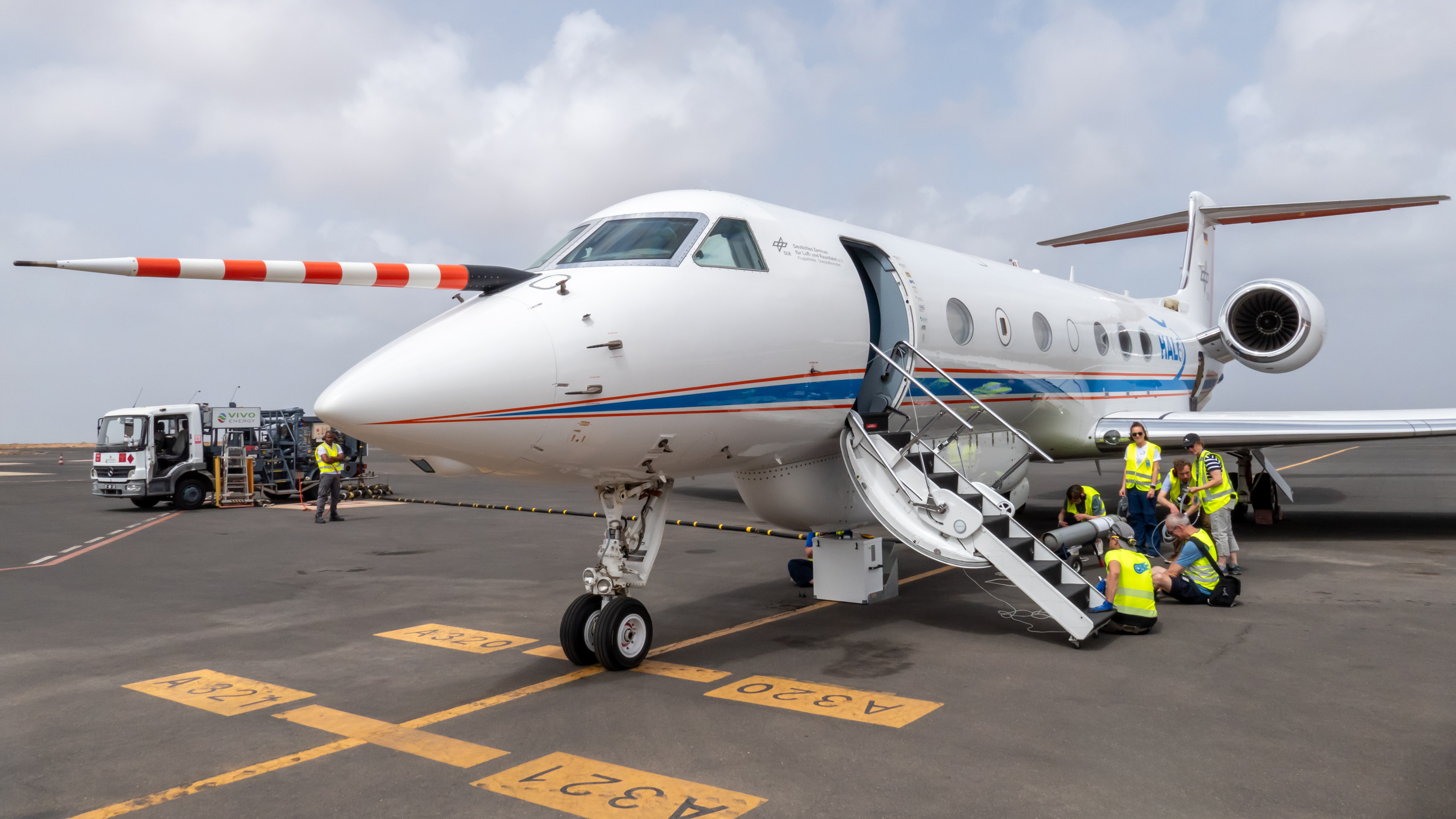
Preparing the instruments
For each validation flight, the scientists check HALO's measuring instruments. This photo shows the team preparing the radiometer and flushing it with nitrogen. Several instruments are installed in the lower fuselage compartment, where they are precisely calibrated again before take-off.
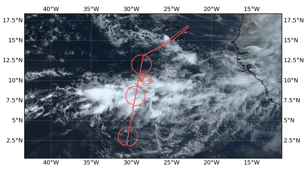
For the comparative measurements, the DLR research aircraft HALO flies exactly below the EarthCARE satellite. The line running vertically downwards corresponds to the path of HALO and the satellite, which only takes a few minutes to complete its overflight. HALO then measures the clouds along the satellite track in targeted circles. The image shows the course of a flight path during a nine-hour HALO measurement mission over Cabo Verde on 13 August 2024.
Over Cabo Verde, strong influences of Saharan dust are often visible. The upper half of the image shows the sunset light, but the reddish colour of the air layer below is due to Saharan dust. The dust layer is so cloudy and extensive that it completely covers the horizon, as seen here from HALO.
Image: 3/3, Credit:
B. Stevens
The HALO research aircraft from DLR has successfully completed its most demanding mission to date in terms of flying and science, conducting measurement flights over Cabo Verde to validate the EarthCARE satellite mission.
HALO's flights are conducted directly beneath the EarthCARE satellite to calibrate its instruments and enhance the accuracy of Earth observation data.
The collected data will contribute to a deeper understanding and improved prediction of climate patterns and weather dynamics. Following Cabo Verde, validation flights will continue in Barbados, and from November, in Germany, Europe and the Arctic region.
Focus: Aviation, Earth observation, climate
The HALO research aircraft from the German Aerospace Center (Deutsches Zentrum für Luft- und Raumfahrt; DLR) has successfully completed the first phase of its most challenging mission to date, in terms of flying and science, over Cabo Verde. Since the beginning of August 2024, HALO (the High Altitude and Long Range research aircraft) has been flying close to the equator, measuring how tropical air masses and cloud systems behave at different altitudes, all in sync with the EarthCARE (Earth Cloud Aerosol and Radiation Explorer) Earth observation satellite. HALO flies precisely beneath the satellite, ensuring that the measurements from both the aircraft and satellite are directly comparable. The instruments on board the research aircraft use the same principles of measurement as the satellite. HALO's data helps to calibrate the instruments on board the satellite, optimising the data evaluation of the EarthCARE mission. The flight team has successfully completed ten 'underflights' since the start of the mission by bringing HALO directly in line with EarthCARE. The first measurement data from the aircraft and satellite are already being analysed.
Improving forecasts for climate and weather patterns
Data collected by HALO will provide insights into cloud formation, the influence of aerosols and solar radiation, their interactions and their impact on Earth's energy balance. The European-Japanese EarthCARE satellite was launched three months ago and will help to better understand and predict climate events and weather dynamics in the coming years.
HALO is now contributing to the commissioning of the satellite and will ensure EarthCARE provides data for researchers of the best possible quality right from the start. The validation mission is being led by the DLR Institute of Atmospheric Physics in Oberpfaffenhofen under the scientific leadership of the Max Planck Institute for Meteorology in Hamburg and is being carried out in collaboration with other national and international research institutions.
Cloud formation
For the EarthCARE validation flights, HALO is equipped with a total of nine instruments and additional drop probes. The data from the HALO Microwave Package (HAMP) shows a vertical section through clouds, with individual measurement data from the cloud radar and the associated radiometer. The top line shows the cloud band in the Intertropical Convergence Zone. The red vertical line marks the exact time at which the DLR research aircraft flew under the EarthCARE satellite. The airborne data helps to calibrate the instruments on board the satellite and to optimise the data evaluation of the EarthCARE mission.
To validate EarthCARE, the DLR research aircraft will need to operate in a wide variety of atmospheric conditions. These include dry and humid climate zones, different atmospheric layers from high to low altitudes, and both clean air masses and those containing aerosol particles. The Cabo Verde islands, for example, present highly complex conditions, with several influential factors coming together in the atmosphere to produce a near-chaotic measurement field. "In addition to island effects, some atmospheric layers are heavily interspersed with Saharan dust. Added to this are factors such as the 'African easterly jet', a seasonal strong wind that significantly influences the development of tropical cyclones over the Atlantic. Due to its proximity to the equator, there is also intense solar radiation in this region, which is another key focus for EarthCARE," explains DLR project manager Silke Groß from the DLR Institute of Atmospheric Physics.
After four weeks on the Cabo Verdean island of Sal, the next stop for HALO will be Barbados from 5 to 30 September. On the way there, further west, the DLR crew can expect an almost dust-free atmosphere. Essentially, laboratory conditions will prevail – an ideal scenario for researchers to compare their results with EarthCARE's measurement data. To carry out this mission, HALO is equipped with a total of nine instruments, notably a Doppler radar and a high-resolution spectral lidar. During all measurement flights, meteorological 'drop probes' deployed from HALO obtain wind, humidity and temperature data from the whole atmospheric column below the aircraft.
Measurement flight over Sal, Cabo Verde
Low stratus clouds over the region of the Cabo Verdean island of Sal. These stratus clouds form below an altitude of approximately two kilometres and do not continue to grow upwards. The image was taken on board the DLR research aircraft HALO during a measurement flight to validate the EarthCARE observation satellite.
HALO is ideally suited for extremely demanding flights like these. The former business jet has been meticulously equipped with instruments tailored to EarthCARE's needs, enabling it to fly at altitudes up to 15.5 kilometres with a range exceeding 8000 kilometres. Together with the EarthCARE satellite, HALO measures critical phenomena such as the 'Intertropical Convergence Zone' right through to its transition zones. This several-hundred-kilometre-long band of clouds forms near the equator and influences, among other things, the rainy season in the tropics and subtropics, the monsoon region over Asia and Africa and the boundaries of the climate zones.
Flying under the satellite's flight path at exactly the right time is a challenge on every journey. HALO's pilots must react with flexibility to last-minute changes to the flight plan, while the DLR Flight Experiments team also contributes its expertise to flight planning: based on the satellite's position, they calculate the optimal trajectory for the aircraft, which is then reviewed by air traffic control and typically fine-tuned during flight operations.
Reference data from the ground, at sea and in the air
The validation of EarthCARE is HALO's most challenging and extensive mission to date. A total of 296 flight hours are planned through the end of the year, with up to three missions per week. The DLR team will also include additional measurements for the satellite validation. During the four-week campaign in Cabo Verde, for example, additional ground measurements were carried out by the Leibniz Institute for Tropospheric Research, ship measurements from the Max Planck Institute for Meteorology as well as measurement data from the French turbo-prop aircraft SAFIRE ATR-42 and the Norwegian-Romanian team with the turboprop INCAS KingAir. In the coming weeks, the Barbados Cloud Observatory will supplement HALO's measurements.
At the end of September, the DLR research aircraft will then return to Oberpfaffenhofen, Germany, to test EarthCARE in new atmospheric conditions at temperate latitudes, starting in November. Flights over Germany and Europe as far as the Arctic regions will further extend HALO's measurement profile, enabling DLR to ensure the EarthCARE mission can truly maximise its data potential.
The validation flights for the EarthCARE satellite mission are led by the DLR Institute of Atmospheric Physics together with the Max Planck Institute for Meteorology (MPI-M). The PERCUSION (Persistent EarthCare underflight studies of the ITCZ and organized convection) validation mission is part of the overall ORCESTRA (Organized Convection and EarthCare Studies over the Tropical Atlantic) campaign, which is scientifically led by the MPI-M. The Ludwig-Maximilians-Universität München (LMU) and the Universities of Cologne, Leipzig and Hamburg are also involved in the flight campaign with funding from the German Research Foundation. The flights are coordinated with validation activities from the German Research Foundation (DFG), among others the Leibniz Institute for Tropospheric Research (TROPOS), the Forschungszentrum Jülich research centre and the Deutscher Wetterdienst national weather service. The HALO research aircraft is operated by the DLR Flight Experiments facility in Oberpfaffenhofen.
The evaluation of airborne data from the ORCESTRA campaign for the purpose of EarthCARE validation is funded by the European Space Agency (ESA). Although an ESA mission, EarthCARE was developed as a cooperation between ESA and the Japan Aerospace Exploration Agency, JAXA, which provides the cloud profiling radar instrument. The German Space Agency at DLR is also heavily involved in the EarthCARE mission as part of the European Space Agency's FutureEO Earth observation programme, in which Germany is the programme leader and has contributed several hundred million euros to date.
About HALO
The HALO (High Altitude and Long Range) research aircraft is a joint initiative of German environmental and climate research organisations. HALO is funded by grants from the Federal Ministry of Education and Research (BMBF), the German Research Foundation (DFG), the Helmholtz Association, the Max Planck Society (MPG), the Leibniz Association, the Free State of Bavaria, the Karlsruhe Institute of Technology (KIT), the Jülich Research Centre (FZJ) and DLR. DLR is both the owner and operator of the aircraft.
Contact
Bernadette Jung
German Aerospace Center (DLR)
Communications and Media Relations: Oberpfaffenhofen, Augsburg, Weilheim


