Dive into the 2024 Olympic Games

- The 2024 Olympic Games, officially the Games of the XXXIII Olympiad, will take place in Paris from 26 July to 11 August 2024.
- DLR presents the venues from space with the help of various radar satellite images.
- A virtual flight starts with an overview of France in the form of a digital terrain model captured by TanDEM-X.
- Experts have combined detailed images of Versailles and the centre of Paris from several images.
- Focus: Spaceflight, radar satellites, TerraSAR-X, TanDEM-X
From 26 July to 11 August 2024, Paris will host the world's top athletes at the 2024 Olympic Games, officially the Games of the XXXIII Olympiad. The Games will be held across 62 different venues in Paris and the surrounding areas and eight other cities in France.
The German Aerospace Center (Deutsches Zentrum für Luft- und Raumfahrt; DLR) is showcasing these venues from space using various satellite images, enabling you to dive into the heart of the French metropolis on a virtual flight. The two radar satellites TerraSAR-X and TanDEM-X have provided detailed views of the French capital.
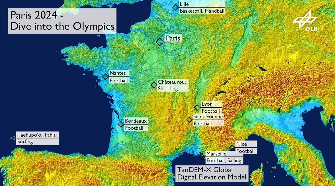
Digital terrain model of France
The virtual flight begins with a view of the entirety of France in the form of a digital terrain model, captured by the TanDEM-X satellite mission. The western part of the Alps and the Pyrenees on the Spanish border are clearly visible. The valleys of the Seine (top centre, towards the English Channel), the Loire (centre left, towards the Atlantic) and the Rhône (bottom centre, towards the Mediterranean) carve deep trenches into the landscape.
In this large-scale 'WideScanSAR' image, the French capital stands out as a white cloud amidst the predominantly agricultural landscape. However, the 220-kilometre-wide image strip only allows for a pixel resolution of around 40 metres. To identify finer objects around the various venues, the DLR team created high-resolution images in 'Staring Spotlight Mode' with a resolution of less than one metre.

Video: Paris 2024 – Dive into the Olympics
Your consent to the storage of data ('cookies') is required for the playback of this video on Quickchannel.com. You can view and change your current data storage settings at any time under privacy.
Paris and Versailles in Staring-Spotlight Mode
Experts combined detailed images of Versailles and the centre of Paris from several sources and coloured them using what is known as 'coherence' – a method that detects the smallest changes in objects and structures over time. Areas that change more frequently, such as forests, trees or meadows, appear in green. Stable, mostly human-built structures are shown in blue.
The Eiffel Tower, tilted sideways, catches the eye. This effect is created by the radar satellites flying over the scene from south to north and observing Earth at an angle to the bottom right (rather than directly from above). The position of objects on the ground is determined in the image via the time of flight or distance travelled by the radar signals. At a viewing angle of around 45 degrees, the travel times from the tower, such as from its tip to the satellites, and the pixels of the Seine are similar. As a result, the Eiffel Tower 'tilts' to one side and the top of the tower appears in the Seine.
Some venues were built specially and only temporarily for the Olympics. This can be clearly seen with the radar satellites by comparing two images – before the spectator stands were erected (2019) and after (2024). In the images shown here, the changes are coloured yellow-orange.
About the mission
The TerraSAR-X and TanDEM-X missions were implemented on behalf of the German Aerospace Center (Deutsches Zentrum für Luft- und Raumfahrt; DLR), with funding from the Federal Ministry for Economic Affairs and Climate Action (Bundesministerium für Wirtschaft und Klimaschutz; BMWK).They are the first German satellites to have been created as part of a Public-Private Partnership (PPP) between DLR and Airbus Defence and Space GmbH.
DLR is responsible for the construction and operation of the ground segment as well as for the scientific use of the data and its distribution to external researchers worldwide. Airbus Defence and Space GmbH contributed to the costs of the development, construction and launch of the satellites. The Intelligence Programme Line at Airbus Defence and Space is responsible for the commercial marketing of the data. Since 2016, the project has continued under a follow-on agreement with Airbus.
TerraSAR-X and TanDEM-X are particularly suitable for observing the changes of Earth's surface. They are capable of capturing 2D and 3D images with high resolution, independent of weather conditions and time of day. Both satellites provide high-quality radar images for a wide range of applications in the scientific, commercial and security sectors.