Cutting-edge German tech for better weather forecasts worldwide
August 29, 2024 | METimage instrument to set new standards for Earth observation
Cutting-edge German tech for better weather forecasts worldwide
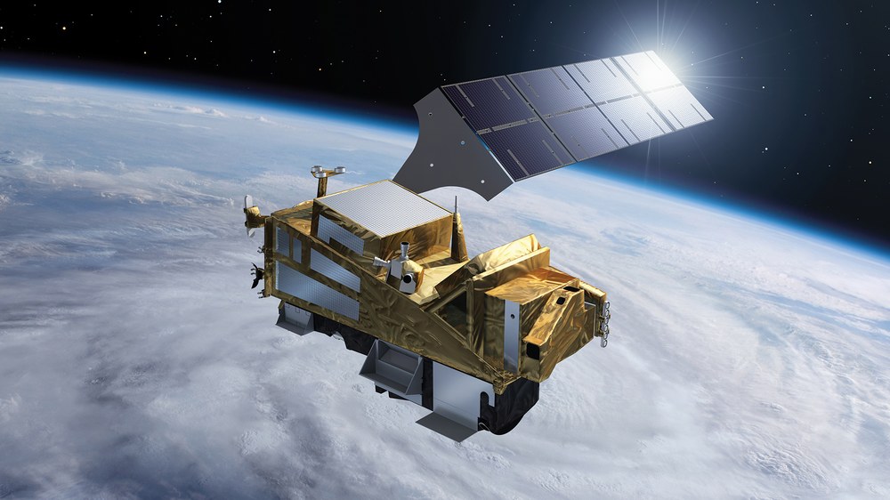
The METimage instrument after successful completion of the calibration campaign
From an orbit of 830 kilometres, the METimage multispectral radiometer captures a 2,670-kilometer-wide strip of Earth's surface every 1.7 seconds with a resolution of 500 metres. This is made possible by a rotating mirror that scans the entire surface of Earth in one day. In addition to detectors that operate in the visible spectral range, infrared detectors are also installed which operate at temperatures below minus 200 degrees Celsius. METimage captures 20 different spectral channels in a range from 443 nanometres to 13.345 micrometres. This represents a significant improvement over its predecessor model both in terms of the number of spectral channels and spatial resolution.
Image: 1/3, Credit:
Airbus
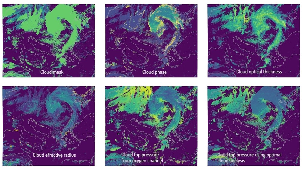
METimage measures clouds with unprecedented accuracy
Whether there’s sunshine, rain or thunderstorms, clouds have a major influence on the weather and climate. Many different small scale physical and chemical processes lead to uncertainties in current weather and climate models. METimage will measure clouds with unprecedented accuracy and thus contribute to more precise weather and climate forecasts.
Image: 2/3, Credit:
EUMETSAT 2024
Long-term commitment to global weather observation
METimage plays a central role in the Metop-SG (Second Generation) satellites, the first of which is due to be launched in 2025. These satellites will orbit Earth in a polar orbit, providing new and better global weather and climate data. This information is intended to improve weather forecasts in Europe and worldwide up to ten days in advance. The programme has a planned duration of 24 years with three identical pairs of satellites. METimage is the German contribution to the programme and will be manufactured and installed on all three satellite generations.
The state-of-the-art METimage multispectral radiometer is being handed over to EUMETSAT and ESA on 29 August 2024.
Its development and construction were managed by the German Space Agency at DLR, and it is financed by EUMETSAT and the German Federal Ministry of Transport and Digital Infrastructure.
METimage measures clouds, ice cover, land and ocean surface temperatures, vegetation and fires with unprecedented accuracy, enhancing the precision of weather and climate forecasting.
Focus: Space science, Earth observation, operational weather forecasting, climate change
Today, Germany will deliver a state-of-the-art measuring instrument – the METimage multispectral radiometer – to the European Organisation for the Exploitation of Meteorological Satellites (EUMETSAT) and the European Space Agency (ESA). The instrument measures clouds, ice cover, land and ocean surface temperatures, vegetation and fires with an unprecedented level of accuracy, paving the way for more precise weather and climate forecasting. The first flight model, worth approximately €300 million, is the German contribution to an international EUMETSAT programme scheduled to launch in 2025. Its design and construction were managed by the German Space Agency at the German Aerospace Center (Deutsches Zentrum für Luft- und Raumfahrt; DLR) and it is financed by EUMETSAT and the Federal Ministry of Transport and Digital Infrastructure. The instrument was developed and manufactured by Airbus in Friedrichshafen, Germany, and two additional flight models are still under construction.
With METimage, Germany is setting new standards in Earth observation and weather forecasting. This instrument epitomises cutting-edge German technology and will make a significant contribution to improving climate models and weather forecasting worldwide. It will also allow for more precise detection of extreme weather events, meaning the public can be warned at an earlier stage. METimage is a prime example of how investment in space technology directly benefits our everyday lives and future.
The number of severe weather events is continuously increasing. In order to be able to react faster and better to the consequences of climate change, we are all dependent on precise earth observation and weather information. Satellites play a key role in this, with approximately 85 percent of daily weather forecasts based on satellite data. METimage will play a decisive role in making our weather forecasts even more precise. Additionally, the instrument will supply vital data for global climate models, helping to inform actions to combat the effects of climate change.
Revolutionary technology for precise measurements
From an altitude of 830 kilometres, METimage scans a 2670-kilometre-wide strip of ground every 1.7 seconds with a resolution of 500 metres. It uses a rotating mirror that can scan the entire surface of Earth in one day. In addition to detectors that operate in the visible spectral range, the instrument also has infrared sensors that operate at temperatures below minus 200 degrees Celsius. As a result, METimage can record 20 different spectral channels in a range from 0.443 to 13.345 micrometres. This represents a major improvement on the previous model in terms of the number of spectral channels and spatial resolution.
Thanks to this technology, METimage can measure clouds, water vapour and aerosols, land and ocean surface temperatures, ice cover, vegetation and even fires with high precision. This high-quality METimage data will enable experts worldwide to achieve significant advances in weather and climate forecasting.
Long-term commitment to global weather observation
METimage will play a key role as an instrument onboard the Metop-SG (Second-Generation) satellites that make-up the EUMETSAT Polar System – Second Generation (EPS-SG) programme, providing new and improved global weather and climate data. The first Metop-SG satellite is scheduled to launch in 2025. The Metop-SG satellites will fly in a polar orbit around Earth, with their data intended to improve weather forecasting in Europe and worldwide up to ten days in advance. The programme is scheduled to run for 24 years, with three identical pairs of satellites. METimage is the German contribution to the programme and will be manufactured and installed in all three generations of satellites.

