Atlas reveals potential of solar energy installations in Germany
June 5, 2024 | Artificial intelligence combines Earth observation data
Atlas reveals potential of solar energy installations in Germany
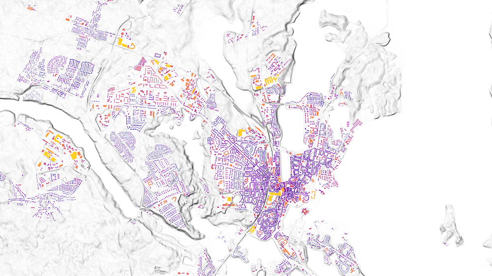
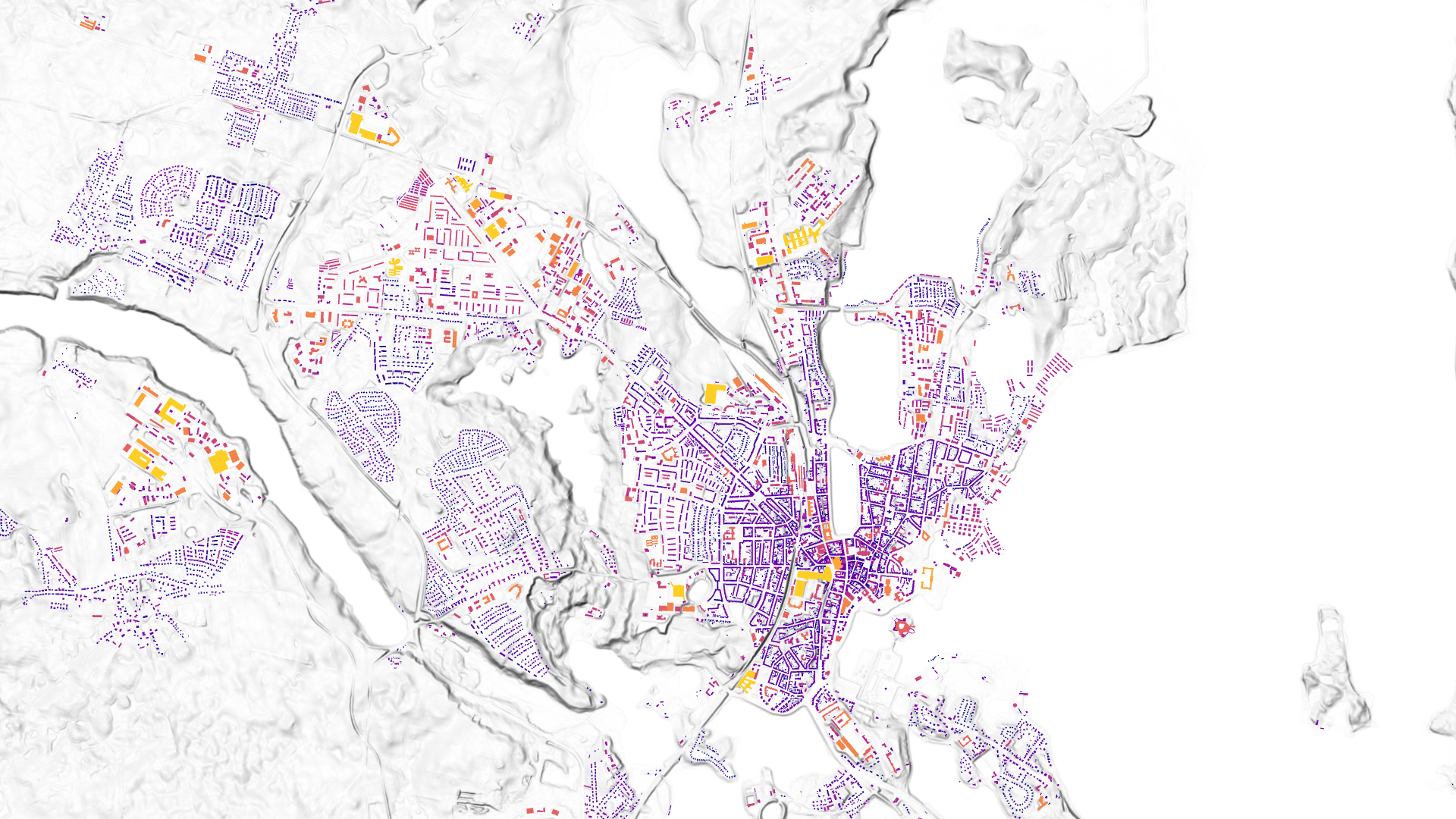
Solar roof potential in Stuttgart
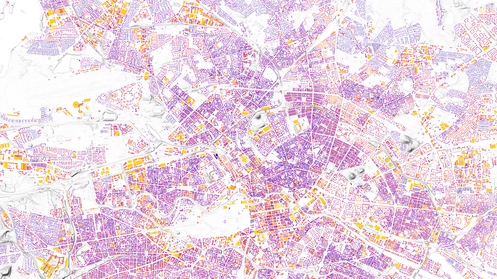
The EO Solar application shows the solar roof potential and solar roof expansion in Germany at various administrative levels down to buildings. This illustration shows the potential for Berlin. The yellow colour indicates that the solar roof potential – in other words the suitability for solar energy generation – is high. The other colours indicate a lower solar roof potential in shades up to dark blue. The results for the whole of Germany are available at eosolar.dlr.de publicly accessible.
The EO Solar application shows the solar roof potential and solar roof expansion in Germany at various administrative levels down to buildings. This illustration shows the potential for Berlin. The yellow colour indicates that the solar roof potential – in other words the suitability for solar energy generation – is high. The other colours indicate a lower solar roof potential in shades up to dark blue. The results for the whole of Germany are available at eosolar.dlr.de publicly accessible.
The EO Solar application shows the solar roof potential and solar roof expansion in Germany at various administrative levels down to buildings. This illustration shows the potential for Berlin. The yellow colour indicates that the solar roof potential – in other words the suitability for solar energy generation – is high. The other colours indicate a lower solar roof potential in shades up to dark blue. The results for the whole of Germany are available at eosolar.dlr.de publicly accessible.
Solar panel maps for the whole of Germany can aid policy makers.
The model identifies the orientation of roofs and determines potential energy output based on the hours of sunshine.
All publicly available information can be accessed at eosolar.dlr.de.
Focus: Earth observation, aeronautics, space, energy, energy transition, artificial intelligence, technology transfer
Which roofs are suitable for solar panel installations? Where are photovoltaic systems already in place? How much output could be achieved with solar panel arrays at specific locations? A map developed by the German Aerospace Center (Deutsches Zentrum für Luft- und Raumfahrt; DLR) provides the answers. DLR's researchers used machine learning methods to process current aerial photographs and geodata, enabling them to determine solar energy potential for the entire stock in Germany of around 20 million buildings. Results for the whole country are publicly available at eosolar.dlr.de.
The Solar Atlas is being presented at ILA in Berlin, where DLR is showcasing its research and development work in aeronautics, space, energy, transport, digitalisation and security. "Policy makers need precise information on the current inventory and growth potential in order to devise and implement effective strategies for expanding photovoltaic systems on roofs," explains Anke Kaysser-Pyzalla, Chair of the DLR Executive Board. "The satellite-derived information provided by DLR supports the energy transition and drives forward innovative products and business models. The DLR Solar Atlas shows how Earth observation can be used successfully for climate protection and the sustainable expansion of energy generation."
Multiple terabytes of data evaluated
Within the framework of the EO Solar project, researchers from the DLR Earth Observation Center (EOC) are evaluating and combining several terabytes of data from various sources to outline the current situation in Germany. These includes digital, distortion-free aerial photographs with a resolution of 20 centimetres and high-quality surface models with a resolution of one metre, provided by the Federal Agency for Cartography and Geodesy.
"To evaluate the current expansion potential for solar energy, we calculate the possible electrical output based on the hours of sunshine, radiation intensity, orientation of roof surfaces and shading from neighbouring buildings or vegetation," says Annekatrin Metz-Marconcini, who heads the EO Solar project. "DLR has also developed a process using artificial intelligence that enables us to identify roofs with existing solar panels anywhere in the world based on high-resolution remote sensing data. In Germany, we have included the Core Energy Market Data Register in the information that we use." The Core Energy Market Data Register lists all registered German solar panel installations and is updated on a daily basis.
Rather than building models, EO Solar uses digital terrain models, including those generated with the help of aircraft and satellites. These models automatically take account of shading from trees and the surrounding area, and the process can be extended to countries that do not have building models. Other than the roofs of buildings, the solar energy potential of open spaces can also be calculated using the same methodology and then taken into account for planning purposes.
Solar potential identified for municipalities, districts and federal states
Existing solar panel registers for federal states, districts or municipalities often differ in the level of information included, may lack detail or be limited to certain areas. By contrast, the DLR Solar Atlas provides an up-to-date, systematic mapping of the whole of Germany and as such offers policy makers and planners alike a basis for promoting the targeted expansion of photovoltaic systems.
DLR researchers have already created a similar map for Austria as part of an ESA project. For data protection reasons, it is not possible to map solar expansion potential for individual buildings on a publicly available website in Germany, so the expansion potential is shown at municipal, district or federal state level. The publicly accessible website eosolar.dlr.de has recently been set up for this purpose.

