NASA's VERITAS mission prepares for Venus on volcanic Iceland
August 10, 2023 | Research Flights and Field Campaign
NASA's VERITAS mission prepares for Venus on volcanic Iceland
Field campaign on Iceland to prepare for Venus
The centre of Iceland is a unique volcanic landscape with almost no vegetation, thus resembling the planetary surfaces of the Moon, Mars and Venus. This is why it became the target of a joint field campaign of NASA's Jet Propulsion Laboratory, DLR and international reserachers. In preparation for the upcoming NASA mission VERITAS to Venus, the expedition is measuring the physical and morphological characteristics of different types of volcanic landscapes. Solmaz Adeli and Stephen Garland from DLR's Institute of Planetary Research investigate the recent Holuhraun Lava flow emplaced in 2014 with the infrared camera V-EMulator, a prototype for the Venus Emissivity Mapper (VEM) that will be developed for VERITAS by DLR.
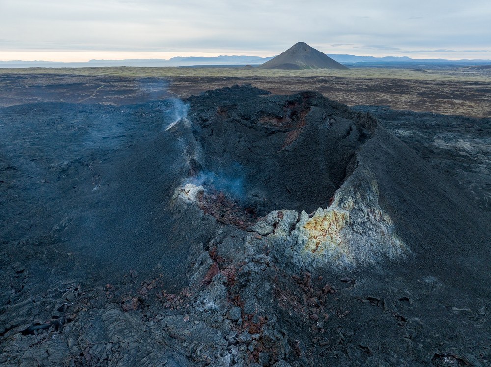
The Litli-Hrútur volcano in Iceland, where the DLR team is measuring infrared radiation
This image shows the small crater of the recent eruption of Litli-Hrútur on the Reykjanes peninsula. The eruption began on 31 July 2023, and slowly subsided in early August. Nevertheless, it provided DLR's V-EMulator team with good opportunities to measure recently solidified lava flows with high temperatures between 300 and 400 degrees Celsius, which is very close to the temperature on the surface of Venus (approximately 470 degrees Celsius). Fresh basalt lava at Litli-Hrútur had a temperature of over 1000 degrees Celsius, but the surface temperature quickly dropped to ambient temperature. Although the volcano is now dormant, the team from the DLR Institute of Planetary Research is looking for cracks that could be a window to material below that is still hot and approcimately the same temperature as Venus.
Your consent to the storage of data ('cookies') is required for the playback of this video on Quickchannel.com. You can view and change your current data storage settings at any time under privacy.
Europlanet2020
Video of Planetary Spectroscopy Laboratory transnational access facility at DLR Berlin.
Image: 12/12, Credit:
Europlanet/madebygravity.co
Why have Earth and Venus, two planets that are very similar in terms of size and mass, developed so differently over 4.5 billion years?
NASA's VERITAS mission aims to get to the bottom of these and other questions. DLR is an important partner in the mission.
In preparation for the return to Venus in the 2030s, a two-week field campaign is currently taking place in Iceland.
Volcanic Iceland is an excellent test environment in preparation for future missions to Venus.
Focus: Spaceflight, exploration, radar technology, planetary research
NASA's Venus Emissivity, Radio Science, InSAR, Topography And Spectroscopy (VERITAS) mission will orbit Venus and acquire infrared spectroscopy, radar imaging, topography, and repeat pass interferometry data. The German Aerospace Center (Deutsches Zentrum für Luft- und Raumfahrt; DLR) is a key partner in the mission and a field campaign currently under way in Iceland. DLR's advanced airborne F-SAR radar sensor is used for investigating and characterising surface properties to distinguish between various types of lava flows expected to be present on Venus in preparation for the return to Venus in the next decade. At the same time on the ground, DLR scientists use a field version of the Venus Emissivity Mapper (VEM) to map the near infrared spectral characteristics. The field campaign to Iceland is a joint expedition of NASA's Jet Propulsion Laboratory (JPL) in Southern California, DLR and a group of international scientists from the VERITAS science team.
Volcanic Iceland is an excellent testbed for scientific experiments to be carried out on future missions to Earth's neighbouring twin, Venus. "Characterising and measuring the extent and type of volcanic and tectonic processes on Venus is key to understanding the evolution of the surface of Venus and rocky planets in general", points out Sue Smrekar, the Principal Investigator for VERITAS at JPL. It was NASA's Magellan mission in the 1990s that gave the first detailed 'view' of the Venusian surface, which is shrouded beneath clouds of sulfuric acid. The mission's global topographic and radar maps unveiled a planet almost entirely resurfaced by volcanic activity in about the last half billion years. After Magellan, many questions still remain unanswered and the mission results spawned additional new questions: Why did Earth and Venus, almost identical in size and mass, follow completely different paths in their 4.5 billion year-long evolution? What happened during the four billion years before the last global resurfacing event? Finally, are there still active volcanos? These and many other questions motivate the current activities on Iceland that will facilitate future Venus investigations.
Radars are the way to see the surface of Venus at high resolution
DLR's Microwaves and Radar Institute has deployed its F-SAR radar system to acquire airborne radar imaging data similar to the data that will be delivered by future radar missions to Venus, namely NASA's VERITAS and ESA's EnVision.
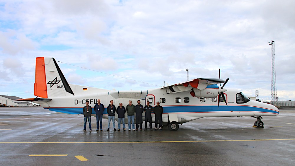
The radar and flight team of the Iceland campaign in front of the DO 228-212
The F-SAR radar system on board the Dornier DO 228-212 is used to acquire radar images from the aircraft. The twin-engine aircraft is used by DLR's Flight Experiments facility in Oberpfaffenhofen primarily for remote sensing missions using optical or radar-based systems. From left: the DLR Microwaves and Radar Institute team: Marc Jäger (F-SAR data processing), Martin Keller (F-SAR mission logistics), Daniel Geßwein (F-SAR radar operations) and Ralf Horn (F-SAR mission management); the NASA JPL team: Scott Hensley (VERITAS Project Scientist, EnVision Instrument Project Scientist); and the DLR Flight Experiments facility team: Miguel Pereda (Pilot), Thomas van Marwick (Pilot) and Edwin Wich (Onboard Engineering).
Data from DLR's F-SAR radar system will be used to estimate surface properties over lava flows and test algorithms and methods needed to meet VERITAS objectives. "DLR's Dornier 228-212 aircraft, operating at an altitude of 6000 metres above the ground, acquires radar data simultaneously at multiple frequencies including the ones used by VERITAS, EnVision and NASA's Magellan in the 1990s," explains Ralf Horn from DLR's Microwaves and Radar Institute.
Additionally, VERITAS scientists are in the field performing ground measurements and collecting rock samples from various types of solidified magma for laboratory analyses that will be used to devise better ways of interpreting the radar data acquired by the Venus missions. Data is being collected at two sites both from the air and on the ground: The first site is on the Reykjanes peninsula, which includes the recently active Litli-Hrútur volcano. The second site is in the Holuhraun area near the Askja volcano where an area larger than the size of New York's Manhattan Island was recently flooded by fresh lava. Holuhraun was formed in 2014/15 by an extraordinarily long and massive volcanic eruption. "The flexibility of the F-SAR radar to acquire interferometric and polarimetric data will be invaluable in developing algorithms for investigating Venus," said Scott Hensley of JPL, Project Scientist for VERITAS and VenSAR Instrument Project Scientist for EnVision.
The Venus Emissivity Mapper is the way to get compositional information
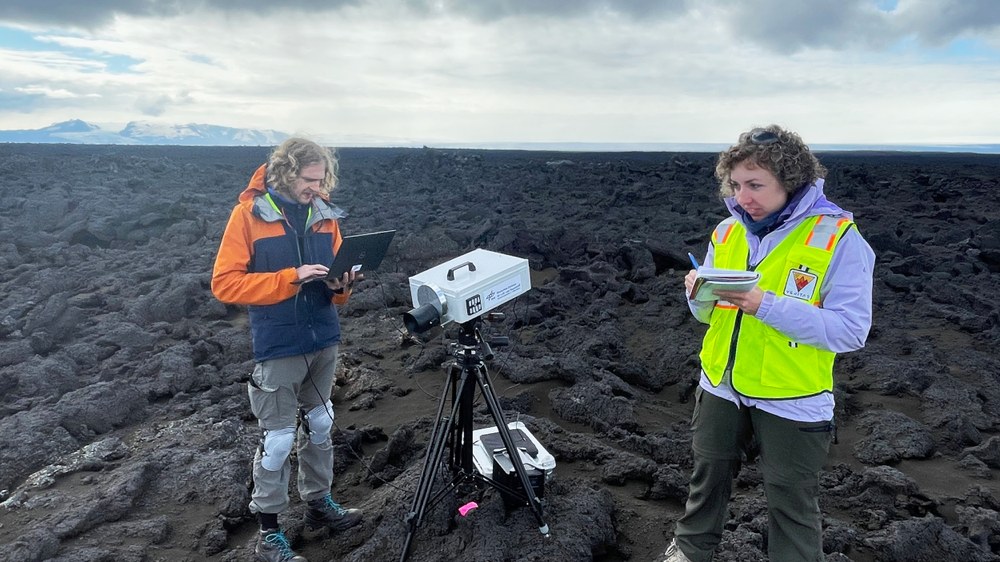
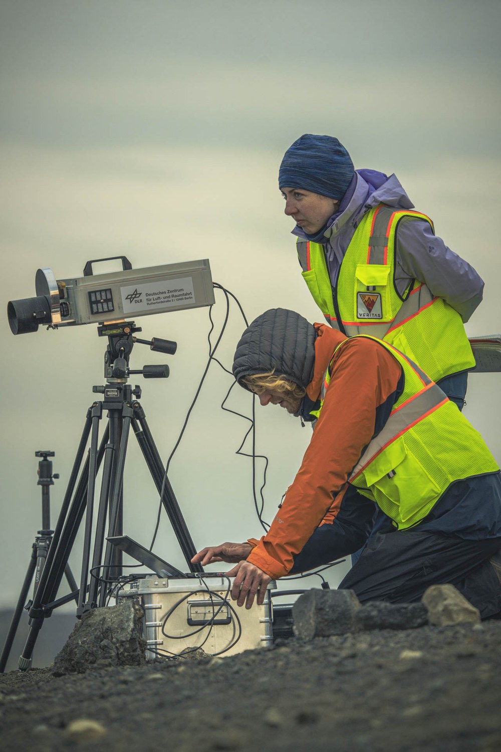
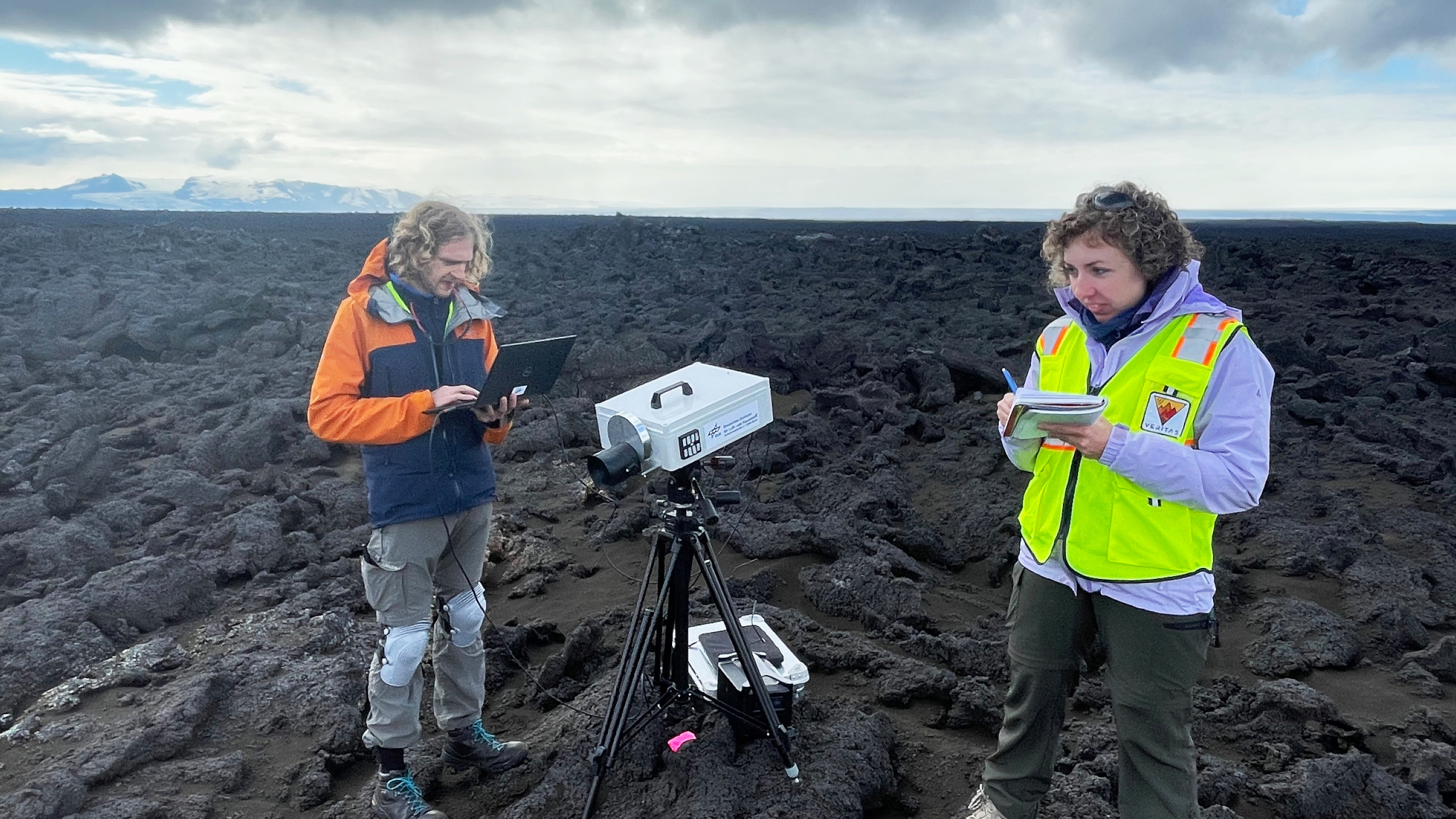
Conducting measurements with the V-EMulator
Solmaz Adeli (standing) and Stephen Garland (kneeling) of the DLR Institute of Planetary Research with the V-Emulator infrared camera.
Solmaz Adeli from DLR's Institute of Planetary Research is leading a project that investigates volcanic field sites during the Iceland campaign. "This will be of tremendous help to us in characterising the mineralogical composition and origin of the major geologic terrains on the Venusian surface when VEM delivers 'true' Venus data during the mission phase," she says. VEM is an infrared spectral imager developed by DLR´s institutes of Optical Sensor Systems and Planetary Research that is being provided by DLR for the NASA VERITAS and ESA EnVision missions. It is the first instrument specifically designed to map the rock types of the surface of Venus from orbit. "Mapping the rock type of Venus globally and deciphering the volcanic history and variability of the planet is one of the main objectives of the VERITAS and EnVision missions."
Adeli´s team uses the V-EMulator, a prototype of the VEM near-infrared multi-spectral camera that will fly on-board VERITAS to classify lava flows that range from very fresh terrains to areas that have been altered over time. 'Very fresh' for the team in Iceland means that the team will be able to measure hot, molten lava that is recently erupted from the Litli-Hrútur volcano since 10 July 2023.
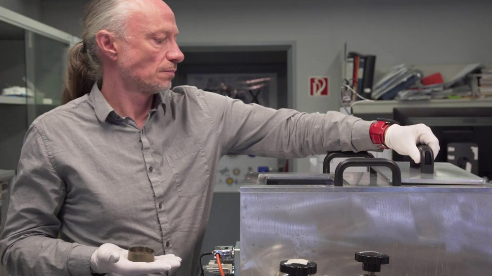
Samples of solidified lava will be collected and sent back to the Planetary Sample Laboratories (PSL) at DLR’s site in Berlin for analysis at temperatures as high as on Venus in the Venus emissivity chamber. The spectral characteristics of a rock at normal terrestrial temperatures differs from the signal at high temperatures like on Venus. It is necessary to understand exactly what is being measured to interpret the data properly.
As active volcanos on Venus are highly likely, another group of VERITAS scientists use data collected during the same field campaign to better understand volcanic activity on Venus. "We are investigating the infrared signal of active eruptions and searching for new lava flows," explains Nils Müller, a guest scientist at DLR's Institute of Planetary Research from Freie Universität Berlin. The Dyngjusandur sand sheet (a cold sand desert) and two fissure-fed lava flows, Holuhraun and Thorvaldshraun, are excellent analogues in Iceland to prepare for these studies, because these recent lava flows at the sites are sufficiently large and intense to be detectable if they were to appear on Venus.
The two-week long field campaign in Iceland, facilitated with the assistance of the University of Iceland and Europlanet, commenced on 31 July 2023. The first site investigated is the remote Holuhraun volcanic area near famous Askja volcano, adjacent to the largest glacier in Europe, Vatnajökull. Several selected sites that were pre-characterised with data of the German TerraSAR-X and TanDEM-X radar satellites are being investigated in great detail. Subsequently, the team transitions to the Reykjanes peninsula to get as close as possible to the Litli-Hrútur eruption.
VEM is one of the core scientific instruments of the VERITAS mission. It is a spectral camera that records near-infrared wavelengths. VEM is being developed by the DLR Institute of Optical Sensor Systems and the DLR Institute of Planetary Research. The team from the Institute of Planetary Research is responsible for defining the instrument's scientific objectives, validating them and operating it when in orbit around Venus. The team from the Institute of Optical Sensor Systems is responsible for the instrument’s design and development as well as its construction and verification. The optics including the spectral filter were provided by the French space agency CNES and the Laboratoire d'études spatiales et d'instrumentation en astrophysique (LESIA). In addition to NASA's VERITAS mission, DLR is also providing a very similar instrument for ESA's EnVision mission.
Contact
Philipp Burtscheidt
Senior editor DLR media relations
German Aerospace Center (DLR)
Corporate Communications
Linder Höhe, 51147 Cologne
Tel: +49 2203 601-2323
Ulrich Köhler
German Aerospace Center (DLR)
Institute of Planetary Research
Rutherfordstraße 2, 12489 Berlin
Solmaz Adeli
German Aerospace Center (DLR)
Institute of Planetary Research
Planetary Laboratories
Rutherfordstr. 2, 12489 Berlin
Nils Müller
German Aerospace Center (DLR)
Institute of Planetary Research
Extrasolar Planets and Atmospheres
Rutherfordstraße 2, 12489 Berlin
Ralf Horn
Head of the Airborne SAR Missions Group
German Aerospace Center (DLR)
Microwaves and Radar Institute
SAR Technology
Münchener Straße 20, 82234 Oberpfaffenhofen-Weßling
Marwan Younis
Head of the SAR Techniques Group; Project Manager for the Institute's contribution to VERITAS
German Aerospace Center (DLR)
Microwaves and Radar Institute
Radar Concepts
Münchener Straße 20, 82234 Weßling
Frank Probst
German Aerospace Center (DLR)
Flight Experiments Facility
Linder Höhe, 51147 Köln
Ian J. O’Neill
Media Relations Specialist
NASA Jet Propulsion Laboratory, California Institute of Technology
