The future of radar – scientific benefits and potential of TerraSAR-X and TanDEM-X


The German satellite duo TerraSAR-X and TanDEM-X have consistently delivered one-of-a-kind Earth observation data since 2007 and 2010, hence shaping the international research landscape. Now, scientific users from across the globe have gathered for the TerraSAR-X and TanDEM-X Science Meeting at the German Aerospace Center (Deutsches Zentrum für Luft- und Raumfahrt; DLR) in Oberpfaffenhofen, where they will discuss the results obtained from the data and define requirements for future remote sensing technology. Approximately 200 presentations between 17 and 20 October 2016 will describe state-of-the-art research, including insight from the areas of glaciology, hydrology, permafrost, sea ice, landslides, agriculture, forestry, volcanology, coastal and ocean research, geo-risks, and the methods applied to produce digital terrain models. Reporting live from the conference, the TanDEM-X Blog will present DLR talks from the Science Meeting and will outline how researchers around the world use data from the two radar satellites.
Research applications
Radar sensors are particularly important in the field of Earth observation, as they can deliver images irrespective of cloud cover and at any time of the day or night. From space, they are able to capture expansive areas of more than 100 kilometres in length. Moreover, the civilian radar satellites TerraSAR-X and TanDEM-X have measured the Earth with unprecedented accuracy over the course of their missions, contributing significantly to the scientific exploitation of the data. The satellites are still in operation and may indeed continue to be in the service of science for many years.
"International research facilities and organisations have been using the data acquired thus far to analyse, among other things, natural hazards such as earthquakes, volcanic eruptions and tsunamis. The strategies and measures developed on the basis of the data will become increasingly effective for the prevention or management of crises situations as the influential factors and correlations are known," explains Achim Roth from the The German Remote Sensing Data Center (DFD).
Users in the area of environmental protection have shown, among other things, that they can utilise the radar satellites to observe systematic deforestation or illegal felling of woodland areas. This applies in particular to rainforests, as their sheer magnitude and the prevailing weather conditions mean they can only be satisfactorily monitored using radar sensors. Forested areas are among the key fields of scientific concern, as their vast reservoirs of biomass directly influence the greenhouse gas effect: a substantial quantity of carbon dioxide is extracted from the woodlands during removal or decomposition of vegetation. Large-scale slash-and-burn practices are particularly critical, as the carbon dioxide stored in the forests is released directly, producing a correspondingly high concentration of the greenhouse gas carbon dioxide in the atmosphere. In contrast, planned deforestation – for instance as a source of timber – releases the natural carbon reservoirs contained in the woodland areas over a longer period and with a significant delay.
Impact on future research
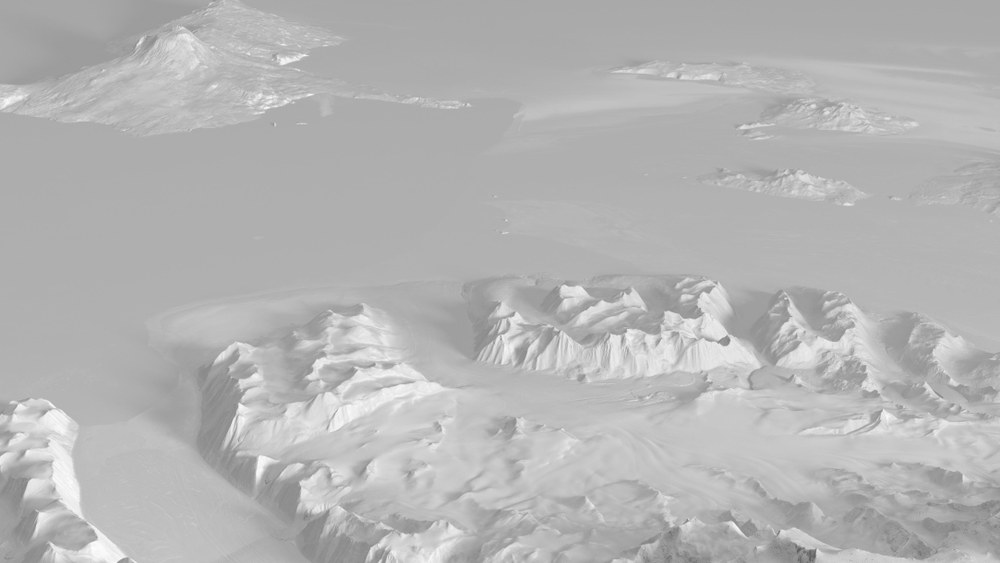
The view from space can provide precise information on the changes taking place in glaciers and ice shelves. The sometimes dramatic developments require regular monitoring and must be viewed in context with global warming. Here, the TanDEM-X elevation model is a true treasure trove of data; never before have Greenland and the Antarctic been surveyed so comprehensively and in such immense detail. Until now, the ice masses have been, from a scientific perspective, 'expanses of white' on a map of the world.
The polar regions present immense difficulties for radar imaging. Smooth, snow-bound surfaces do not contain any striking points of reference that would permit the superposition of several images. Moreover, an extremely precise allocation of the pixels would lead to image noise. "Our highly accurate data processing technologies here on the ground, combined with meticulous calibration of the radar instrument, allow us to observe glacier movements in the centimetre range, or to measure changes in elevation caused by ice melting in the metre range," says Irena Hajnsek from the DLR Microwaves and Radar Institute.The global TanDEM-X elevation model has now given climate researchers and geoscientists entirely new perspectives and opportunities for research. The insight they will acquire, and how this will influence the international research community, will be key issues at this Science Meeting as well as at future gatherings.

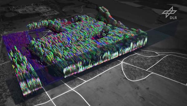
Polarimetric radar tomography: Biomass (medium resolution)
Your consent to the storage of data ('cookies') is required for the playback of this video on Quickchannel.com. You can view and change your current data storage settings at any time under privacy.
DLR
Looking ahead: HRWS and Tandem-L
Successful operation of the satellites in formation flight and the outstanding quality of data yielded by the TerraSAR-X and TanDEM-X missions represent a new milestone in the history of Earth observation. Seeking to expand the German radar satellite programme, DLR has set its sights on a successor programme, HRWS (High Resolution Wide Swath), to ensure continuity in Earth observation within the proven X-band frequency range. HRWS is scheduled for launch in 2022, and DLR is also involved in intense work on a revolutionary Earth observation system with the Tandem-L mission proposal.
Tandem-L, the highly innovative radar mission, aims to acquire important environmental and meteorological data on a global scale and in high temporal resolution. In the proposed mission, two radar satellites will map the Earth's landmass in three dimensions every eight days. This would enable timely and systematic mapping of dynamic processes as they unfold across the globe. Earthquake researchers and risk analysts would be able to detect deformations in the Earth’s surface in an accurate millimetre range. Glacier movements and melting processes across the polar regions would be measurable on a more regular and therefore precise basis. The plan proposes that the Earth observation data acquired by the three radar systems should be complementary.
Tandem-L will operate in a longer wavelength compared with the two current missions. An approximately 24-centimetre wavelength permits penetration through the vegetation, hence revealing surface structures in the subsoil. New technologies and imaging methods such as polarimetric SAR interferometry also enable three-dimensional mapping of forests. This could be used to calculate forest elevation and hence to produce an indirect estimate of biomass, a factor that is currently beyond the reach of science on a global scale.
Researchers from various Helmholtz Centres involved in preliminary mission studies will now present their findings in Oberpfaffenhofen, explaining the pivotal role of Tandem-L in providing answers to challenges faced by our environment. The Science Meeting offers the roughly 300 international participants a platform to identify all necessary issues of upcoming research and to launch the future of Earth observation.

Tandem-L: Animation (medium resolution)
Your consent to the storage of data ('cookies') is required for the playback of this video on Quickchannel.com. You can view and change your current data storage settings at any time under privacy.
DLR
About the mission
TanDEM-X is being implemented on behalf of DLR using funds from the Federal Ministry for Economic Affairs and Energy (Bundesministerium für Wirtschaft und Energie). It is a Public Private Partnership (PPP) project operated in conjunction with Airbus Defence and Space. DLR is responsible for providing TanDEM-X data to the scientific community, mission planning and implementation, radar operation and calibration, control of the two satellites, and generation of the digital elevation model. To this end, DLR has developed the necessary ground-based facilities. The DLR Microwaves and Radar Institute, the The Remote Sensing Technology Institute (IMF), the German Remote Sensing Data Center (DFD) and the DLR Space Operations and Astronaut Training (RB) in Oberpfaffenhofen are participating in the development and operation of the ground segment of TerraSAR-X and TanDEM-X. Scientific coordination is the responsibility of the DLR Microwaves and Radar Institute. Airbus Defence and Space built the satellites and is sharing the development and operating costs. The company is also responsible for the commercial marketing of the TanDEM-X data.
Access to the TanDEM-X Digital Elevation Model (DEM) is restricted – DLR supplies the data free of charge to scientific projects. Interested parties must, however, demonstrate the scientific nature of their project with a proposal and submit it to DLR. All information about this can be found on the TanDEM-X Science Service System: Information on availability products. Prospective commercial users of the data should contact DLR's project partner, Airbus Defence and Space, where they can purchase the data.
The TanDEM-X mission dataset has been created by a public-private partnership. On the basis of this cooperation, DLR provides the data to the scientific community, while their industrial partner, Airbus, is responsible for commercial distribution. It is planned that the DTM will be made generally available at a lower resolution, so that processing of the data will also be possible with standard computer technology.
