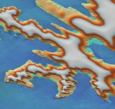
A snapshot of land and water – Franz Josef Land in the Arctic Ocean
A snapshot of land and water – Franz Josef Land in the Arctic Ocean
In this simultaneous acquisition by the twin satellites TanDEM-X and TerraSAR-X of Franz Josef Land in the Arctic Ocean, even the movement of the water is frozen. The adjustable flight formation and bistatic technique used by the two radar satellites make it possible for the data acquired to be analysed for a wide range of research on Earth. Bodies of water can be imaged without a problem for the first time. As if frozen in time, even the wave pattern of the sea can be recognised in the elevation model of the island group. Oceanography or climate researchers can also use such images to precisely analyse ocean currents. In this image the highest areas are coloured white – the colour scheme thus roughly corresponds to the formation of ice on the islands.

