Expertise
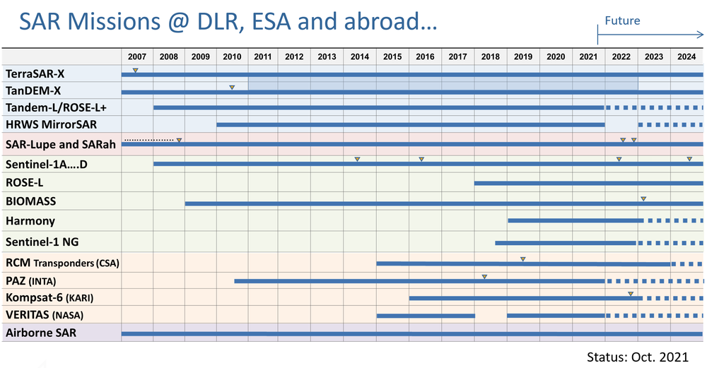
In the last 5 years, the Institute has actively participated and also initiated several SAR missions and research programs that are decisive for its long-term strategy. Important examples are TerraSAR-X, TanDEM-X, F-SAR (new airborne SAR) and SAR-Lupe.
It is also working on future remote sensing and reconnaissance systems, such as Sentinel-1 (Copernicus program of EU/ESA), TerraSAR-NG (follow-on to TerraSAR-X), HRWS (next generation X-band SAR with high-resolution wide-swath imaging), Tandem-L (L-band mission proposal) BIOMASS (ESA Earth Explorer mission), VABENE (DLR project for traffic monitoring with radar) and the SAR-Lupe follow-on program. These projects are accompanied by research programs that ensure the Institute keeps a step ahead in the development of new research fields. Examples of such research programs are bistatic and multistatic SAR systems, digital beamforming, inverse SAR, polarimetric SAR interferometry and tomography, calibration, signatures, propagation, antennas, as well as radiometry and imaging techniques for security.
Future Research Activities & Projects
Looking ahead to the next years, the Institute will continue to initiate and contribute to several projects that will be decisive for its long-term strategy. The table below shows the most important projects in the Institute.
The number of projects since 2006 has increased considerably. By means of the Institute’s contributions to the TerraSAR-X, TanDEM-X and SAR-Lupe projects, a highly qualified project team has been established. Due to the high degree of innovation in science and technology, the mission Tandem-L represents the most important project for the Institute in the years to come and can be seen as a next milestone in the national radar roadmap after TanDEM-X.
National Missions und Projects
TerraSAR-X and TanDEM-X are national high-resolution radar satellites launched in 2007 and 2010. The tandem operation of both satellites for DEM generation is planned until autumn 2016, but an extension of the operation is expected, because TerraSAR-X is still fully functional and has sufficient resources available. Although the nominal lifetime of TerraSAR-X is specified to be 5.5 years, an extension to more than 8 years is expected.
Tandem-L is a radar mission proposal in L-band. A pre-phase A study has been performed from 2008 to 2011. The study has been extended until 2014 in order to investigate a joint realization of Tandem-L with JAXA. The decision for implementation depends on an approval of the required funding which is expected to occur by the end of 2017.
The project RSE is fully funded by the German MoD and encompasses all activities of the Institute related to security and reconnaissance. It includes the technical support, engineering and mission analysis of SAR-Lupe and its follow-on system, as well as the passive microwave sensor developments.
Since 2009 the Institute has contributed to the TerraSAR-X2 phase A study. It is expected that TerraSAR-X2 will include new technological parts of a high-resolution wide-swath (HRWS) SAR system. Different to TanDEM-X, the requirements for TerraSAR-X2 are mainly driven by commercial applications. However, according to the PPP agreement, TerraSAR-X2 will ensure X-band data continuity for the scientific community.
European Projects
Sentinel-1A and Sentinel-1B are two C-band radar satellites from the EU/ESA Copernicus program. Sentinel 1A was launched in April 2014. The launch of the twin satellite Sentinel 1B is planned for 2016. The Institute’s contribution lies in the definition of the end-to-end system calibration concept and algorithms. The Institute has already contributed in the calibration during the commissioning phase of the Sentinel-1 satellites and will also contribute to the calibration of the successor satellites of ESA.
BIOMASS (P-band SAR, fully polarimetric) is an Earth Explorer mission recommended for implementation. The Institute is involved in the calibration and several science studies for the two radar missions. For BIOMASS, the Institute is the prime contractor for the development of the complete end-to-end mission performance simulator. Further activities include flight campaigns with the airborne SAR.
The Institute also contributes to the Spanish PAZ satellite with the delivery of the SAR related software modules for instrument operations and calibration. The PAZ satellite is a TerraSAR-X based satellite, the launch is scheduled for 2015.
DLR Internal Projects
F-SAR is the new airborne SAR system of DLR that became fully operational by 2012. It is planned to expand the F-SAR system to include a digital beamforming capability by 2015. Several internal and external flight campaigns have already been executed with F-SAR since 2008, the intensive operational phase started in 2012.
F-SAR has been extended to a 4-channel system for road traffic monitoring (DLR internal project VABENE). The Institute has submitted a proposal for developing a low-cost, compact airborne SAR for road traffic monitoring based on the F-SAR technology. This project has started mid-2012.
The DLR projects MEPHISTO and ITEM-FK deal with UCAVs (Unmanned Combat Aerial Vehicles) and agile missiles, respectively. Several disciplines, like aerodynamics, flight control, material sciences, actuation, radar and infrared signatures are represented. The Institute's contributions are investigations concerning radar signatures, radar detection probabilities and radome microwave transmission.
Research Programs
The above mentioned projects are accompanied by several research programs.
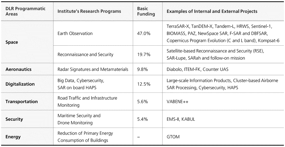
The table on the top summarizes the internal and external projects as well as the research programs that are funded by the DLR program directorates in the areas of space, aeronautics and transportation. Examples of research programs are new SAR concepts, signal processing, airborne SAR, information retrieval, calibration, and signatures. The research programs are closely interconnected with the project activities.
As a matter of fact, most of the current projects of the Institute have started as research programs with typical durations of 2 to 5 years. Due to the long-term aspect of the Institute’s projects, it has developed a roadmap for the future radar activities jointly with its partners in industry and research. This roadmap is being updated on a regular basis. As of today, the Institute has more than 70% of its resources allocated to DLR projects and external contracts. Considering the success in the approval of the new mid-term and long-term projects, it is expected that this percentage will be maintained above 70% in the next 5 years.


