Nereidum Montes – a mountain landscape formed by water, ice and wind
September 3, 2020 | Mars Express mission
Nereidum Montes – a mountain landscape formed by water, ice and wind
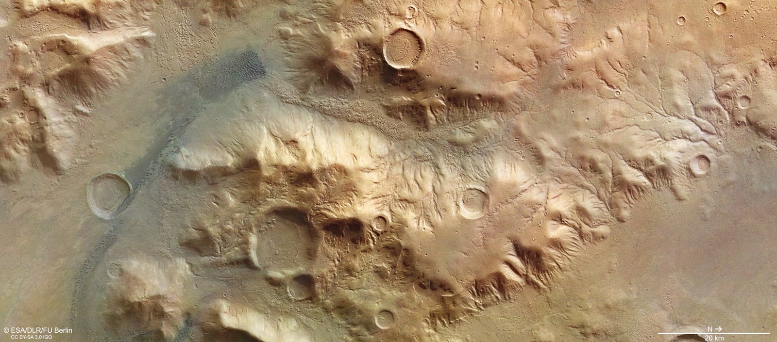
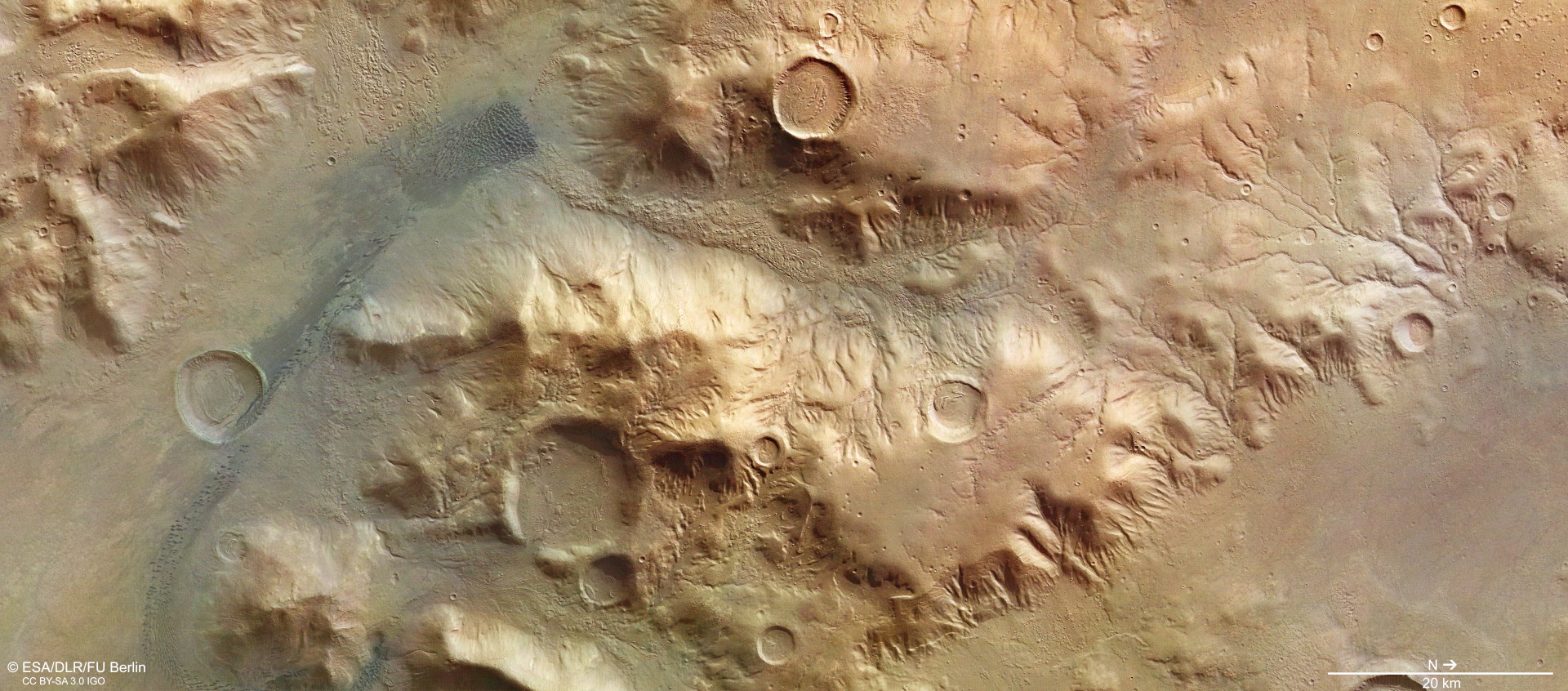
Vertical plan view – part of Nereidum Montes in true colour
This vertical plan view of an approximately 130- by 60-kilometre area of Nereidum Montes – corresponding to an area roughly half the mountainous Austrian state of Tirol – clearly shows how the landscape at the crater edge has been shaped by various geological processes since the formation of the Argyre impact basin four billion years ago. Water, ice (both on and beneath the surface) and, more recently, wind have all left their mark. A striking network of small, branching valleys on the right-hand side of the image attests to water having flowed over the surface from the 4000-metre-high edge of Argyre and down the mountain slopes into the basin, carving out erosion gullies and creating small valleys.
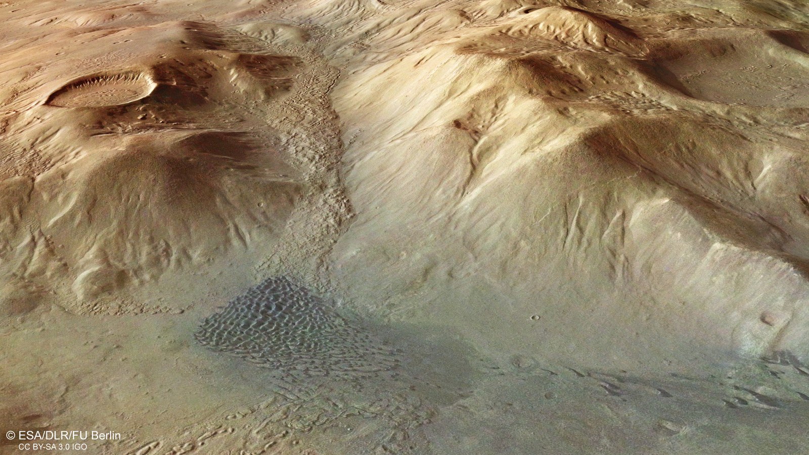
This oblique perspective view into a deeply carved valley bordered by mountains that are over 3000 metres tall shows large-scale movements of material, created by landslides. This material accumulated on the valley floor, where it was exposed to further processes of weathering and erosion. A small impact crater on the massif at the upper left of the valley is, like many other craters in this area, filled with material and exhibits a striking concentric pattern on its surface. Such markings indicate the former presence of glaciers covered by rock debris, known as rock glaciers. The material that slipped into the valley could also have covered ice that might still exist today. Last but not least, the dark dune fields at the entrance to the valley testify to the power of the wind to transport grains of sand over large distances and around obstacles. The greyish-black dune sands commonly found on Mars are of volcanic origin.
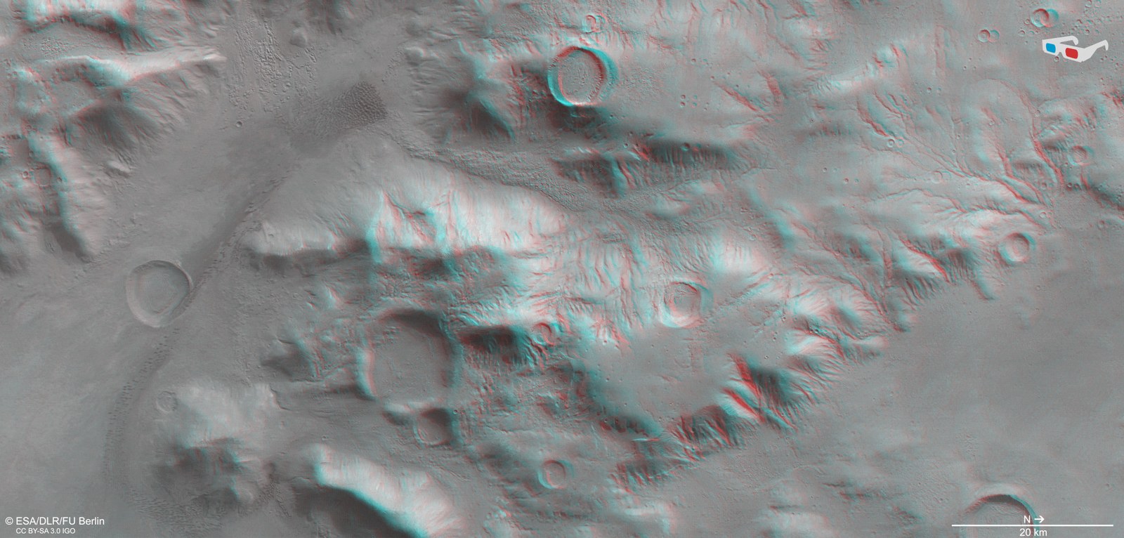
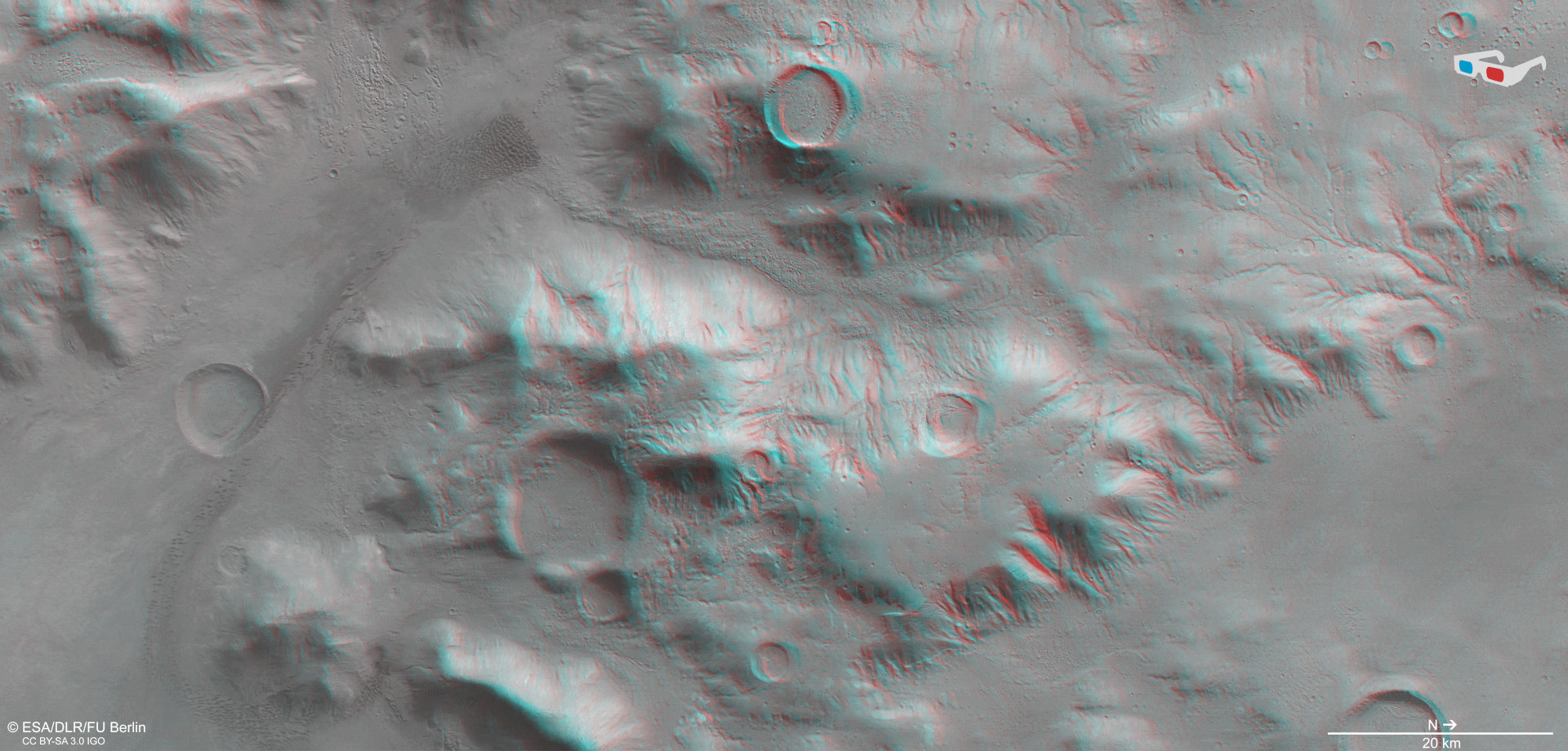
3D view (anaglyph image) of part of Nereidum Montes
Anaglyph images can be created using data acquired by the nadir channel (the field of view of which is oriented aligned perpendicular to the surface of Mars) of the High Resolution Stereo Camera operated by DLR on board ESA’s Mars Express spacecraft and one of the four oblique-viewing stereo channels. When viewed with red-blue or red-green glasses, these images give a three-dimensional view of the landscape. North is to the right of the image. The high image resolution clearly captures the diverse topography of this region. The state of erosion makes it possible to determine the ages of the impact craters, the drainage channels and small valleys on the mountain slopes, which were created by water flowing over the surface.
These images of Mars, acquired by the DLR-operated HRSC instrument, show part of the Nereidum Montes mountain range.
This region has been shaped by various geological processes, with water, ice (both on and beneath the surface) and, more recently, wind all contributing to the erosion.
The HRSC has been mapping the Red Planet with unprecedented resolution, in three dimensions and in colour, since 2004 – as part of ESA’s Mars Express mission.
These images, acquired by the High Resolution Stereo Camera (HRSC), show part of the Nereidum Montes region. Wind, water, ice and tectonic forces have created a highly diverse landscape. The HRSC has been mapping the Red Planet with unprecedented resolution, in three dimensions and in colour, since 2004 as part of ESA's Mars Express mission. It was developed at the German Aerospace Center (Deutsches Zentrum für Luft- und Raumfahrt; DLR) and is operated by the DLR Institute of Planetary Research. Mars Express delivers new data about the geology, mineralogy and atmosphere of Mars to shed light on the climate history of the Red Planet and clarify the role of water and determine the location of whatever water is left.
The Martian 'Alps'
Nereidum Montes is part of the northern rim of Argyre Basin. With a diameter of 1800 kilometres and a depth of up to five kilometres, Argyre is the second-largest impact basin on Mars (the biggest being Hellas Planitia). Similar to the Alps, the Nereidum Montes mountain chain extends for over 1100 kilometres in an elongated arc, running parallel to the edge of the basin. Similar to the mountainous areas of Europe, there are individual massifs that are up to 4000 metres high.
However, the Alps were formed by a very different process to the one that created the ring mountains of Nereidum Montes. The latter were originally the result of an extremely large asteroid impact. The impact was so enormous that it not only formed a bowl-shaped basin several kilometres deep, but also created several concentric rings of mountains at the basin edge. These have acquired a terrace-like structure due to tectonic landslide processes, which moved entire blocks of the surface. By contrast, the Alps were formed when the African continental plate collided with the Eurasian plate, crumpling the collision zone into fold mountains almost 5000 metres high. These are still growing by approximately one centimetre per year, although they are being eroded at the same time.
The 'Silver Plain' and the 'Nereid Mountains'
Before Mars could be closely examined by spacecraft, even Earth's most powerful telescopes could only discern major geological formations. These included the Argyre Basin, but scientists were unable to draw any conclusions about its topography on the basis of their observations by telescope.
Chryse and Argyre were two mythical islands that Pliny the Elder (23–79 AD) described as being located where the Indus flows into the Indian Ocean, and which were said to harbour large deposits of gold (in Greek, chrysos) and silver (argyros). These names were incorporated into the earliest cartographic representations of Mars. Giovanni Schiaparelli (1835–1910) made the most of Mars' proximity to Earth in 1877 to conduct extensive observations and map Mars in detail for the first time. At that point, the 'Golden Plain', or Chryse Planitia, further north was also included in the nomenclature. Nereidum Montes, or 'Mountains of the Nereids' (named after the 50 daughters of Nereus, a sea god in Greek mythology, and his consort Doris, the daughter of Oceanos and Tethys), received its name only in the space age, when it became possible to identify smaller regional structures.
The images show a region characterised by an array of geological processes that occurred after the formation of the Argyre Basin four billion years ago. Water, ice (both on and beneath the surface) and, more recently, wind have all contributed to the erosion that has taken place here. Argyre was originally deeper than it is today. Eroded rock was transported into the basin by glaciers and flowing water, so that it gradually became partially filled.
Indications of ice beneath the surface
A striking network of small, branching valleys on the right-hand side of Image 1 attest to water having flowed over the surface from the edge of Argyre and into the basin. This came either from rainfall in the early days of Mars or from melted glacial ice. To this day, these drainage networks document the planet’s water-rich past.
There has been a long and intensive debate as to whether there was actually a significantly warmer climate (warm and wet) in the early days of Mars. This would have enabled a water cycle with precipitation and a network of bodies of water on the surface, either over a longer period or perhaps just episodically. Alternatively, given that the thin atmosphere offered little in the way of a greenhouse effect, the conditions may have been cold and wet, leading to ice age processes with, at most, precipitation of snow and the associated glacial phenomena. Sporadic volcanic activity or impacts events would have triggered thawing processes that melted the ice on the surface and subsurface, thus causing water to flow.
The latest findings show that the many dry river valleys on Mars were formed by at least four different run-off processes: surface run-off due to precipitation, melting glaciers, subglacial run-off beneath glacial ice masses and escaping groundwater (which in turn may have been formed by melting ground ice). Nereidum Montes is considered to be a key region for thoroughly testing these hypotheses. Due to its morphology, which is thought to be of glacial origin, it is likely that its features were formed by melting glacial ice.
Most of the impact craters in this region are filled with a material that has a striking concentric pattern on its surface. Such structures indicate the former presence of glaciers covered by rock debris, known as rock glaciers. The resulting landforms can also be seen as large-scale deposits in valleys between mountain ranges. It is thought that these landforms still contain water ice deep under a layer of debris that prevents sublimation – the vaporisation of ice in the low-pressure Martian atmosphere.
The power of the wind
Last but not least, the dark dune fields on the left-hand side of Image 1 testify to the power of the wind to transport grains of sand over large distances and around obstacles. The greyish-black dune sands that are common on Mars are of volcanic origin. They consist primarily of old, once-buried volcanic ash, which was often brought up from beneath the Martian surface by impact events. These sands often contain fragments of crushed lava rock and volcanic glass. As they were covered by Martian surface materials for a time, they were not transformed into lighter minerals by the action of water.
Based on the dune types, the direction of the wind that has formed the various dunes can easily be determined. In this example, some individual, crescent-shaped dunes, known as barchans, can be seen. These have grown together to form a barchanoid dune field at the end of the valley. In this case, the wind came from the southeast (bottom left in Image 1), blew into the valley, drove the sands before it and deposited most of the material at the foot of the mountains.
Image processing
These images were acquired by the High Resolution Stereo Camera (HRSC) on 7 August 2015 during Mars Express Orbit 14,709. The ground resolution is approximately 15 metres per pixel and the images are centred at roughly 312 degrees east and 39.5 degrees south. The perpendicular colour view was generated using data acquired by the nadir channel, the field of view which is aligned perpendicular to the surface of Mars, and the colour channels of the HRSC. The oblique perspective view was computed using a Digital Terrain Model (DTM) and data acquired by the nadir and colour channels of the HRSC. The anaglyph, which provides a three-dimensional view of the landscape when viewed using red-green or red-blue glasses, was derived from data acquired by the nadir channel and the stereo channels. The color-coded topographic view is based on a DTM of the region, from which the topography of the landscape can be derived. The reference body for the HRSC DTM is a Mars equipotential surface (Areoid).
The HRSC was developed and is operated by the German Aerospace Center (DLR). The systematic processing of the camera data was performed at the DLR Institute of Planetary Research in Berlin-Adlershof. Personnel at the Department of Planetary Sciences and Remote Sensing at Freie Universität Berlin used these data to create the image products shown here.
The HRSC experiment on Mars Express
The High Resolution Stereo Camera (HRSC) was developed by the German Aerospace Center (Deutsches Zentrum für Luft- und Raumfahrt; DLR) and built in collaboration with partners in industry (EADS Astrium, Lewicki Microelectronic GmbH and Jena-Optronik GmbH). The science team, which is headed by Principal Investigator (PI) Ralf Jaumann, consists of 52 co-investigators from 34 institutions in 11 countries. The camera is operated by the DLR Institute of Planetary Research in Berlin-Adlershof.
