Real-time aerial imaging makes a significant contribution to the understanding of the situation in a disaster area. The characteristics of RPAS mean that they are increasing in significance in this context. As part of the DRIVER+ project, the research aircraft D-CODE will be used as a RPAS demonstrator in order to record aerial images of a crisis area and make them available to rescue teams on the ground in near real-time.The mission flight will take place in non-separated airspace. A significant first step for the use of unmanned aircraft (RPAS) in crisis management.
Project description
Flooding, storms, extreme winter weather, forest fires, earthquakes or technical disasters repeatedly affect wide areas of Europe. The European Union is funding the project "Driving Innovation in Crisis Management for European Resilience" (DRIVER+) as part of the 7th Framework Programme (FP7) in order to be better prepared for these events across borders and to be able to organise the necessary help efficiently. The project began in September 2017 with a total of 31 European project partners from 14 countries. DRIVER+ is thus one of the world's biggest publicly funded demonstration projects in the field of crisis management.
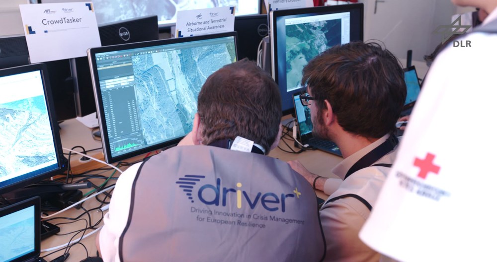
In the EU project DRIVER+, DLR provided real-time aerial images in a disaster control exercise in Eisenerz/Austria in order to provide crucial support for situation recording and rescue logistics of disasters in the future.
DLR research aircraft D-CODE used as a drone demonstrator for future disaster control
Your consent to the storage of data ('cookies') is required for the playback of this video on Youtube.com. You can view and change your current data storage settings at any time under privacy.
DLR research aircraft D-CODE used as a drone demonstrator for future disaster control
In the EU project DRIVER+, DLR provided real-time aerial images in a disaster control exercise in Eisenerz/Austria in order to provide crucial support for situation recording and rescue logistics of disasters in the future.
With the participation of DLR, the EU project DRIVER+ brings together a variety of technologies for crisis management in the wake of a disaster and applies them in four Europe-wide (Poland, France, The Netherlands, Austria) joint demonstrations. Real-time aerial imaging makes a significant contribution to the understanding of the situation on the ground in a disaster area and therefore to the targeted planning of response personnel deployment. The use of RPAS is becoming increasingly significant in particular in civil disaster control and crisis management. This is due on the one hand to the fact that they can be deployed even in areas which are hazardous or very difficult to access and, on the other, to the opportunity which they provide for observing at-risk or affected areas over a long period of time.
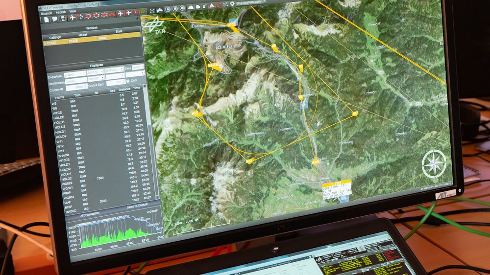
It is on this point that DLR's work is focused. For DRIVER+, the research aircraft D-CODE will be equipped with camera systems provided by DLR's Earth Observation Centre (EOC) in Oberpfaffenhofen. Using the 3K camera system employed here an area of 80 square kilometres can be imaged, geo-referenced aerial images can be produced and the results transmitted to the ground station via a data link – all in approx. two minutes, depending on flight altitude. In order to test unmanned flights in controlled airspace and for the demonstration of RPAS flights for disaster control, the research aircraft D-CODE, a Dornier 228, was modified in such a way that flight instructions from the ground can be received and processed. Real-time aerial images are sent to the ground station for evaluation during the flight in order not only to establish the area affected but equally to spot people in the crisis area. The aircraft's flight and mission planning takes place from the U-FLY ground station for unmanned aircraft at the Institute of Flight Guidance in Braunschweig.
DRIVER+ (Driving Innovation in Crisis Management for European Resilience)
Participants
ATOS Spain SA (Spanien) - Projektkoordinator AIT Austrian Institute of Technology GmbH (Österreich) ARTTIC (Frankreich) Association pour la Recherche et le Développement des méthodes et processus Industriels – ARMINES (Frankreich) Austrian Red Cross Research GmbH (Österreich) Centro de Innovación Tecnológica para Logística y Transporte Mercancías Carretera (Spanien) Dansk Røde Kors (Dänisches Rotes Kreuz) (Dänemark) Deutsches Zentrum für Luft- und Raumfahrt e.V. – DLR (Deutschland) DIN Deutsches Institut für Normung e.V. (Deutschland) Disaster Waste Recovery (Großbritannien) Ecorys Nederland B.V. (Niederlande) Edisoft (Portugal) Entente pour la Protection de La Forêt Méditerranéenne (Valabre) (Frankreich) Frequentis AG (Österreich) GMV Aerospace and Defence SA Unipersonal (Spanien) HKV Lijn in Water B.V. (Niederlande) ITTI sp. z o.o. (Polen) JRC (Gemeinsame Forschungsstelle), Europäische Kommission (Italien) Magen David Adom in Israel (Israel) Nederlandse Organisatie voor Toegepast Natuurwetenschappelijk Onderzoek – TNO (Niederlande) - Projektleiter und Technischer Leiter Peace Research Institute Oslo – PRIO (Norwegen) Public Safety Communication Europe Forum (Belgien) Stadt Den Haag (Niederlande) Thales Communications & Security (Frankreich) The Centre for Security and Defence Management (CSDM) (Bulgarien) The Estonian Academy of Security Sciences (EASS) (Estland) The European Organisation for Security SCRL (Spanien) The Main School of Fire Service (SGSP) (Poland) The Space Research Centre of Polish Academy of Sciences (SRC PAS) (Polen) Westfälische Wilhelms-Universität Münster (Deutschland) XVR Simulation (Niederlande)

