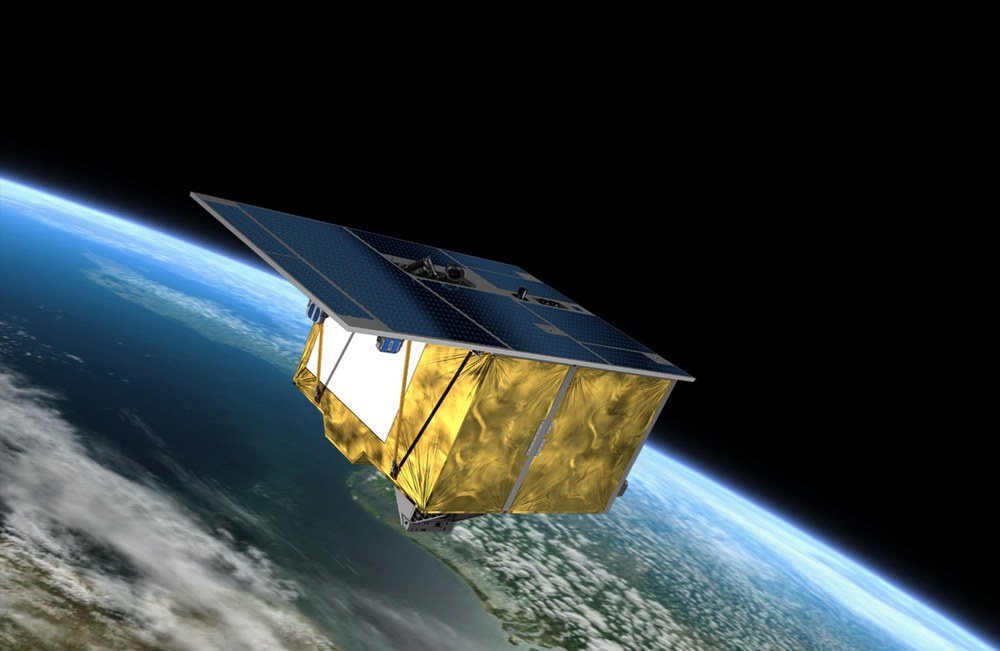
The main objective of the hyperspectral satellite mission EnMAP (Environmental Mapping Analysis Programme) is to study a broad area of Earth's land surface ecosystem. The hyperspectral instrument analyses the solar radiation reflected by Earth at wavelengths ranging from visible light to short-wave infrared – at a hitherto unparalleled spectral resolution. light to short-wave infrared – at a hitherto unparalleled spectral resolution. This information can be used to make precise statements about conditions on Earth's surface and how they are changing. The satellite was launched to space from Cape Canaveral in Florida on 1 April 2022 aboard a Falcon 9 rocket from the US aerospace company SpaceX. The mission is scheduled to last at least five years.
Data on the nutrient supply of plants or water quality of lakes
Conventional multispectral sensors record the radiation reflected from Earth in just a few, very broad spectral channels. These data can be used, for example, to derive reliable qualitative information about land cover and its spatial distribution. However, to obtain quantitative information concerning, for example, the supply of nutrients to crops, the water quality in lakes or the identification of soil minerals, high-resolution spectral data are required.
The data from EnMAP will be used in many areas of research, for example in geology, agriculture and forestry, soil science and also in the exploration of coastal areas and inland water bodies. Satellite-based measurements are of great importance to researchers because they can be carried out frequently and repeated at regular intervals over a target area. This enables the mission to optimise research into the interlinked processes of the biosphere and geosphere – in contrast to ground-based and airborne sensors and measuring instruments, which can only deliver a very time-limited data set of a small area. EnMAP is therefore making an important contribution to securing vital resources for the future.
The environmental satellite is equipped with an imaging hyperspectral instrument that covers the spectral range from 420 to 1000 nanometres in 95 channels and from 900 to 2450 nanometres in 135 spectral channels, with high radiometric accuracy and measurement stability for the reflected solar intensity. EnMAP will orbit the Earth at an altitude of approximately 650 kilometres. When recording data, the hyperspectral instrument will cover a strip of Earth's surface with a width of 390 kilometres and a ground resolution of 30 metres by 30 metres. Its recording capacity is designed to map strips with lengths of up to 1000 kilometres per orbit and a maximum strip length of 5000 kilometres per day.
Every material on the Earth's surface reflects sunlight in a way that is characteristic of it, a so-called spectral signature. The EnMAP environmental satellite can "read" this signature with the help of its measuring instrument. However, in order not to confuse it with other elements, these signatures must be scanned very precisely. This is done with the help of multi-channel images (so-called hyperspectral images). The materials and composition of various land surfaces, both natural and urban, can then be identified and qualified using special evaluation methods.
Environmental satellite EnMAP - The mission video
Your consent to the storage of data ('cookies') is required for the playback of this video on Youtube.com. You can view and change your current data storage settings at any time under privacy.
Environmental satellite EnMAP - The mission video
Every material on the Earth's surface reflects sunlight in a way that is characteristic of it, a so-called spectral signature. The EnMAP environmental satellite can "read" this signature with the help of its measuring instrument. However, in order not to confuse it with other elements, these signatures must be scanned very precisely. This is done with the help of multi-channel images (so-called hyperspectral images). The materials and composition of various land surfaces, both natural and urban, can then be identified and qualified using special evaluation methods.
The German Space Agency at DLR is responsible for managing the project. The scientific management of the EnMAP mission is carried out by Sabine Chabrillat, German Research Centre for Geosciences Potsdam (GFZ). The GFZ is providing the chair of the scientific advisory committee to support the mission and its utilisation. OHB-System AG was awarded the contract for the development and construction of the satellite and the hyperspectral instrument.
Three DLR institutes and facilities have been commissioned for the construction and operation of the ground segment. The German Space Operations Center in Oberpfaffenhofen will conduct and monitor satellite operations, while the German Remote Sensing Data Center and the DLR Remote Sensing Technology Institute will archive, process and validate the received satellite data and make them available to the scientific community. Companies and public authorities will also test the data and use them to prepare future services.
The use of EnMAP hyperspectral data by universities and scientific institutions and the development of special applications will be supported by BMWK funding programmes.
Launch
2022
Orbital altitude
640 km
Orbit type Inclination
Inclination 97.98 °,
Sun-synchronous orbit, 11:00 local time descending node