
MERLIN

One of the aims of the three-year mission is to create a global map of methane concentrations. The mission will also provide information on the regions of Earth where methane is released into the atmosphere (methane sources) and the areas where it is removed from the atmosphere (methane sinks).
Why methane measurements?
Methane (CH4) is the second largest contributor to anthropogenic global warming after carbon dioxide (CO2). The Intergovernmental Panel for Climate Change (IPCC), a scientific body set up by the United Nations, has recognised methane as having 25 times more potential to cause global warming than carbon dioxide. Since the beginning of industrialisation, the global methane concentration in the atmosphere has doubled due to anthropogenic emissions – the carbon dioxide concentration has ‘only’ increased by 30 percent.
The data from the recent past is particularly worrying: in 2007 and 2008, atmospheric methane concentrations rose again significantly after remaining roughly constant for more than ten years. Since 2015, the annual increase has once again risen significantly. Although there are various theories as to the possible reasons for this increase, the actual cause of this phenomenon is still unknown. The mission aims to shed light on this.
The greenhouse gas methane
The greenhouse gas methane is usually produced during decomposition processes, in other words the decomposition of biological material by microorganisms in an oxygen-free environment. This occurs, for example, in the bottom sludge of bodies of water. The most important natural sources are wetlands, especially in the tropics and northern latitudes. The main anthropogenic sources of methane are oil and gas extraction, mining and landfill sites, as well as rice cultivation and livestock farming.
In the future, the concentration of this greenhouse gas could continue to increase even more dramatically. If the permafrost soils of Russia and Canada thaw as the planet warms, melt pools will form and methane will be produced by decomposition processes. This methane will escape into the atmosphere and further exacerbate the climate situation. If the oceans warm up due to climate change, enormous quantities of methane will be released there as well, quantities that have until now been stored in the frozen state as so-called gas hydrates in the sediment layers of the world's oceans. These two processes represent a major uncertainty in the models for the future development of the global climate.
Using the current climate models, it is very difficult and uncertain to calculate how much methane will actually be released into the Earth's atmosphere. During the thawing of permafrost soils, for example, this depends on the conditions of the various methane formation processes. If, for example, puddles form, methane is produced at the bottom of these puddles. When the permafrost thaws, however, more carbon dioxide is produced. This knowledge gap can be remedied by sufficiently precise information on the global distribution of methane in the lower atmosphere, which, according to the current state of knowledge, is only expected from the MERLIN data.
A better understanding of the methane cycle is urgently needed in order to reliably predict climate change and effectively protect the climate. The high-precision global measurement and mapping of the methane content in the Earth's atmosphere can only be carried out from space, as the Earth must be monitored continuously and over a large area for this purpose. In particular, key regions such as tropical wetlands, rainforests and permafrost regions are difficult to access without satellites. The polar regions are difficult to observe from space using conventional methods due to conditions such as the low position of the sun or the polar night. This is where MERLIN can make a decisive contribution to better understanding the methane cycle.
Lidar works day and night
To date, global methane concentrations have been monitored by the European environmental satellite Envisat using the SCIAMACHY instrument, the Japanese satellite GOSAT and the TROPOMI instrument on board the European environmental satellite Sentinel-5P. All three work with so-called passive instruments. This means that they use sunlight scattered back from the ground to measure the trace gas content (for example methane) in the atmosphere. They are therefore dependent on daylight and only provide optimum readings when the sky is clear.
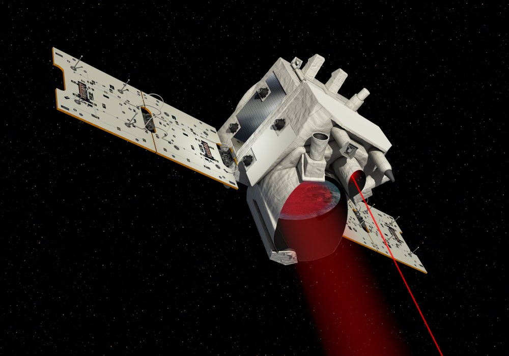
MERLIN, on the other hand, is an active Lidar instrument. It has its own 'light' (the laser) and can therefore also carry out measurements at night or even through thin cirrus clouds. To measure the concentration of a particular trace gas, light pulses are emitted at two closely spaced wavelengths. One wavelength is absorbed by the trace gas in question (lambda-on), the other is not (lambda-off). The methane concentration can be determined very precisely from the difference between the two signals scattered back from the ground.
The measured values recorded by the satellite can be converted into global methane flow maps by scientists using data on wind speeds and directions. This method of so-called inverse modelling leads to representations from which the actual regional methane flows can be derived and compared.
Technology made in Germany
The technologies for the Lidar instrument that will be deployed on MERLIN are being supplied by German industrial companies and research institutes. The companies Airbus Defence and Space (Ottobrunn), OHB (Munich), Cassidian Optronics (Oberkochem) and Jena Optronik (Jena), as well as the Fraunhofer Institute for Laser Technology (Aachen), among others, have developed and tested technologies for future Lidar instruments in various projects funded by the German Space Agency at DLR and ESA.
On the German side, scientific responsibility for the instrument lies with the Lidar department of the DLR Institute of Atmospheric Physics in Oberpfaffenhofen. This department already develops and operates airborne Lidar systems, which are used for example to measure wind strength, water vapour, methane or carbon dioxide content in the atmosphere. The methane and carbon dioxide Lidar CHARM-F, developed by the Institute, and based on the same measuring principle as MERLIN, has already been used successfully for several years aboard DLR's HALO research aircraft, allowing this measuring method to be tested beforehand for the MERLIN mission.
In addition, a Lidar measuring instrument developed by DLR, CHARM (CH4 Airborne Remote Monitoring), has been detecting methane leaks in natural gas pipelines from a helicopter for several years now. The measurement accuracy of this Lidar will be improved and used on MERLIN in order to detect methane worldwide.
MERLIN – a Franco-German contribution to tackling climate change
The mission is the first joint project between Germany and France in the field of Earth observation since 1994 and was agreed by both nations at the Franco-German Council of Ministers conference in February 2010. With this step, the two largest space nations in Europe decided to make a visible contribution to better understanding the causes of climate change through their space agencies CNES and DLR.
France is entrusted with the overall system and the satellite bus – a so-called MYRIADE Evolution platform – as well as the operation of the satellite and the launch rocket. Germany is developing the methane Lidar instrument of the satellite. Both nations are jointly responsible for the payload ground segment and the scientific analysis of the resulting methane data.
Between 2010 and 2015, CNES and the German Space Agency at DLR jointly conducted a scientific concept and technical feasibility study and developed the preliminary technical design of the satellite system. The final design phase was successfully completed in 2020. The satellite is scheduled to be launched into space in 2028. The main contractor is still Airbus Defence and Space GmbH in Ottobrunn, supported by several subcontractors, in particular the Fraunhofer Institute for Laser Technology Aachen, which is responsible for the laser subsystem.
Launch | 2028 |
Orbital altitude | approx. 500 kilometres |
Type of orbit | near-polar Sun-synchronous orbit |
LTAN | 6 or 18 hours |
Satellite mass | approx. 430 kilograms |
Satellite dimensions | approx. 1000 x 1000 x 1400 millimetres |
Instruments | Methane lidar (made in Germany) |
Measuring principle | Integrated Path Differential Absorption (IPDA) LIDAR |
Instrument mass | approx. 150 kilograms |
Instrument dimensions | approx. 820 x 830 x 1010 millimetres |
Satellite bus | MYRIADE Evolution (developed in France) |
Lidar power | approx 150 watts |
Laser range | 1645.552 nm (lamdba-on)/1645.846 nm (lambda-off) |
Laser pulse energy | 9 milliJoules |
Laser pulse repetition rate | 2x20 herz |
Mission duration | 3 year |
Links
Downloads
- Factsheet MERLIN (387.1 KB)