Angustus Labyrinthus – the 'Inca city' at Mars' icy south pole
Mars Express mission
Angustus Labyrinthus – the 'Inca city' at Mars' icy south pole
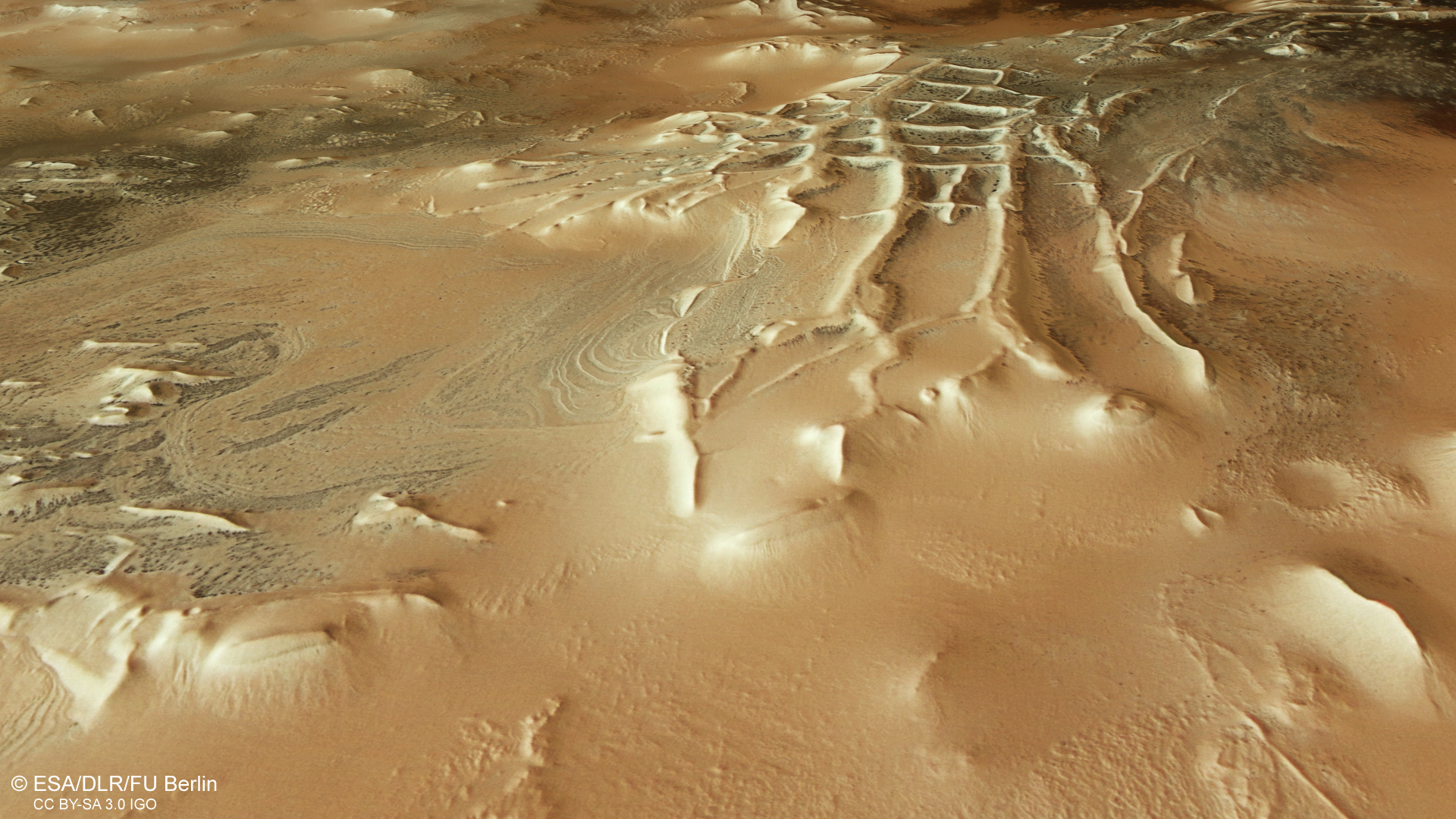
Unusual structures in the Angustus Labyrinthus region
On 27 February 2024, DLR's HRSC Mars camera imaged the Angustus Labyrinthus region near the south pole of Mars. On a high plateau, several ridges a few kilometres in length run in a straight line and at right angles to each other. The resulting pattern was discovered as early as 1972 in images taken by NASA's Mariner 9 spacecraft, reminding scientists of the ruins of the Inca city of Machu Picchu in the Peruvian Andes. This is why the structure is still informally referred to in Mars research as 'Inca city'. Various processes are under discussion as to the origin of this structure.
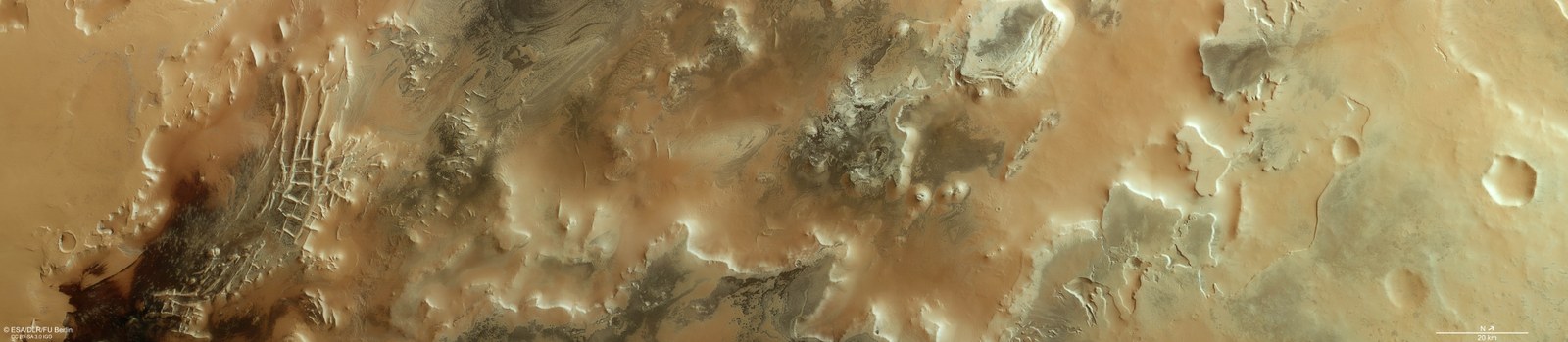
The Angustus Labyrinthus region near the south pole of Mars
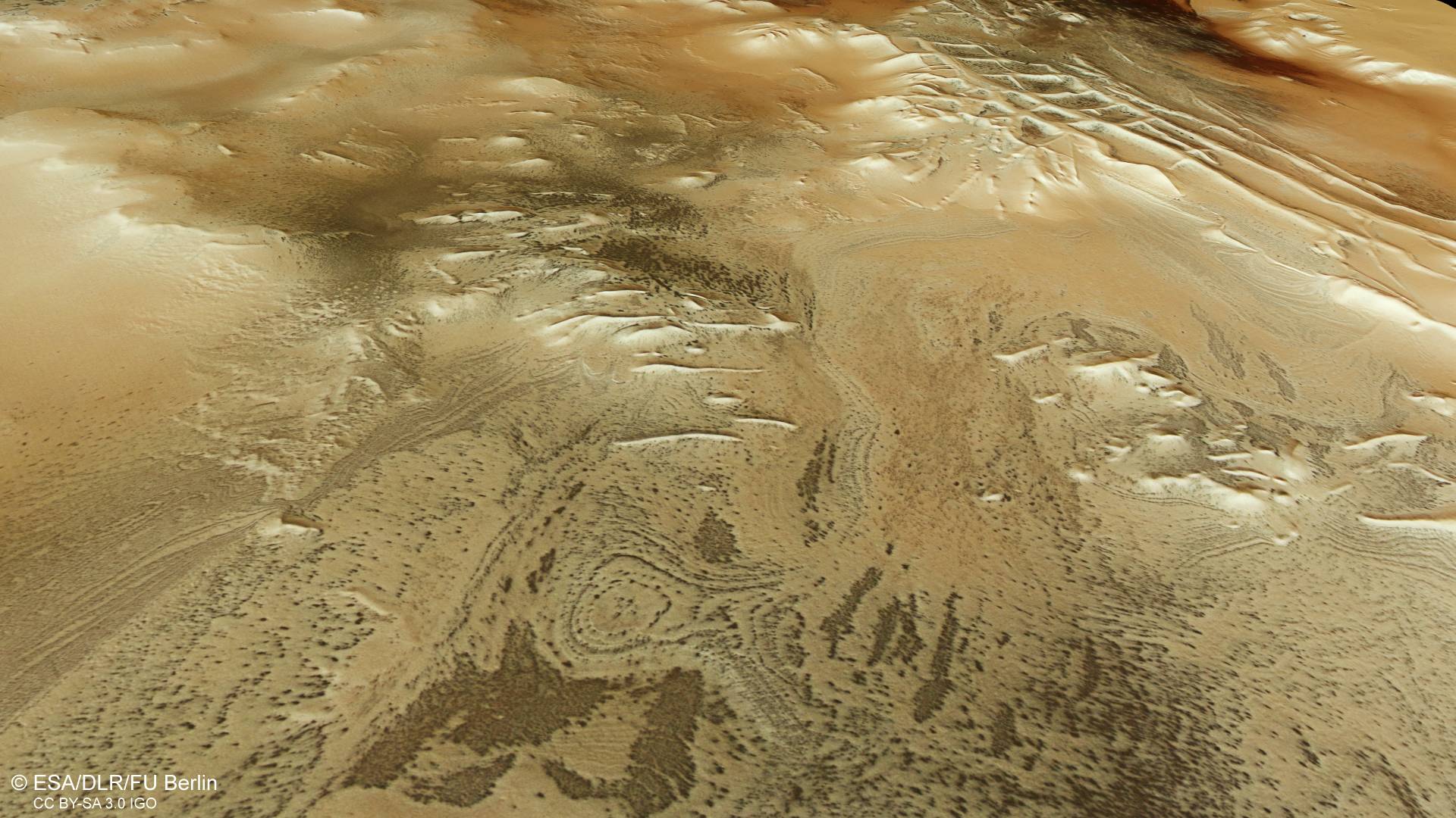
This vertical top view of Angustus Labyrinthus shows the diverse, sometimes exotic martian landscapes at a latitude of around 80 degrees south. In winter, here, near the South Pole of Mars, the landscape is covered for many years by coarse-grained dry ice, which trickles out of the planet's atmosphere at temperatures as low as minus 130 degrees Celsius. In addition to the polygons of the 'Inca city' in the left (southern) third of the image, dark areas and patches are particularly striking. These presumably occur when the underlying ice, at its base, sublimates in the spring and the resulting carbon dioxide gas expands and creates pressure. The overlying ice cracks, and through it dark sands are pulled to the surface during the sudden gas eruption.
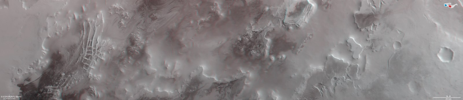
3D anaglyph image of the Angustus Labyrinthus region
So-called anaglyph images can be generated from the nadir channel of the HRSC camera, operated by DLR on the ESA Mars Express spacecraft. The nadir channel is directed vertically onto the surface of Mars and is one of four oblique stereo or photometric channels. When using red-blue or red-green glasses, they enable a three-dimensional view of the landscape and give the viewer a spatial idea of its height differences. In this way, the polygons of the 'Inca city', the structure of the table mountains and the high plateaus of the region can be clearly observed.
A new image from DLR's Mars High Resolution Stereo Camera (HRSC) shows the enigmatic Angustus Labyrinthus in the south polar region of Mars.
The structure exhibits a rectilinear pattern of ridges and internal polygons.
The reason for the formation of these landscape features is still unclear.
Focus: spaceflight, Mars, planetary research, Solar System exploration
Ridge networks that are more or less at right angles to each other can be found in numerous places and geological contexts on Mars. The best-known example of this is Angustus Labyrinthus, captured (left) in an image taken by the High Resolution Stereo Camera (HRSC) on board ESA's Mars Express spacecraft, impressively showing this enigmatic area in the south polar region of Mars. The HRSC is a camera experiment that was developed by the German Aerospace Center (Deutsches Zentrum für Luft- und Raumfahrt; DLR) and has been in operation for over 20 years.
Cause of formation still unclear
The Angustus Labyrinthus structure in the high southern latitudes, located just 500 kilometres from Mars' south pole, was discovered back in 1972 from data acquired by the US Mariner 9 spacecraft. It exhibits a rectilinear pattern of ridges and internal polygons reminiscent of the ruined city and World Heritage Site of Machu Picchu in Peru, and is informally known on Mars as the 'Inca City'.
How these landscape features came to be has been debated ever since. Initially, it was considered that they could be solidified dune ridges, originally made of loose sediment particles that were transformed into solid rock over time. It is more likely that these barriers are narrow, vertical corridors of solidified lava or 'dykes'.
The elevations are part of a large circular structure with a diameter of 86 kilometres. An asteroid impact is therefore also a possible explanation. According to this theory, deep faults created by the impact were filled with rising magma, which solidified in the form of polygonal fissures. Later, the softer material surrounding the polar plains was eroded, leaving behind ridges of the harder components of magmatic rock.
Another hypothesis is that the elevations are related to the neighbouring Dorsa Argenta Formation, which has many elongated ridges that have been interpreted as so-called 'eskers'. The term comes from the Irish word 'Eiscir' (gravel ridge) and refers to elongated, sometimes curved ridges that formed from deposits in glacial rivers and remain now as inverted river valleys, so to speak, after glacial retreat. However, eskers do not have the polygonal structures that can be seen in Inca City.
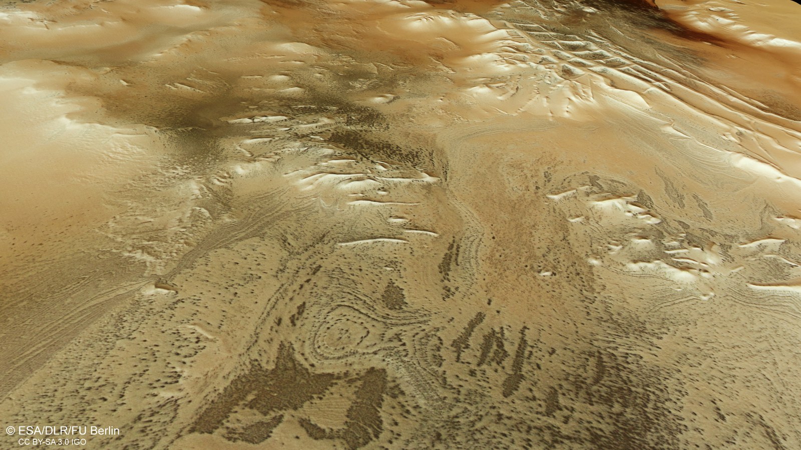
Layers and hints of seasonal changes in Angustus Labyrinthus
This image shows large eroded and layered deposits, rounded and oval in shape. The dark deposits are probably the result of periodic, seasonal bursts of carbon dioxide gas escaping from the winter ice cap at the beginning of spring, which brings dark sands to the surface.
The south polar region of Mars has a striking abundance of exotic landforms, most of which occur in regions that are covered by a seasonal ice cap. These HRSC images show darker regions in the centre left (southern) side of the image. On closer inspection, these dark surfaces consist of many small dark patches, which can be found in all other polar regions of Mars. They range in size from just under 50 metres to one kilometre and are probably caused by the escape of sand- and dust-laden carbon dioxide gas from beneath the bright ice surface: when carbon dioxide condenses at the South Pole in the late martian autumn and winter, it forms a 0.5- to one-metre-thick seasonal cap of bright, coarse-grained dry ice that covers dark sand deposits around the polar region.
This layer of dry ice is largely transparent to visible light, but impermeable to the thermal infrared spectrum. This means that sunlight can penetrate the ice layer and heat the underlying base, which leads, in spring, to the sudden transformation of the dry ice into a gaseous state. The gas, pressurised by expansion, is then trapped in the dark sands beneath the layer of ice. If the pressure continues to rise, the ice cracks and a sudden eruption of gas occurs, during which time dark material is carried away from the cavity, giving rise to dark patches on the ice surface.
It is assumed that this process is an important mechanism for carbon dioxide exchange between the polar ice cap and the atmosphere. If you were to zoom in on the dark spots with higher-resolution images, you would see thin lines beginning at some of these spots – formed when pressurised carbon dioxide escapes along weak zones in the ice and the underlying material is deposited around the dark spot like spider legs. This is why these structures are also referred to as 'spiders' in Mars research. NASA's Mars Reconnaissance Orbiter has repeatedly photographed such unusual 'araneiform terrain' (from the Latin 'Aranea' for spider).
Eroded layered deposits with large roundish and oval shapes can be seen in the centre of the image. This part of the image is dominated by several 'mesas' (from the Spanish word for 'table') measuring over 1500 metres in height. Interestingly, the spider phenomenon can be found everywhere in the image and at all altitudes, even on large mesas and on some steep flanks. Further to the right (northern) part of the image, the dust coverage of the surface appears much higher. And once again, on the neighbouring plateau, there are many 'spiders', as well as some gullies and hollows which probably testify to the periodic transition from a solid to a gaseous state.
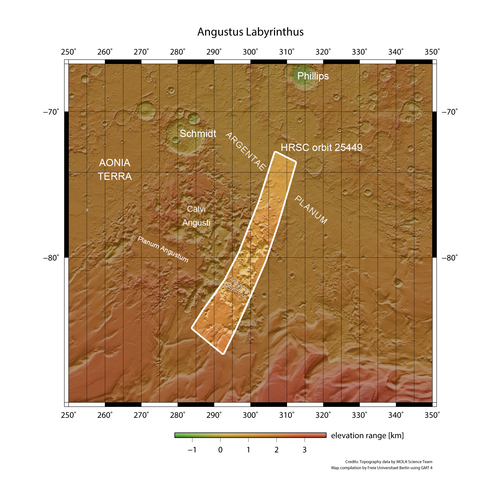
Regional context of the Angustus Labyrinthus region
The image strip photographed by DLR's HRSC on board ESA's Mars Express spacecraft on 27 February 2024 during orbit 25,449 covers an area almost 800 kilometres wide between 73 and 87 degrees south latitude near the south pole of Mars. In winter, this area is covered by the ice cap, which expands seasonally to the north. The image strip also contains the structure Angustus Labyrinthus, informally referred to by scientists as the 'Inca city'. The 200-kilometre-diameter Schmidt crater at 72 degrees south latitude is named firstly after the Soviet scientist and statesman Otto Julius Schmidt (1891-1956), and secondly after the German astronomer and geophysicist and long-time director of the National Observatory of Athens, Johann Friedrich Julius Schmidt (1825-1884). Schmidt's diligence was legendary: according to his own statements, he mapped 32,856 craters on the moon single-handedly.
These images were acquired by the HRSC (High Resolution Stereo Camera) on 27 February 2024 during Mars Express orbit 25,449. The ground resolution is about 15 metres per pixel and the image is centred at about 300 degrees east and 79 degrees south. The colour image was created with data from the nadir channel – the field of view perpendicular to the surface of Mars – and the colour channels of the HRSC. The oblique perspective view was created from the digital terrain model, the nadir channel and the colour channels of the HRSC. The anaglyph image, which gives a three-dimensional impression of the landscape when viewed with red/blue or red/green glasses, was derived from the nadir channel and a stereo channel. The colour-coded topographical view is based on a digital terrain model (DTM) of the region, from which the topography of the landscape can be derived. The reference body for the HRSC-DTM is a Martian equipotential surface (areoid).
The High Resolution Stereo Camera (HRSC) was developed at the German Aerospace Center (DLR) and built in cooperation with industrial partners (EADS Astrium, Lewicki Microelectronic GmbH and Jena-Optronik GmbH). The science team, led by Principal Investigator (PI) Daniela Tirsch from the DLR Institute of Planetary Research, consists of 52 co-investigators from 34 institutions and 11 nations. The camera is operated by the DLR Institute of Planetary Research in Berlin-Adlershof.


